
Landrecourt-Lempire
| Landrecourt-Lempire | ||
|---|---|---|
|
||
| region | Grand Est | |
| Department | Meuse | |
| Arrondissement | Verdun | |
| Canton | Dieue-sur-Meuse | |
| Community association | Val de Meuse-Voie Sacrée | |
| Coordinates | 49 ° 6 ' N , 5 ° 21' E | |
| height | 209-326 m | |
| surface | 14.63 km 2 | |
| Residents | 211 (January 1, 2017) | |
| Population density | 14 inhabitants / km 2 | |
| Post Code | 55100 | |
| INSEE code | 55276 | |
_mairie.JPG) Town hall (Mairie) of Landrecourt-Lempire |
||

Landrecourt-Lempire is a French commune with 211 inhabitants (as of January 1, 2017) in the Meuse department in the Grand Est region (until 2015: Lorraine ). The municipality belongs to the Arrondissement of Verdun , the canton Dieue-sur-Meuse (until 2015: Canton Souilly ) and the communal association Communauté de communes Val de Meuse-Voie Sacrée . The inhabitants are called Landrecourtois .
geography
Landrecourt-Lempire is located about nine kilometers south-southwest of the city center of Verdun . Landrecourt-Lempire is surrounded by the neighboring communities of Baleycourt in the north, Billemont in the north and north-east, Dugny-sur-Meuse in the east, Senoncourt-les-Maujouy in the south, Lemmes in the south-west, Les Souhesmes-Rampont in the west and south-west and Nixéville-Blercourt in the West.
The A4 autoroute runs through the municipality .
history
On January 1, 1973, Landrecourt and Lempire-aux-Bois were merged to form today's municipality.
Population development
| year | 1962 | 1968 | 1975 | 1982 | 1990 | 1999 | 2006 | 2013 |
|---|---|---|---|---|---|---|---|---|
| Residents | 115 | 93 | 140 | 184 | 203 | 176 | 207 | 194 |
| Source: Cassini and INSEE | ||||||||
Attractions
- Saint-Maurice Church in Landrecourt, built in 1790
- Saint-Firmin church in Lempire-aux-Bois, rebuilt in 1931
- French military cemetery
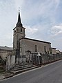
Saint-Maurice Church

Saint-Firmin church
_%C3%A9glise.JPG)

literature
- Le Patrimoine des Communes de la Meuse. Flohic Editions, Volume 2, Paris 1999, ISBN 2-84234-074-4 , pp. 886-887.