Cousances
| Cousances | ||
|
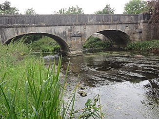
Bridge over the Cousances in Aubréville |
||
| Data | ||
| Water code | FR : H1130600 | |
| location | France , Grand Est region | |
| River system | His | |
| Drain over | Aire → Aisne → Oise → Seine → English Channel | |
| source | in the municipality of Souilly 49 ° 1 ′ 13 ″ N , 5 ° 17 ′ 56 ″ E |
|
| Source height | approx. 283 m | |
| muzzle | in the municipality of Aubréville in the Aire coordinates: 49 ° 8 ′ 33 ″ N , 5 ° 4 ′ 41 ″ E 49 ° 8 ′ 33 ″ N , 5 ° 4 ′ 41 ″ E |
|
| Mouth height | approx. 176 m | |
| Height difference | approx. 107 m | |
| Bottom slope | approx. 3.7 ‰ | |
| length | approx. 29 km | |
| Catchment area | 167 km² | |
| Right tributaries | Vadelaincourt | |
The Cousances is a river in France that runs in the Meuse department in the Grand Est region . It rises in the municipality of Souilly , generally drains in a north-westerly direction and flows into the Aire after around 29 kilometers in the municipality of Aubréville as a right tributary .
Places on the river
(Order in flow direction)
- Souilly
- Ippécourt
- Julvécourt
- Ville-sur-Cousances
- Jubécourt , municipality of Clermont-en-Argonne
- Brabant-en-Argonne
- Parois , municipality of Clermont-en-Argonne
- Aubréville
Web links
Commons : Cousances (river) - Collection of images, videos and audio files
Individual evidence
- ↑ Source geoportail.gouv.fr
- ↑ estuary geoportail.gouv.fr
- ↑ a b c The information on the length of the river is based on the information about the cousances at SANDRE (French), accessed on September 9, 2013, rounded to full kilometers.
