Bakoye
|
Bakoye Bakoy |
||
|
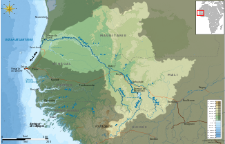
Catchment area of Senegal with the Bakoye (bottom right) |
||
| Data | ||
| location |
West Africa Guinea Mali |
|
| River system | Senegal | |
| Drain over | Senegal → Atlantic | |
| source | Monts Ménien 11 ° 50 ′ 0 ″ N , 9 ° 45 ′ 0 ″ W. |
|
| Source height | 760 m | |
| confluence | at Bafoulabé with Bafing to Senegal Coordinates: 13 ° 48 ′ 50 ″ N , 10 ° 49 ′ 41 ″ W 13 ° 48 ′ 50 ″ N , 10 ° 49 ′ 41 ″ W |
|
| Mouth height | 83 m | |
| Height difference | 677 m | |
| Bottom slope | 1.2 ‰ | |
| length | 560 km | |
| Catchment area | 85,600 km² | |
| Discharge at the Oualia gauge (1112320) A Eo : 84,400 km² Location: 70 km above the mouth |
NNQ MNQ 1951–1990 MQ 1951–1990 Mq 1951–1990 MHQ 1951–1990 HHQ (max. Month Ø) |
0 l / s 200 l / s 141 m³ / s 1.7 l / (s km²) 642 m³ / s 1382 m³ / s |
|
Bridge over the Bakoy near Toukoto (in the twenties) |
||
Bakoye ( Mande for "White River"; also Bakoyé and Bakoy ) is a river in West Africa . It flows through Guinea and Mali . At Bafoulabé in southwest Mali, in the Kayes region , it merges with the Bafing and becomes Senegal .
course
The river rises at an altitude of 760 meters from the Monts Ménien mountain in the north-west of Siguiri (Guinea). It flows north and forms part of the natural border between Guinea and Mali. It then meanders through the Manding Plateau and runs parallel to the Baoulé , which rises to the west of Bamako . The two rivers merge and then flow together with the Bafing at Bafoulabé to Senegal.
The Bakoye is a total of 560 km long and has a catchment area of 85,600 km³.
Hydrometry
The Bakoye has the most water in September, when the West African monsoons have just started. There is almost no water in January and June. The West African monsoons and their changing intensity have a major impact on the river system. In the dry period of 1972, a mere 30 m³ / s were measured at the measuring station in Oualia (about 70 km from the estuary), while in 1958 the discharge was 260 m³ / s. The average runoff in the period from 1951 to 1978 was 156 m³ / s. The annual flow averaged 4.9 km³. At the mouth of the river in Bafoulabé, the Bakoye accounts for a third to half of the discharge.
The average monthly flow of the Bakoye measured at the hydrological station at Oualia in m³ / s (1951–1990).

Individual evidence
- ^ A b c Mamdouh Shahin: Hydrology and Water Resources of Africa . Kluwer, New York 2002, ISBN 978-1-4020-0866-5 , pp. 379 .
- ↑ a b c Caractéristiques physiques du fleuve Sénégal. (No longer available online.) Organization pour la mise en valeur du fleuve Sénégal, archived from the original on July 16, 2013 ; Retrieved June 2, 2012 (French). Info: The archive link was inserted automatically and has not yet been checked. Please check the original and archive link according to the instructions and then remove this notice. .
- ↑ a b GRDC - Oualia gauge
- ^ Mahamadou Maïga: Le bassin du fleuve Sénégal: de la Traite négrière au développement sous-régional autocentré . L'Harmattan, 1995, pp. 14, footnotes 4 and 5 .
- ↑ SENEGAL-HYCOS: Renforcement des capacités nationales et régionales d'observation, transmission et traitement de données pour contribuer au développement durable du bassin du Fleuve Sénégal (Document de projet préliminaire) . Système Mondial d'Observation du Cycle Hydrologique (WHYCOS), 2007, p. 4 ( whycos.org [PDF; accessed May 29, 2012]). SENEGAL-HYCOS: Renforcement des capacités nationales et régionales d'observation, transmission et traitement de données pour contribuer au développement durable du bassin du Fleuve Sénégal (Document de projet préliminaire) ( Memento des Originals of December 28, 2013 in the Internet Archive ) Info: The archive link was inserted automatically and has not yet been checked. Please check the original and archive link according to the instructions and then remove this notice.
- ^ A b Hydrographic data for Oualia, Mali 1951-1978. (No longer available online.) Unesco International Hydrological Program, archived from the original on December 3, 2009 ; Retrieved June 2, 2012 . Info: The archive link was inserted automatically and has not yet been checked. Please check the original and archive link according to the instructions and then remove this notice.
- ↑ Étude des impacts environnementaux du projet d'aménagement de Félou . Organization pour la mise en valeur du fleuve Sénégal, 2006, p. 59-61 ( eib.org [PDF]).

