Barberine
| Barberine | ||
|
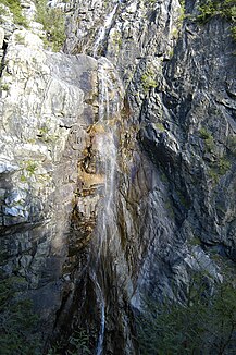
The Grande Cascade (the great waterfall) |
||
| Data | ||
| Water code | FR : V0370580 , CH : 104 | |
| location | Switzerland , France | |
| River system | Rhône | |
| Drain over | Eau Noire → Trento → Rhône → Mediterranean | |
| origin | in the Lac d'Emosson reservoir , Switzerland 46 ° 4 ′ 2 ″ N , 6 ° 55 ′ 55 ″ E |
|
| Source height | approx. 1920 m above sea level M. | |
| muzzle | near Barberine , (municipality of Vallorcine ), just under Swiss territory, in the Eau Noire Coordinates: 46 ° 3 ′ 2 ″ N , 6 ° 56 ′ 40 ″ E ; CH1903: 561748 / 100013 46 ° 3 '2 " N , 6 ° 56' 40" O |
|
| Mouth height | approx. 1130 m above sea level M. | |
| Height difference | approx. 790 m | |
| Bottom slope | approx. 26% | |
| length | 3 km (see notes) | |
| Catchment area | 33 km² | |
| Right tributaries | Nant de Drance | |
| Reservoirs flowed through | Lac d'Emosson | |
|
The origin of the Barberine, the Lac d'Emosson |
||
The Barberine is a torrent in the Valais Alps , which runs in the border area between Switzerland and France . The Barberine rises from the Lac d'Emosson in Switzerland, generally flows south to south-east and flows into the Eau Noire as a left tributary after about three kilometers within sight of the hamlet of Barberine (municipality of Vallorcine ), but just on Swiss territory . In its course, the stream does not always form the national border, but changes sometimes to France, sometimes to Switzerland. On his way he touches the Swiss canton of Valais and the French department of Haute-Savoie .
Individual evidence
- ↑ a b geoportail.fr (1: 16,000)
- ^ Geoserver of the Swiss Federal Administration.
- ↑ The information on the length of the river is based on the information about the Barberine at SANDRE (French), accessed on September 12, 209, rounded to full kilometers.

