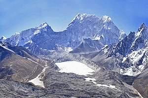
Baruntse
| Baruntse | ||
|---|---|---|
|
Baruntse from the south from the Hongu Valley |
||
| height | 7129 m | |
| location | Districts Sankhuwasabha , Solukhumbu ( Nepal ) | |
| Mountains | Mahalangur Himal ( Himalaya ) | |
| Dominance | 8.63 km → Shartse | |
| Notch height | 979 m ↓ ( 6150 m ) | |
| Coordinates | 27 ° 52 '18 " N , 86 ° 58' 49" E | |
|
|
||
| First ascent | May 30, 1954 by a New Zealand expedition | |
| Normal way | Glaciated alpine tour | |
|
Baruntse from the west (Imja valley) |
||
The Baruntse is a mountain in the Khumbu region (eastern Nepal ) with four peaks and bordered in the south by the Hunku glacier .
Neighboring mountains are Island Peak , Cho Polu and Num Ri .
The first ascent took place on May 30, 1954 over the south flank by a New Zealand expedition under Colin Todd and Geoff Harrow . On June 1, 1954, Bill Beaver and George Lowe , also expedition members, reached the summit. The Baruntse is considered to be relatively easy and safe to climb seven-thousand-meter peaks and is therefore often the destination of commercial expeditions.
Web links
Commons : Baruntse - collection of images, videos and audio files
- Baruntse on Peakbagger.com (English)
- Baruntse at Peakware (English)
- Baruntse at summitpost.org
- Altitude information according to the list of mountains> 6750 m on www.8000ers.com (accessed on November 14, 2009) .


