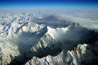
Batura Muztagh
| Batura Muztagh | ||
|---|---|---|
| Highest peak | Batura Sar ( 7795 m ) | |
| location | Gilgit-Baltistan ( Pakistan ) | |
| part of | Karakoram | |
|
|
||
| Coordinates | 36 ° 30 ′ N , 74 ° 31 ′ E | |
| Type | Fold Mountains | |
|
View from the Karakoram Highway to (from left to right) Ultar Sar and Bojohagur Duanasir, Shispare, Pasu Diar and the Passu Glacier |
||
The Batura Muztagh is the westernmost mountain range of the Karakoram Mountains .
It is located in the Gilgit-Baltistan Special Territory in Pakistan . The Batura Muztagh is the only part of the Karakoram main chain that lies west of the Hunza Valley. The Batura Glacier runs centrally in the mountain range . To the south of it rises the so-called "Batura Wall", an approximately 40 km long mountain ridge with the most important peaks of the Batura Muztagh. The highest point is the Batura Sar or Batura I with 7795 m . This was first climbed on June 30, 1976 by the Germans H. Bleicher and H. Oberhofer.
Selected peaks
| summit | Height (m) |
First ascent |
Ascent attempts † |
|---|---|---|---|
| Batura Sar | 7,795 | 1976 | 4 (6) |
| Shispare | 7,611 | 1974 | 3 (1) |
| Pasu Sar | 7,476 | 1994 | 1 (0) |
| Ultar Sar | 7,388 | 1996 | 2 (5) |
| Sangemarmar Sar | 7,000 | 1984 | 1 (3) |
|
Bublimotine ( Ladyfinger Peak ) |
6,000 | 1982 | 2 (5) |
† : Numbers in brackets indicate different information.
Other mountains worth mentioning are Kuk Sar , Kampire Dior , Koz Sar , Sani Pakush , Bojohagur Duanasir and Hachindar Chhish .
Web links
- alpinist.com West Karakoram Bonanza (panorama of the Batura Muztagh)


