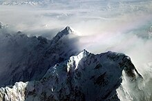
Shispare
| Shispare | ||
|---|---|---|
|
The Shispare from the southwest |
||
| height | 7611 m | |
| location | Gilgit-Baltistan ( Pakistan ) | |
| Mountains | Batura Muztagh ( Karakoram ) | |
| Dominance | 16.18 km → Batura Sar | |
| Notch height | 1241 m ↓ ( 6370 m ) | |
| Coordinates | 36 ° 26 '27 " N , 74 ° 40' 52" E | |
|
|
||
| First ascent | July 21, 1974 by Hubert Bleicher , Leszek Cichy , Herbert Oberhofer , Marek Grochowski, Jan Holnicki-Szulc, Andrzej Mlynarczyk, Jacek Poreba | |
| Normal way | Southeast route | |
|
The Shispare above the Passu Glacier |
||
The 7,611 m high Shispare is after the multi-peaked Batura Sar the second highest mountain of the Batura Muztagh , the westernmost part of the Karakoram in the autonomous region of Gilgit-Baltistan , the former Pakistani northern areas. Other names of this mountain are Shispare Sar and Shisparé Sar .
location

The Shispare is located east of the Batura Sar. It towers over the west side of the Hunza River, which stretches in a long loop from the south-west to the north-west of the Batura Muztagh. Ultar Sar and Bojohagur Duanasir are located southeast of Shispare .
The Shispare towers above its surrounding area unusually far. For example, the nearby city of Karimabad is located in the Hunza Valley at 2060 m . The summit of the mountain is only 13 km away as the crow flies, but around 5550 m higher. Because of its location on the edge of the Batura Muztagh, there are several large waterfalls in its immediate vicinity. The Shispare also has a strikingly large and steep northeast flank that slopes down to the Passu Glacier .
Ascent history
Mountaineering started later in Batura Muztagh than in other parts of the Karakoram. The Shispare was the first main peak of the mountains, which was successfully climbed in 1974 by the Polish-German academic expedition led by Janusz Kurczab . The climb took 35 days. While the preparations for a second rope team and a renewed ascent were in progress, the expedition member Heinz Borchers was killed by an avalanche. The route of the first group followed the Passu Glacier to the east ridge, which lies on the border with the Ghulkingletscher . (It should be noted that this ridge first leads southeast from the summit, but then turns to the northeast and finally tapers to the east. Therefore, in the springs it is sometimes referred to as a southeast ridge but also as a northeast ridge.) The rope team encountered difficulties on a long ice ridge which required a 1500 m long fixed rope to overcome .
The next attempt was made in 1989 by a Japanese expedition made up of members of the Ryukoku University Alpine Club, and led by Masato Okamoto . The group was on the mountain for almost two months, but failed to reach the summit in several attempts; its highest point was about 7200 m .
In 1994 a Japanese group from the Komono Alpine Club led by Yukiteru Masui reached the summit as the last group for the time being. They reached base camp on June 18, and Masui , Kokubu, and Ozawa reached the summit on July 20. They followed the same path chosen for the first ascent and climbed in a similar style with a similar amount of fixed rope. The Himalayan index tables do not list any further attempted ascent.
Climb
The first route to the summit is described above. It is likely that every other ascent trail has similar difficulty, making it a high difficult summit.
Books / pamphlets / maps via Shispare
- High Asia: An Illustrated History of the 7000 Meter Peaks by Jill Neate, ISBN 0-89886-238-8
- Batura Mustagh (sketch map and pamphlet) by Jerzy Wala, 1988.
- Orographical Sketch Map of the Karakoram by Jerzy Wala, 1990. Published by the Swiss Foundation for Alpine Research.
- American Alpine Journal , 1975, pp. 215-216
- American Alpine Journal , 1990, pp. 294-295
- American Alpine Journal , 1995, pp. 295-296
Web links
- Shispare on Peakbagger.com (English)
- Himalayan index
- Microsoft Encarta Map of Shispare
- A clickable map of the Batura Muztagh
- A short entry in French about the first ascent.
- DEM files for the Himalaya
- A world peak list by reduced spire measure
- Aerial Photos of Shispare by Brian McMorrow
Individual evidence
- ↑ Janusz Kurczab: Asia, Pakistan, Shispare, Batura Muztagh . American Alpine Journal, 1975, vol. 20th


