Batura Sar
| Batura Sar - Batura I. | ||
|---|---|---|
|
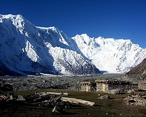
The Batura wall with the Batura I (to the right of the apparently higher peak in the center of the picture) above the Batura glacier |
||
| height | 7795 m | |
| location | Gilgit-Baltistan ( Pakistan ) | |
| Mountains | Batura Muztagh ( Karakoram ) | |
| Dominance | 62.98 km → Distaghil Sar | |
| Notch height | 3118 m ↓ Mingteke Pass ( 4677 m ) | |
| Coordinates | 36 ° 30 '37 " N , 74 ° 31' 21" E | |
|
|
||
| First ascent | June 30, 1976 by Hubert Bleicher and Herbert Oberhofer | |
| Normal way | glaciated alpine tour | |
Batura Sar , Batura I , Batura East or Peak 32 is the 25th highest mountain on earth and the highest peak of Batura Muztagh , the westernmost mountain range of the Karakoram .
location
It is almost in the center of the Batura Muztagh in the autonomous region of Gilgit-Baltistan in Pakistan .
topography
It owes its fame among mountaineers to its 10 km long and 7000 m high flank, the Batura Wall , and the fact that there is no higher mountain in the world to the north or west of it. In addition, it does not have a real peak, but a long ridge, the highest point of which is 7795 m . Overall, the main ridge of the Batura Muztagh seldom falls below the 6000 meter mark over a length of approx. 85 km.
Minor peaks
- Batura II, also known as Hunza Kunji or Peak 31 ( 7762 m ), notch height : 230 m
- Batura III ( 7729 m )
- Batura IV ( 7600 m )
- Muchu Chhish ( 7453 m ), after Gangkhar Puensum , which is forbidden to climb, the second highest unclimbed peak on earth
Ascent history
The first registered climber in the area was Matthias Rebitsch , who was in the icefall area on the north side of the summit in 1954, but made no attempt to reach the summit. The first attempt at ascent was made in 1959 by a rope team consisting of three British and two Germans. All five are believed to have died in an avalanche on the descent. It is not certain whether they reached the summit ( Batura Muztagh Expedition 1959 ).
The first ascent of the summit was achieved in 1976 by the Göppingen Karakorum-Himalaya expedition led by Alexander Schlee . On May 21, they set up the base camp on the Baltar Glacier under the southern flank of the mountain. Starting from the camp, Hubert Bleicher and Herbert Oberhofer reached the summit on June 30th. The route led from the Baltar East Glacier over the Batokshi Peak (called “Saddle Peak” by the first expedition) to the Batokshi Pass (“Batura Saddle”). Then they climbed diagonally to the east ridge and then to the summit. They used five high camps in their ascent. The second ascent was carried out in 1983 by an Austrian group who chose a new path to the left of the first. Jill Neate contradicts in her book High Asia the representation of the Himalayan index, according to which there was a further ascent in 1984. The last ascent for the time being was carried out in 1988 by a Polish-German expedition led by Piotr Młotecki. The Poles Zygmunt Heinrich - he was one of the first to climb the Kunyang Chhish in 1971 - and Paweł Kubalski and the German Volker Stallbohm reached the summit on July 13th. However, the expedition failed at its second goal, to reach the secondary peak Batura I West.
The Himalayan index records five other unsuccessful attempts to reach the summit, including an Austrian winter attempt.
swell
- High Asia: An Illustrated History of the 7000 Meter Peaks by Jill Neate, ISBN 0-89886-238-8
- Batura Mustagh (sketch map and pamphlet) by Jerzy Wala, 1988.
- Orographical Sketch Map of the Karakoram by Jerzy Wala, 1990. Published by the Swiss Foundation for Alpine Research.
Web links
- Batura Sar on Peakbagger.com (English)
- Batura at Peakware (English)
- Batura I at summitpost.org
Individual evidence
- ↑ Batura I on www.himalaya-info.org (accessed April 9, 2009)
- ↑ Batura II on Peakbagger.com (English)
- ↑ Hubert Bleichinger: Batura I. In: American Alpine Journal 1977, pp. 273f. (AAJO) , accessed November 17, 2012.
- ↑ http://www.alpine-club.org.uk/hi/index.htm
- ^ Paweł Kubalski: Batura. In: American Alpine Journal 1989, p. 262. (AAJO) , accessed November 17, 2012.


