
Beerentalbach
| Beerentalbach | ||
 Mouth of the Beerentalbach |
||
| Data | ||
| Water code | CH : ZH101308 | |
| location |
Mittelland
|
|
| River system | Rhine | |
| Drain over | Töss → Rhine → North Sea | |
| Headwaters | south of the settlement Weierhöhe 47 ° 28 '10 " N , 8 ° 46' 20" O |
|
| Source height | approx. 510 m above sea level M. | |
| muzzle | west of Sennhof in the Töss coordinates: 47 ° 28 ′ 8 ″ N , 8 ° 45 ′ 16 ″ E ; CH1903: 699 199 / 258400 47 ° 28 '8 " N , 8 ° 45' 16" O |
|
| Mouth height | 474 m above sea level M. | |
| Height difference | approx. 36 m | |
| Bottom slope | approx. 24 ‰ | |
| length | 1.5 km | |
| Catchment area | 1.79 km² | |
| Left tributaries | Mulchlingerbach | |
| Big cities | Winterthur | |
The Beerentalbach is a one and a half kilometers long, right tributary of the Töss in the Swiss canton of Zurich . The stream rises south of the Weierhöhe settlement , flows through the Sennhof district and flows into the Töss at its western end.
etymology
In 1569 the brook was mentioned as Beerennbächli. This designation lasted up to modern times, as Rutishauser also described the water as Beerennbächli. The stream flows through the Berry Valley, whether the stream takes its name from the valley itself, in which the corresponding berries were found, or whether it was derived from a corresponding bank planting, is questionable, although Rutishauser assumed the latter for "objective reasons".
geography
course
The Beerentalbach rises at 510 m above sea level. M. south of the Weierhöhe settlement belonging to the Gotzenwil district . After about 500 meters it flows south of the Grienen with the Mulchlingerbach coming on the left . The stream then flows east of the Tösstalbahn and passes under it and the Tösstalstrasse around 300 meters further. The creek crosses the Sennhof district on the remaining 500 meters to 474 m above sea level. M. at the western end of the quarter not far from where the Häsentalbach flows into the Töss.
Catchment area
The catchment area of the brook is around 1.79 km² and includes Nübrechte , a small part of the Eschenbergswald , Sennhof and parts of the Gotzenwil and Iberg districts . The catchment area of the brook is limited in the north by that of the Mattenbach and in the south is the catchment area of the Bolsternbach .
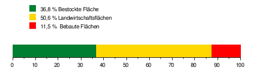
The area of its catchment area consists of 36.8% wooded area , 50.6% agricultural area and 11.5% settlement area .
The mean height of the catchment area is 529 m above sea level. M. , the minimum height is 474 m above sea level. M. and the maximum height at 591 m above sea level. M.
Tributaries
- Mulchlingerbach ( left ), 0.6 km
Web links
- Beerentalbach in Sennhof in Winterthur Glossary.
- Area of influence of the Hellbach
- Course of the Beerentalbach on the GIS browser Zurich
Individual evidence
- ↑ a b c GIS browser Canton Zurich, accessed on December 10, 2018
- ↑ Geoserver of the Swiss Federal Administration ( information )
- ↑ Jörg Rutishauser: The names of the running waters in the Winterthur district . In: New Year's Gazette of the Winterthur City Library . No. 298 . Buchdruckerei Konkordia, Winterthur 1967, p. 137 & 138 .
- ↑ see area of influence of the Hellbach