
Belur
| Belur ಬೇಲೂರು |
|||
|---|---|---|---|
|
|||
| State : |
|
||
| State : | Karnataka | ||
| District : | Hassan | ||
| Sub-district : | Belur | ||
| Location : | 13 ° 10 ′ N , 75 ° 52 ′ E | ||
| Height : | 975 m | ||
| Area : | 4.56 km² | ||
| Residents : | 22,484 (2011) | ||
| Population density : | 4931 inhabitants / km² | ||
 |
|||

Belur ( Kannada : ಬೇಲೂರು Bēlūru ) is a provincial town in the Indian state of Karnataka with around 24,000 inhabitants.
location
Belur is located in the Hassan district around 220 km (driving distance) west of Bangalore and around 38 km northwest of the district capital Hassan at an altitude of around 975 m in the Deccan highlands in the south of Karnataka. The city is the capital of the Taluks (sub-district) Belur. The national highway NH 234 ( Villupuram - Mangalore ) runs through Belur. On the northern outskirts of the city is the Yagachi Dam on the Yagachi River . The climate is warm; Rain falls mostly in the months May to October.
population
Official population figures have only been collected and published since 1991.
| year | 1991 | 2001 | 2011 |
| Residents | 16,827 | 20,228 | 22,484 |
About 74% of the population are Hindus and 25% Muslim . The male and female proportions of the population are roughly the same. The main language is Kannada , which according to the 2001 census is spoken by 64% of the population as their mother tongue. Urdu (23%) is common among Muslims . Smaller minorities speak Telugu (4%), Tamil (3%), Marathi (2%) and Malayalam (1%).
history
From the 12th to the 14th century Belur belonged to the heartland of the Hoysala empire, whose former capital Dorasamudra , today's Halebid , is only about 15 km northeast.
Attractions

- The beginning of the Chennakesava Temple, which was built at the beginning of the 12th century and which the Hoysala king Vishnuvardhana had built after his conversion from Jainism to Hinduism , reminds of the Hoysala period . Together with the temples of Halebid and Somanathapura , the Chennakesava temple is one of the most important temple structures of Hoysala architecture , which is characterized above all by extremely filigree figure reliefs and the use of turned soapstone columns. The main shrine, which is dedicated to the god Krishna in his form as Chennakesava , stands in the center of a 132 × 108 m temple complex.
- The similarly designed but significantly smaller Cap Chennigaraya Temple was built at the same time by Queen Shantaladevi . The vestibule is illuminated by numerous Jali windows.
- The Ranganayaki Shrine is a small temple with a flat-roofed open porch ( mandapa ) from the early 12th century.
- The Veera Narayana Temple is a small temple with a flat-roofed but closed porch from the late 12th century.
- The approximately 12 m high victory column commemorates a victory of the Hoysala over the Chalukya dynasty.
- The monumental-looking gate ( gopuram ) of the temple complex is a work of the late 14th century when Belur belonged to the Vijayanagar empire .
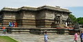
Main shrine of the Chennakesava temple

Shiva kills the elephant demon Gajasura
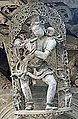
Flute player
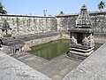
Temple pond at the Chennakesava temple

Cap Chennigaraya Temple

Ranganayaki Shrine


_(14484824431).jpg)
_at_the_Chennakeshava_temple_in_Belur.jpg)
_in_Belur.JPG)
