Berre (Mediterranean)
| Berre | ||
|
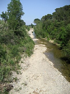
The river before it flows into the lagoon lake |
||
| Data | ||
| Water code | FR : Y08-0400 | |
| location | France , Occitania region | |
| River system | Berre | |
| source | in the parish of Quintillan 42 ° 57 ′ 10 ″ N , 2 ° 42 ′ 9 ″ E |
|
| Source height | approx. 427 m | |
| muzzle | in the municipality of Port-la-Nouvelle in the Mediterranean Coordinates: 43 ° 0 ′ 48 ″ N , 3 ° 4 ′ 7 ″ E, 43 ° 0 ′ 48 ″ N , 3 ° 4 ′ 7 ″ E |
|
| Mouth height | approx. 0 m | |
| Height difference | approx. 427 m | |
| Bottom slope | approx. 8.1 ‰ | |
| length | 53 km | |
| Catchment area | approx. 628 km² | |
| Flowing lakes | Etang de Bages et de Sigean | |
| Small towns | Port-la-Nouvelle | |
The Berre is a coastal river in France that runs in the Aude department in the Occitanie region . It rises in the landscape of the Corbières , in the municipality of Quintillan , drains generally in a north-easterly direction, reaches the Regional Nature Park Narbonnaise en Méditerranée and initially flows into the lagoon lake Étang de Bages et de Sigean at Peyriac-de-Mer . Their water masses then flow in the lake to the southeast and reach the Mediterranean after a total of 53 kilometers in the municipality of Port-la-Nouvelle .
Places on the river
(Order in flow direction)
- Quintillan
- Cascastel-des-Corbières
- Villeneuve-les-Corbières
- Durban-Corbieres
- Portel-des-Corbières
- Peyriac-de-Mer
- Port-la-Nouvelle
Web links
Commons : Berre - collection of images, videos and audio files
Individual evidence
- ↑ Source geoportail.gouv.fr
- ↑ estuary geoportail.gouv.fr
- ↑ a b Water information system , Service d'Administration National des Données et Référentiels sur l'Eau (French) ( information ), accessed on November 28, 2016, rounded to full kilometers
- ↑ Girault de Saint-Fargeau, 1799–1855 .: Histoire nationale ou dictionnaire géographique de toutes les communes du département de l'Aude, ouvrage orné de cartes, de gravures, de portraits et de vignettes . Les Éd. de la Tour Gile, 1996, ISBN 2-87802-265-3 .

