Bettenhausen (Glan-Münchweiler)
|
Bettenhausen
Local community Glan-Münchweiler
|
||
|---|---|---|
| Coordinates: 49 ° 28 ′ 9 ″ N , 7 ° 26 ′ 55 ″ E | ||
| Height : | 220 m above sea level NHN | |
| Incorporation : | 7th June 1969 | |
| Postal code : | 66907 | |
| Area code : | 06383 | |
|
Location of Bettenhausen in Rhineland-Palatinate |
||
|
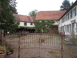
Rübscher Hof in Bettenhausen
|
||
Bettenhausen is a district of the municipality of Glan-Münchweiler in the Kusel district in Rhineland-Palatinate . Until 1969 it was an independent community.
location
Bettenhausen is located in the North Palatinate Uplands on the right bank of the Glan opposite the main town of Glan-Münchweiler. It was originally a street village on what is now known as "Bettenhausen" or "Bettenhausener Straße", which connects Glan-Münchweiler with Niedermohr . South of the settlement area, opposite the village, the Eichenbach flows into the Glan from the left .
history
The place was first mentioned in 1393 as "Bottenhausen". Bettenhausen belonged to the Electoral Palatinate until the end of the 18th century . From 1798 to 1814, when the Palatinate was part of the French Republic (until 1804) and then part of the Napoleonic Empire , the place was incorporated into the canton of Landstuhl ; At that time he formed a community with Niedermohr and was subordinate to the Mairie Obermohr . In 1815 the place had 158 inhabitants. In the same year, Austria was struck. Just one year later, the place, like the entire Palatinate, changed to the Kingdom of Bavaria . In 1818 Bettenhausen was the smallest self-governing Bavarian community. From 1818 to 1862 he was a member of the Landkommissariat Homburg ; from this the district office of Homburg emerged.
Since part of the district office - including Homburg itself - was added to the newly created Saar area in 1920 , Bettenhausen moved to the newly created district office in Landstuhl . In 1928, Bettenhausen had 64 residents who lived in ten residential buildings. From 1939 the place was part of the district of Kaiserslautern . After the Second World War , Bettenhausen became part of the then newly formed state of Rhineland-Palatinate within the French occupation zone . Bettenhausen belonged to the mayor's office of Niedermohr until 1969.
In the course of the first Rhineland-Palatinate administrative reform , the previously independent community of Bettenhausen was separated from the Kaiserslautern district on June 7, 1969 and incorporated into the Kusel district. At the same time, today's local community Glan-Münchweiler was re-formed from the communities of Glan-Münchweiler and Bettenhausen. Since then, Bettenhausen has been expanded to include several new development areas.
religion
The Jews who temporarily lived there were buried in Gries . In 1928, 60 residents were Protestant and four were Catholic. The Protestants belonged to the parish of Glan-Münchweiler, the Catholics to that of Kirchmohr . Jews were no longer living in the village at this point.
coat of arms
| Blazon : "The coat of arms of the former municipality of Bettenhausen shows half a blue lion with a yellow tongue and yellow claws on a silver background in the upper half, and a silver pole on a blue background in the lower half." | |
Culture
In the village of Bettenhausen there are three of the ten objects that are under monument protection , including the Alte Mühle am Glan and the Rüb farm. In addition, at the roundabout shortly before Bettenhausen there is a gym wheel monument in honor of its inventor Otto Feick , who temporarily lived in the village.
Infrastructure
The federal highway 423 touches the northwestern edge of the settlement. The Glan-Münchweiler train station on the Landstuhl – Kusel railway line is just a few hundred meters from the town .
Individual evidence
- ↑ Martin Dolch, Albrecht Greule: Historisches Siedlungsnamesbuch der Pfalz. Speyer, Publishing House of the Palatinate Society for the Advancement of Science 1991, p. 59.
- ^ Community of Glan-Münchweiler. (No longer available online.) In: vg-glm.de. Archived from the original on December 9, 2012 ; accessed on September 13, 2015 .
- ↑ a b List of localities for the Free State of Bavaria. In: daten.digitale-sammlungen.de. Retrieved May 14, 2016 .
- ↑ Official municipality directory (= State Statistical Office of Rhineland-Palatinate [Hrsg.]: Statistical volumes . Volume 407 ). Bad Ems February 2016, p. 164 (PDF; 2.8 MB).
- ↑ a b History of Glan-Münchweiler - regionalgeschichte.net. In: regionalgeschichte.net. Retrieved September 13, 2015 .
- ^ Coat of arms of Bettenau. Heraldry of the world, accessed September 5, 2019 .
- ^ General Directorate for Cultural Heritage Rhineland-Palatinate (ed.): Informational directory of cultural monuments - Kusel district. Mainz 2019, p. 9 (PDF; 5.8 MB).


