
Mitrovica district
|
Rajoni i Mitrovicës ( Albanian ) Kosovsko-Mitrovački okrug / Косовско-Митровачки округ ( Serbian ) |
|
|---|---|
 _(UNMIK).svg) |
|
| Country |
|
| Area : | 2,052 km² |
| Residents | 232.833 |
| Population density | 110 / km² |
| District capital | Mitrovica |
| Communities | 6th |
| Villages | 267 |
| License Plate | 02 |
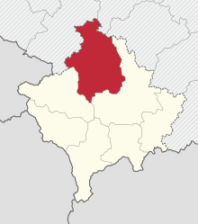
The district of Mitrovica ( Albanian Rajoni i Mitrovicës , Serbian Косовско-Митровачки округ Kosovsko-Mitrovački okrug ) is one of the seven Kosovar districts and is located in northern Kosovo.
On February 17th, 2008 the parliament of Kosovo declared independence from Serbia . Since then, the status has been controversial internationally.
For the Mitrovica district, 02 is the Kosovar license plate . In the communities where the majority of Serbs live, the old KM is used as a Serbian license plate , although according to the Kosovar government these have been illegal since 2012. The seat of the district is Mitrovica .
population

The 2011 census in Kosovo showed that 232,833 people live in Mitrovica district.
| city | local community | Urban space | ||
|---|---|---|---|---|
| 2011 | rank | 2011 | rank | |
| Mitrovica | 84,235 | 1 |
46.230 |
1
|
| Vushtrria | 69,870 | 2 |
26,964 |
2
|
| Skenderaj | 50,858 | 3 |
6,612 |
3
|
| Leposavić | 13,773 | 4th |
3,702 |
4th
|
| Zvečan | 7,481 | 5 |
1,297 |
5
|
| Zubin Potok | 6,616 | 6th |
1,724 |
6th
|
Communities
| local community | Official seat | Population (2011) | Area (km²) | Population density (km²) | Villages |
|---|---|---|---|---|---|
| Mitrovica | Mitrovica | 71,909 | 350 | 205.5 | |
| Vushtrria | Vushtrria | 69,870 | 344 | 203.1 | |
| Skënderaj | Skënderaj | 50,858 | 378 | 134.5 | |
| Severna Kosovska Mitrovica | Severna Kosovska Mitrovica | 29,460 | 11 | 2,678.2 | |
| Leposavić | Leposavić | 18,600 | 539 | 34.5 | |
| Zvečan | Zvečan | 16,650 | 122 | 136.5 | |
| Zubin Potok | Zubin Potok | 14,900 | 333 | 44.7 | |
| Mitrovica district | 272.247 | 2,077 | 131.1 | 267 |
Individual evidence
- ^ Kosovo Census . Retrieved June 6, 2017.
