Bila (Chemerivtsi)
| Bila | ||
| Біла | ||

|
|
|
| Basic data | ||
|---|---|---|
| Oblast : | Khmelnytskyi Oblast | |
| Rajon : | Chemerivtsi Raion | |
| Height : | 261 m | |
| Area : | 3.588 km² | |
| Residents : | 1,496 (2004) | |
| Population density : | 417 inhabitants per km² | |
| Postcodes : | 31643 | |
| Area code : | +380 3859 | |
| Geographic location : | 48 ° 54 ' N , 26 ° 29' E | |
| KOATUU : | 6825280401 | |
| Administrative structure : | 1 village | |
| Address: | вул. Жовтнева 2 31643 с. Біла |
|
| Statistical information | ||
|
|
||
Bila ( Ukrainian Біла ; Russian Белая Belaja ) is a village in the south of the Ukrainian Oblast Khmelnyzkyj with about 1500 inhabitants (2004).
The village, first mentioned in 1493, is the only village in the district council of the same name .
The village is located in Chemerivtsi Raion on the banks of the Batishok ( Батіжок ), a 24 km long tributary of the Smotrych between the Schwantschyk and Smotrych rivers , 25 km southeast of the Chemerivtsi district center and about 90 km southwest of the Oblast capital Khmelnitskyi .
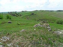
The botanical natural monument Samowyta Towtra ( Самовита Товтра ) and the geological natural monument Towtra "Perschak" ( Товтра "Першак" ) are located near Bila .
Individual evidence
- ↑ Local website on the official website of the Verkhovna Rada , accessed on November 27, 2015


