Waldegg (Linz)
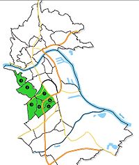
| Waldegg district of Linz | |
|---|---|
| Basic data | |
| political district | Linz (L) |
| Statistical districts |
Froschberg (1, 2), Bindermichl-Keferfeld (3, 4), Spallerhof (5, 6) |
| surface | 18.76 km² |
| Geographical location | 48 ° 17 ' N , 14 ° 18' E |
| height | 266 m above sea level A. |
| Residents | 37,369 (as of 2006) 1992 inhabitants per km² |
| Post Code | 4020 |
Waldegg is a former municipality that was incorporated into the Upper Austrian capital Linz in 1873 . 1957-2013 Waldegg was one of nine districts in Linz. It comprised the statistical districts Froschberg , Bindermichl-Keferfeld and Spallerhof , and it was also divided into these units in 2013 (with some boundary changes).
The cadastral community of the same name still exists in the area .
geography
Geographical location and neighboring communities
The cadastral community of Waldegg is located in the west of the Upper Austrian capital Linz and borders in the north on the cadastral community of the city center , in the east on the cadastral community of Lustenau , in the south on the cadastral community of Kleinmünchen and in the west on the neighboring city of Leonding in Linz .
Expansion of the cadastral community
The largest extension from east to west is around 3.5 km, from north to south around 4.75 km. The total area is 18.76 km².
Urban areas
Freinberg
The urban area of Freinberg is located in the west of Linz, on the southern foothills of the Freinberg. It borders on Römerberg-Margarethen in the north and east, Froschberg in the south and in the west on the city of Leonding . The area share in the urban area of Linz is 0.9%.
The Freinberg is one of the most beautiful and most expensive residential areas in Linz. In it are various noteworthy buildings such as:
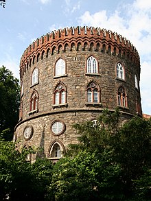
- Archduke Maximilian had the test tower built for military purposes in 1828
- the "Maximilian Chapel" was built in 1829 next to the trial tower. Archduke Maximilian donated the tower and the chapel to the Jesuits in 1837 . Today both buildings belong to the Kollegium Aloisianum.
- the seminar building, which was erected in 1853 for reasons of space next to the tower, which the Jesuit fathers used as a living and school room. This was the cornerstone of today's Kollegium Aloisianum , a private Catholic grammar school and secondary school.
- the Sonnenhof nursing home founded in 1850
- the Private Pedagogical University of the Diocese of Linz
- the Salesianum, Caritas school for social care professions for people with disabilities
- the MW radio transmitter Freinberg built in 1928 . Initially the system required two steel truss masts. After various modifications, only one mast is required today. This only serves as an antenna carrier and is located next to the telecommunications office.
- the Johannes Kepler observatory , built in 1983
The 405 meter high Freinberg , which was named in 1910 after the statistical district at the time, is a popular destination for Linzers with its extensive parks.
Frog mountain
The geological elevation Froschberg lies in the west of Linz. The urban area borders the Freinberg and Römerberg-Margarethen in the north, the Volksgartenviertel in the east and Keferfeld in the south. The Andreas-Hofer-Platz district also borders on Froschberg in the south and the city of Leonding in the west. The area share in the urban area of Linz is 1.8%.
The name Froschberg goes back to the clay pits and brickworks that were originally located here. The water collected in the dug clay pits and one or two frogs settled here. Today the Froschberg is a popular residential area in Linz - quiet, green and close to the center. While there are many ÖBB residential buildings in the western part , the eastern part around the Gugl is one of the most expensive residential areas in the city. The striking parish church of St. Konrad is located on the highest elevation . Froschberg is the sporting center of the city. The Tips Arena Linz stands on a hill, which is called a "Gugl" in local parlance. Sports occasions and events of all kinds can be held there. The Linz stadium with over 20,000 seats is just opposite. It is the home of FC Blau Weiß Linz and the Linz Athletic Sport Club (LASK). Because of its location, the stadium is often just called "Gugl". The name of the Gugl meeting also referred to the location.
Keferfeld
The urban area of Keferfeld is located in the west of Linz. It borders the Froschberg in the north, the Andreas-Hofer-Platz district and the Bindermichl in the east, the Kleinmünchen district in the south and the municipality of Leonding in the west . The part of Oed north of the Europastraße also belongs to the Keferfeld. The area share in the urban area of Linz is 1.5%.
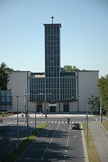
Keferfeld was incorporated into Linz in 1939 together with other parts of the Leonding community, which are now in the statistical districts of Bergern and Froschberg. Leonding, however, remained as a city and was not incorporated by order of Adolf Hitler . This makes the Keferfeld the youngest part of the city. During the time of incorporation, the first part of the row house settlements that defined the townscape was built (architectural style of the Nazi era), the construction of which was continued after the Second World War. The striking parish church of Keferfeld was built with the architect Rudolf Schwarz from 1959 to 1962.
Today, the Keferfeld is a popular residential area, which differs from the neighboring Bindermichl district in that it is less dense. The main traffic axis is the Landwiedstrasse. The Theresienkirche, the Keferfeldschule built in 1912, the Volkshaus Keferfeld-Oed and the Landwiedstraße school center (including BRG Landwiedstraße ) are among the striking buildings in this district.
Bindermichl
The urban area of Bindermichl is located in the southwest of Linz. In the north it borders on the Andreas-Hofer-Platz district, in the east on the Wankmüllerhofviertel and the Spallerhof, in the south on Bergern and in the west on the Keferfeld. The area share in the urban area of Linz is 1.1%.
The name "Bindermichl" is derived from the name of a farm that was in what is now the area until 1940. In 1940 the estate was expropriated by the Hermann-Göring-Werke housing cooperative in order to build a large housing estate on it. During the war, the Bindermichl developed into a densely populated residential area for workers in today's VÖEST plants . In 1957 the Bindermichl received its landmark, the parish church of St. Michael. The Hummelhofbad, which was rebuilt in 1993 and 2005/2006 and is still very popular, was also opened in the 1950s. Not far from the Church of St. Michael there is a primary and secondary school as well as a Volkshaus.

The townscape is still determined by the residential buildings built during the Nazi era. Due to the direct location on the city motorway, many residents complained about the traffic noise. This was largely minimized by the not undisputed Bindermichl enclosure of the A7 . Due to the good connection to public transport and leisure facilities such as the Hummelhofbad and the attached park (Hummelhofwald), the Bindermichl is a popular residential area.
"Am Bindermichl" is the central street of the Bindermichl, which is connected to the A7 via Muldenstraße and a large roundabout . Muldenstraße also provides the direct connection from Bindermichl to Spallerhof and the Wankmüllerhofviertel.
Other important streets in the Bindermichl are Stadlerstrasse (shopping center), Uhlandgasse (Volkshaus), Werndlstrasse and Ramsauerstrasse (grammar school).
Spallerhof

The urban area of Spallerhof is located on a hill in the southwest of Linz. It borders in the north on the Wankmüllerhofviertel, in the east on the Makartviertel, in the south on the New World and in the west on the Bindermichl. The area share in the urban area of Linz is 0.7%.
The name “Spallerhof” is derived from the “Speilern”, a professional group that was responsible for the production of round wood and that settled in the area of today's Spallerhof around 1300. The "Gut am Speilerberg", from which the "Spallerhof" was to develop over the centuries, was first mentioned in a document on August 3, 1475. In 1693 the area became the property of Waldhausen Abbey, after which it became part of the Waldegg community . This was incorporated into Linz in 1873. The Spallerhof did not become a densely populated residential area until the Nazi era. At that time, cheap and functional apartments were needed for the workers and employees of the newly built "Hermann Göring" works (today VÖEST ). The residential complexes that still characterize the townscape were created, the shape of which was based on the typical regional square courtyards.
After the Second World War, ethnic Germans and “displaced persons” found a temporary home in barracks at Spallerhof. The second wave of construction began in the 1950s, and the tall buildings (especially on Muldenstrasse) in the style of that time still tell of this today. In 1964 the most striking building of the Spallerhof, the parish church of St. Peter, was inaugurated. The A7 , which had separated the Spallerhof from the Bindermichl district since the late 1960s, was tunneled under in 2005, which resulted in an enormous reduction in noise pollution for the residents. The Spallerhof is by far one of the "oldest" districts of Linz in terms of population structure. In addition, he is still closely associated with the VÖEST steelworks, whose workers and employees as well as retirees still make up a large proportion of the residents.
The distinctive buildings include the Catholic parish church of St. Peter , the Protestant Christ Church and the Glimpfingerstraße retirement home.
Wankmüllerhofviertel
The Wankmüllerhofviertel is located in the southwest of Linz. It borders in the north on the Andreas-Hofer-Platzviertel, in the east on the Makartviertel, in the south on the Spallerhof and in the west on the Bindermichl. The area share in the urban area of Linz is 0.7%.
The distinctive buildings include the WIFI building and the ÖAMTC headquarters in Upper Austria.
Andreas-Hofer-Platzviertel
The Andreas-Hofer-Platzviertel is located in the southern center of Linz. It borders the Volksgartenviertel in the north, the Makartviertel in the east, the Wankmüllerhofviertel in the south and Keferfeld and the Bindermichl in the west. The area share in the urban area of Linz is 1.3%.
The distinctive buildings include the AMS and BFI buildings on Bulgariplatz and also the Neuromed Campus , which was opened on September 22nd, 1867 as the Niedernhart insane asylum and was popularly known as "Guglhupf".
Incorporations
Freinberg, Froschberg, Bindermichl, Spallerhof, Wankmüllerhofviertel and the Andreas-Hofer-Platz district were incorporated into the municipality in 1873. Keferfeld and parts of Froschberg and Bergern (in Kleinmünchen ) were not incorporated into the municipality until 1939.
See also
literature
- Franz Dobusch, Johann Mayr (Hrsg.): Linz - city of work and culture. Gutenberg-Werbering, Linz 1997, ISBN 3-900401-43-8 .
- City research Linz: Linz 2000. Facts, pictures, graphics. CD-ROM, Linz 2000.
Web links
- Linz in numbers
- Historical photos of Linz . Accessed August 31, 2018.
Individual evidence
- ^ Linz - Politics / Administration - Linz Numbers - City Area (with an overview of the current statistical districts of Linz).
- ↑ Freinberg Church Hl. Maximilian, Jesuit Church at stadtgeschichte.linz.at, accessed on March 15, 2019.
- ^ Jesuit monastery Freinberg 1837 on stadtgeschichte.linz.at, accessed on March 15, 2019.
- ↑ www.leonding.at: Chronicle .


