
Binsfeld (lake)
| Binsfeld | ||
|---|---|---|

|
||
| View from the beach on the west bank of the central lake Binsfeld to the island in this lake. This is not allowed to be entered for reasons of bird protection. During the day, there are usually numerous water birds on and around the island. Some species use the island as a sleeping and nesting place. | ||
| Geographical location | Speyer , Rhineland-Palatinate , Germany | |
| Data | ||
| Coordinates | 49 ° 21 '29 " N , 8 ° 27' 13" E | |
|
||
| surface | 20 ha | |
| Maximum depth | 19 m | |

The Binsfeld Baggersee is the central point of the eight lakes in Binsfeld that have been dredged for the purpose of gravel extraction . It is located in the northernmost part of the Rhine lowlands of Speyer and belongs to the Speyer-Nord district . To the west of it lies the Sonnensee , northwest of the Mondsee , to the north are the Biersiedersee and Silbersee , east of the Gänsedrecksee and south of the Kuhunter .
Lake Binsfeld is separated from Lake Kuhunter by a headland that has become an island through two punctures, a small one on the west bank and a larger one on the east. On this peninsula / island is swimming allowed.
On its west, north, east and south shores, beaches are designated where bathing is allowed.
Surname
Except for the slightly higher ground in the northern part of the whole Binsfeld was characterized by marshy with reeds lined meadows . This explains the field name Binsfeld, which was transferred to the entire area, the lake dredged on the parcel and the construction area on the lakes and the main Binsfeld access road .
Bird island
In the 20 hectare large and maximally 19 meters deep lake Binsfeld, the center of the lake landscape Binsfeld, there is an island with rich water bird life , during the day especially a large colony of Canada geese , which is mostly called bird island, but officially has no name.
Bathing, nudism, DLRG
On the east bank of the Binsfeld a headland separates it from the Gänsedrecksee. The side of the headland facing the Binsfeld is designated as a nudist area.
For users of the west bank, there is also a kiosk with toilet facilities in the southern area on the headland that separates Binsfeld and Sonnensee. However, it is on the side facing the Sonnensee. There is also a rentable barbecue area on this headland.
The clubhouse and the watch station of the DLRG are located on the southern east bank .
History of the area
A plan to fence off the main beaches in the north and east after leasing them to a private person and allowing them to charge entry caused considerable political controversy in the 1980s. The contract was concluded, but the project failed due to the tenant's bankruptcy.
- Image gallery of Lake Binsfeld
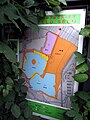
Usage regulations for Silbersee, Binsfeld, Gänsedrecksee and Kuhunter; yellow: beaches / area for bathers; blue: swimming is allowed; orange: nature reserve; purple: surfing; pink: parking lot
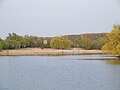
The main beach of the Binsfeld lake area on the north side of the lake of the same name. There is a group of tau willows on the beach. The flat, sandy north bank of the Binsfeld is the most popular bathing beach today. There is also a kiosk and toilet facilities there. The gravel works was located there until the end of the gravel mining .

Lake Binsfeld, view from north to south of the narrow opening to Lake Kuhunter and its south bank. The Binshof rest area on the A61 can be seen behind it. The drilling rig of the Römerberg 2 oil well is already behind the motorway in the south. In the background is the Speyer garbage dump.

Lake Binsfeld: View of the east bank, the headland that separates Binsfeld from the Kuhunteree. The area is used as a nudist beach in summer. The high row of trees in the background is already behind the Rheinhauptdeich and K2 and belongs to the floodplain area of the Rhine. At the back right you can see the top of the pylon of the suspension bridge over the A 61 motorway over the Rhine.

_-_Hauptstrand_am_Nordufer.jpg)


See also
Web links
- Aerial view of the lakes Lake Binsfeld is located in the middle of the area and can be clearly recognized on the island.
Common use (swimming, diving, rowing, surfing)
- The city administration of Speyer on the common use of the Binsfeld
- Bathing water quality. Rhineland-Palatinate bathing water atlas of the Rhineland-Palatinate Water Management Authority
fishing
Individual evidence
- ↑ Address Speyer 1991 DAYS POST-Verlag, S. 179th
- ↑ badeseen.rlp.de