
Speyer North
.jpg)
_S%C3%BCdwestansicht.JPG)


Speyer-Nord is the northernmost district of Speyer with around 10,000 inhabitants today (2016). The district arose in 1932 from a settlement that was built during the Great Depression by the new settlers in self-help with financial support from the Weimar Republic in accordance with the Reichsheimstättengesetz .
Position, extent, structure
The core of the new district a few hundred meters north of the Wormser Warte , which belonged to the old Speyer Landwehr , was far outside the traditional settlement area of Speyer and initially gave the z. B. churchgoers or students a walk of 5 km on the Wormser Landstrasse to the church service or school.
Wormser Landstrasse / Auestrasse industrial park
The core town used to end, apart from a row of houses along the Wormser Landstrasse to the municipal cemetery , south of the Woogbach , at the so-called Rushing Water. A large commercial and shopping area, Wormser Landstrasse, Neudeck, and the Rhein Auestrasse and its side streets, Tullastrasse, has now moved between the city center and Speyer-Nord. This area is z. B. in the parish boundaries counted mainly to Speyer-Nord (border Auestrasse).
Speyer East
The longer existing gap between the core city and this commercial area has been built on with residential areas from the core city in the last few decades. These areas are mostly referred to as Speyer-Ost because they are all east of the northern north-south connection of the city of Speyer, the Wormser Landstrasse. To the west of Wormser Landstrasse, at the height of Auestrasse, lies the very large, park-like Speyer cemetery, and further west an industrial area along the Speyer-Schifferstadt railway line, which is then followed by the Speyer-West district.
Speyer-West and industrial area North-West
The forest area in the southwest of Speyer-Nord, west of Schifferstadter Straße, which separated the district from the northern parts of the even younger district of Speyer-West , west of Iggelheimer Straße, has meanwhile given way to a large commercial and industrial area. The gaps in this area were also partially filled with residential buildings. The Speyer-Schifferstadt railway line and the Iggelheimer Strasse are the boundaries between the districts. In the sharp section of the terrain between these two traffic routes, there used to be a French barracks with a large vehicle depot , the Lyautey area , now the Lyautey industrial park
Groups of houses, Rinkenberger Hof, Kurpfalz barracks, farmsteads, lake areas
Speyer-Nord, which is also called a settlement because of its origins, has three more separate groups of houses, a large barracks and two lake areas.
In the far north-west, west of the B 9, is the Rinkenbergerhof , once a group of farms with a few forest workers' houses.
Kurpfalz barracks and branch offices

In the north of the core settlement there is the large Kurpfalz barracks which, while it is in use by the German armed forces, also has a branch in the Rhine valley for pioneer exercises and an on-site training area in the Speyer Forest .
The Bundeswehr base existed since then in December 1962 and January 1963 the parachute pioneer company 260 from Mannheim and the airborne artillery battalion 265 from Großengstingen moved to a newly built barracks north of the settlement. In order to create living space for the soldiers' families, GEWO built apartment blocks west of Spaldinger Straße in the forest area.
Lastly, the Special
Pioneer Battalion 464 with the following units was housed there: 1. / SpezPiBtl 464 (StVers)
2. / SpezPiBtl 464 (field camp)
3. / SpezPiBtl 464 (field camp)
4. / SpezPiBtl 464 (field camp)
5. / SpezPiBtl 464 (field camp )
6. / SpezPiBtl 464 (field camp)
7. / SpezPiBtl 464 (pipeline)
8. / SpezPiBtl 464 (military fire brigade)
The special pioneer battalion was the Bundeswehr's first operational battalion in a field camp and had a pipeline pioneer company . It was primarily structured for the Bundeswehr's foreign missions. The soldiers were involved in Bundeswehr missions abroad such as KFOR , EUFOR (until December 2, 2004 SFOR ) and ISAF .
Today, among other things, there is a branch of the Rhineland-Palatinate state initial reception center for refugees on the former barracks site .
Immediately south of the Bundeswehr branch in the Rhine lowlands between Binsfeld and Angelhofer Altrhein, with the opportunity to practice in the Angelhofer Altrhein, there has long been a location for French bridge pioneers, the Riberpray quarter , which is now used by the Bundeswehr. The Reffenthal water exercise area covers an area of 66.5 hectares.
Spitzrheinhof, Ketscher Fahr, Speyerlach

In the east, the middle of the field on the outermost edge of the high Gestades the Rhine valley, the farm group is Spitzenrheinhof , mostly as Spitzrheinhof referred. Below this group of farmsteads in the Rhine lowlands in part of the Altspeyer pasture there used to be an arm of the old Rhine. This was used by the Speyer ferry to Ketsch , the Ketscher Fahr , before silting up . This was first mentioned in 1231. Later a wet area that was called Speyerlach , the name was transferred to a quarry pond that was created there today north of the Rhine, the Speyerlachsee .
Binsfeld lake area and lakes south of the A 61
To the north of the A 61 , in the Rhine lowlands, there is the Binsfeld at some quarry ponds , where around 250 houses are used, some for living and some for weekend purposes. Of the eight quarry ponds north of the A 61, the Speyerlachsee , Mondsee , Sonnensee , Biersiedersee and Silbersee , the three largest lakes, Binsfeld , Kuhunter and Gänsedrecksee, are connected to one lake.
In the north of the Binsfeld lies the municipality of Otterstadt .
In the Rhine lowlands east of the old core settlement, south of the motorway, there are other large quarry ponds (from west to east) the Steinhäuserwühlsee with the Thomashof , the Wammsee with the Ludwigshof , the Deutsche Wühl with the Deutschhof and to the northeast, directly on the motorway, the Elendherbergswühl .
Surroundings and neighboring places
In the northwest of Speyer-Nord the Speyer forest and then Schifferstadt join, in the north Waldsee and Otterstadt , in the northeast over the Rhine Ketsch and in the east the municipality of Altlußheim .
Social life, churches

Due to its history and location, Speyer-Nord has its own society and association. The core of this life was initially the association of the settlers in the Siedlergemeinschaft Speyer e. V. and their community center, then the Protestant and Catholic communities, which soon became parishes.
A Catholic Church of St. Konrad was built in 1934.
The Protestants first built a community center on Eichenweg in 1935, west of the settler community center, and later the Christ Church with community center in 1962–1964 .
Later a whole series of clubs were added, starting in particular with the MGV Speyer-Nord choir and the ASV Speyer football club, which are now combined in the Speyer-Nord local cartel.
Highlights in social life are the traditional settlers ' festival in summer, the parish festivals of the two parishes, the “Vereinsmeier” settlers' carnival organized by several associations and, more recently, the Advent market on Heinrich-Lang-Platz.
In 1973 the Free Christian Community built a community center in Birkenweg. From 1985 to 1988 this community built the ARCHE community center, which was built for around 300 people, on the former settlers' festival area west of Birkenweg. The congregation belongs to the Federation of Free Church Pentecostal congregations KdöR.
Infrastructure and social facilities
The primary and secondary school settlement school is located in Speyer-Nord with two gyms and a multi-purpose hall. The Hauptschule will be converted into a Realschule plus .
Are available at the daycare Protestant daycare Noah's Ark , the Municipal daycare Rainbow , the Municipal nursery Treasure Island , the Urban integrative daycare dandelion and the Catholic Kindergarten St. Konrad .
The Post has a branch on Heinrich-Lang-Platz.
Sparkasse Speyer has had a branch in Speyer-Nord since 1956 and Volksbank since 1960.
Personalities
- Seppl Scherer , actually Josef Scherer, (born December 11, 1913-2005) is so far the only settler who has been honored with a path in the district, the Seppl-Scherer-Weg . The path connects the oak path with the settler community center and the old paths of the original settlement with the walnut path, where the cath. Church with the settlement area, today Heinrich-Lang-Platz, stands. Born in downtown Mehlgasse, he was a member of the board for a long time and from 1963–1976 he was chairman of the settler community, chairman of the ASV (General Sports Association) and the driving force behind the settler festival. He also launched the old people's parlor of the settler community, which still exists today (2008). Already in the pre-war period he was a member of the SPD and represented the district from 1964 to 1979 on the SPD list in the city council. However, when it came to issues such as school construction, road construction or transport links, etc., he acted as a non-partisan representative of the district. The award was made unanimously and with the participation of all mayors and parliamentary groups.
- Heinrich Lang played a major role in the development of the settlement, which is described below. In his honor, the central square of the settlement at the corner of Nussbaumweg / Birkenweg with St. Konrad as the eastern end was renamed Heinrich-Lang-Platz in 1965 (previously Am Anger ).
Street names
In the actual settlement the streets were named after trees, later also after some bushes, in the flower district east of Waldseer Straße after flowers, in the northwest corner after birds. Only the two people named above were honored with names of streets. The names of two Catholic churchmen, journeyman father Adolph Kolping and labor bishop Wilhelm Emmanuel von Ketteler mark the settlement project to the east of St. Konrad, supported by a Catholic association.
In the meantime, the new connection road leading over the Rhine lowlands to Auestrasse was named after the Rhine straightener Tulla , and scientists, engineers and industrialists were honored in the industrial area that displaced the forest between Speyer-Nord and Speyer-West.
The settlement
History of the settlement
background
In the global economic crisis that started in 1929, unemployment in Germany rose from 800,000 in 1928 to 6.2 million in 1932. The Weimar Republic attempted to overcome this unemployment and the then rampant housing shortage through housing programs. With three emergency decrees from Chancellor Heinrich Brüning , in which above all civil servants' salaries were cut, these and other measures were to be paid for. The settlement program started nationwide in 1931. The Minister of Finance, Herrmann Dietrich , wanted to build simple houses for families with gardens for self-sufficiency on municipal and state plots. The settlers should help a lot.
Heinrich Lang
In Speyer, the first-class housing construction officer, Dipl.-Ing. Heinrich Lang (* 1878–1938), board member of the Palatinate Housing Association for creating settler positions. Representatives of the construction industry feared missed orders and protested the proposal. While the plans were being discussed in the city, Heinrich Lang worked with the mayor at the time, Karl Leiling, and the city councilors to draw up drafts for a building area called "Ob der Sandgrube". 86 settler sites were to be created on the then land exercise area of the pioneers between Spaldinger Strasse (then Mutterstädter Strasse) and Waldseer Strasse north of the small sand pit (nowadays grove) far from the old town. The site was to be leased , after violent protests by Heinrich Lang, on long lease . Heinrich Lang also organized the raising of funds through the state, at that time for the Palatinate Bavaria , and the imperial government in Berlin.
City council resolution
On April 15, 1932, the Speyer city council voted for the project in the north with 26 yes and 3 no votes. Thoughts of realizing the project at the former pioneer training area on Landauer Strasse (in the south of the city) or in Erlich (in the west) had come to nothing. The city council made an area of 84,500 m² available. Even before the decision, however, the first four cellars had been excavated on April 8, 1932 in what would later become Kiefernweg.
financing
First of all, to pre-finance 38 apartments, the city of Speyer receives 95,000 Reichsmarks from the building and land bank as a loan, guaranteed by the Bavarian state.
Heinrich Lang had calculated building costs of 5,950 Reichsmarks for each of the 38 houses. The loan secured 40%. Each settler should contribute 53% personal contribution. Heinrich Lang made up for the missing 7% by supporting the building with the work of the unemployed, who received lunch and 7 Reichsmarks per week as payment.
Wilhelm Immesberger
Government building officer Wilhelm Immesberger was entrusted with building supervision and site management. The trained bricklayer, Immesberger, who comes from the northern Palatinate, had trained to become a certified structural engineer. Extensive work as a construction manager, he is also referred to in publications as an architect.
Commissioned by the mayor with the task of designing so-called people's apartments, he is reluctant to meet the conditions and calls the task “barracks”. He wanted to get people out of misery and not put them in new huts. Instead, he designs a model house and asserts himself with it. No apartment, he had demanded, should be built below 63 square meters. Immesberger also gave the unemployed practical guidance, for example on how to build walls. His saying has been handed down to mix concrete “stable, awwer ach net zu deier” (expensive). He won the settlers' trust and affection.
Construction progress, large and small settlements, Otterstadter Weg
On May 11, 1933, the finished shell structures of the first 7 semi-detached houses were raffled among 14 settler families under notarial supervision. The technique of raffling off a group of houses among the settlers who were working together after the shell had been completed should ensure that the helpers built all the houses with the same care and with the same amount of cement. This technique was later used in the Catholic settlement projects in Kolpingstrasse and Kettelerstrasse. By the end of 1934, 59 semi-detached houses for 118 families were built between Waldseer and Spaldinger Strasse under Immesberger's supervision. This area is called the Great Settlement. Six two-story houses are being built on Erlenweg east of Waldsser Strasse. These areas lie above the Rhine lowlands on sandy soils that were deposited by streams that used to run here.
In Otterstadter Weg, to the east of the large settlement, which runs along an old slope of an old Rhine loop that has long since silted up and which lies completely in the Rhine lowlands, 42 people's apartments were initially built and later another 36. This area was known as the Small Settlement or Small Settlement.
Time sequence
The first development of the large settlement of Kiefernweg, Eichenweg, Ahornweg, Ulmenweg took place in 1932, that of the Nussbaumweg in 1934, east of the Waldseer Straße in 1937 that of the Erlenweg and the Buchenweg, the latter with 27 houses. The Otterstadter Weg leading to the Spitzrheinhof was built on with the people's apartments from 1935.
Debt repayment, replacement of the long lease
In the first construction phase, the monthly payment obligation for the loan for the settler sites was 11 to 13 marks. The later houses with 79.5 m² of living space caused repayment obligations of 24 marks a month, with a usual weekly earnings of 25 Reichsmarks. But many unemployed people had less available.
The problems with long-term leases when the buildings were enlarged, sold and inherited were only resolved when, after the Second World War, with Mayor Langlotz, before the currency reform in 1948, a replacement of the long-term lease was made possible and the settlers became owners.
Picture gallery history of the settlement
House building

Typical settlement house in Speyer-Nord
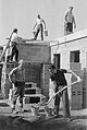
The houses were built in self-help and in community


Settlers Festival in the 1950s

6 a.m., wake-up call from the brass band for the settlers' festival

Athletics competitions took place from 8.00-10.00

The afternoon settlers parade used to take a good two hours


St. Conrad
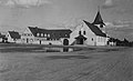
Altes St. Konradskirchlein, Speyer, 1934–1969

St. Konrad, Speyer, from the southeast

literature
- Ferdinand Schlickel : Topic on Saturday: the pioneering years of the settlement in Speyer-Nord. - Up to 14 working hours a day: between the two world wars there was a severe housing shortage. In: The Rheinpfalz Speyerer Rundschau. 55 (1999), No. 175 of July 31, 1999.
Individual evidence
- ↑ http://www.bundeswehrwiki.de/wiki/Speyer
- ↑ Christian Berger: Deduction lets conservationists flourish. In: The Rhine Palatinate . Speyerer Rundschau, November 19, 2011.
- ↑ Spitzrheinhof. In: Wolfgang Eger : Speyer street names. A lexicon. Herrmann G. Klein Verlag, Speyer 1985, ISBN 3-921197-08-X .
- ↑ Ferdinand Schlickel, Helmut Schollenberger, Hermann Hemmerich, Günther Ableiter (Red.), Kath. Pfarramt St. Konrad (Ed.): 50 years of St. Konrad in Speyer. 1934-1984. P. 18.
- ↑ Martin Hussong: The Christ Church in Speyer-Nord. In: Speyerer Siedlerfest 2005. pp. 37–41.
- ↑ http://www.arche-speyer.de/ Category: About us
- ↑ http://realschuleplus.rlp.de/
- ↑ Speyer Settlers Festival 2007. 75 years of the settlement. P. 114.
- ↑ Speyer Settlers Festival 2007. 75 years of the settlement. P. 101.
- ↑ Siedlergemeinschaft Speyer: Speyer Settlers Festival 2007. 75 years of the settlement. Article: Name "Seppl Scherer" adorns the way in Speyer-Nord. The shield is supposed to remember the former settler. P. 39; Chairwoman of the Speyer-Nord settlement community since it was founded . P. 43; Else Doll: Our portrait: Josef Scherer. Pp. 57-59.
- ↑ Ferdinand Schlickel : Up to 14 working hours a day. Housing shortage far and wide. From the first years of the settlement. In: Speyerer Siedlerfest 2006. published by the Siedlergemeinschaft Speyer eV, Robert Weber Offsetdruck OHG, Speyer 2006
- ↑ Siedlergemeinschaft Speyer eV: Speyer Settlers Festival 2007. 75 years of the settlement. Article 75 years ago construction began in the north of Speyer - Rolf Walther the first real "settlement worker". Pp. 11-13.
- ↑ from here again: Ferdinand Schlickel : Up to 14 working hours a day. Housing shortage far and wide. From the first years of the settlement. In: Speyerer Siedlerfest 2006. published by the Siedlergemeinschaft Speyer eV, Robert Weber Offsetdruck OHG, Speyer 2006
- ↑ only for this section: Wolfgang Eger : Speyerer street names. A lexicon. the street entries , Herrmann G. Klein Verlag, Speyer 1985, ISBN 3-921197-08-X ; further proof by F. Schlickel
Web links
Pictures of the first settlement construction
- Speyer-Nord: Model of the suburban housing estate in the German Digital Library
- Plan of a single house from 1932 in the German Digital Library
- Plan of the cross paths in the German Digital Library
- Shell reaches ground floor level in the German Digital Library
- In the background the cart for the sand supply, in the foreground two men mortar in the German Digital Library
- Entire detached house of the first settlement in the shell of the German Digital Library
- Housing estates in Speyer-Nord in the German Digital Library
St. Conrad
Aerial view
Coordinates: 49 ° 20 ′ 51 ″ N , 8 ° 25 ′ 45 ″ E