
Engstingen
| coat of arms | Germany map | |
|---|---|---|

|
Coordinates: 48 ° 23 ' N , 9 ° 17' E |
|
| Basic data | ||
| State : | Baden-Württemberg | |
| Administrative region : | Tübingen | |
| County : | Reutlingen | |
| Height : | 700 m above sea level NHN | |
| Area : | 31.51 km 2 | |
| Residents: | 5289 (December 31, 2018) | |
| Population density : | 168 inhabitants per km 2 | |
| Postal code : | 72829 | |
| Primaries : | 07129, 07385 | |
| License plate : | RT | |
| Community key : | 08 4 15 089 | |
| LOCODE : | DE EGT | |
| Community structure: | 4 districts | |
| Address of the municipal administration: |
Kirchstrasse 6 72829 Engstingen |
|
| Website : | ||
| Mayor : | Mario Storz ( CDU ) | |
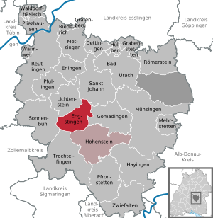
| Location of the municipality of Engstingen in the Reutlingen district | ||
  |
||

Engstingen is a three villages and a business park existing community in Baden-Wuerttemberg with well 5100 inhabitants. It is located on the plateau of the Swabian Alb in the area of the Middle Kuppenalb .
geography
Geographical location
Engstingen is located on the northern edge of the Swabian Alb, at an altitude of 680 to 750 meters on the Alb plateau near the Alb eaves . It is located in the Ur- Lauter valley , about 15 km as the crow flies south of the district town of Reutlingen .
geology

The Alb plateau was formed when the plate of the White Jura was raised about 50 million years ago . Many cracks and crevices formed in this calcareous rock, so that rainwater seeps away very quickly and the Alb is fairly arid. Nevertheless, there is a mineral spring in the Kleinengstingen district.
Expansion of the municipal area
The districts of Großengstingen and Kleinengstingen are together. They are surrounded by a wreath of wooded hilltops.
The district of Kohlstetten is about 3.5 kilometers northeast, the Haid business park about four kilometers south.
The lowest point of the marking at 673 m is on the railway line at the marking boundary to Offenhausen, the highest point at 820 m on the Judenstein at the marking boundary to Meidelstetten.
Neighboring communities
The following cities and municipalities border the municipality of Engstingen, they belong to the district of Reutlingen :
| Lichtenstein | St. Johann | |
| Sonnenbühl |
.svg)
|
Gomadingen |
| Trochtelfingen | Hohenstein |
Community structure
In the course of the community reform on January 1, 1975, the three previously independent communities Großengstingen , Kleinengstingen and Kohlstetten were combined to form the new community Engstingen .
The village of Großengstingen and the groups of houses in Großengstingen and Haid belonged to the former community of Großengstingen.
Only the villages of the same name belonged to the former communities of Kleinengstingen and Kohlstetten.
Since the Eberhard Finckh barracks were dissolved , the Haid industrial park, as part of the hamlet of Haid located on federal road 313, has also largely belonged to the municipality. This is also the boundary between Engstingen and the neighboring town of Trochtelfingen
In contrast, the main part of the Haid residential area south of the junction to the Trochtelfingen business park belongs.
history
Common
The earliest permanent traces of settlement date from the Hallstatt period ( barrows in the Haid area). The area was part of the Roman Empire ( agri decumates ) from the first to the third century .
Both Engstingen are places of the Alemannic conquest of the 5th century. A political separation may come early as the 8th century by an allocation to various Frankish Gaugrafschaften established (Großengstingen to Burichingagau , Kleinengstingen to Pfullichgau ). Nevertheless, the locations in the historical tradition are often difficult to distinguish from one another.
During the Thirty Years' War all three sub-towns suffered major population losses, which in the course of time led to an increased influx of foreign families, many from Switzerland.
Since 1806 the places were part of the newly founded Kingdom of Württemberg and since 1918 of the free People's State of Württemberg . In 1945 the places fell into the French occupation zone and thus belonged to the newly founded state of Württemberg-Hohenzollern , which was incorporated into the current state of Baden-Württemberg in 1952.
Grossengstingen
The Alemannic settlement was built at the intersection of several Roman roads (see Alblimes ) . Alemannic row graves can be found on the eastern edge of the village. The earliest place name evidence of Anegistingin dates to January 24, 783 in a deed of donation from the Lorsch Monastery , which had properties in the village. At the beginning of the 10th century the diocese of Chur acquired goods. Chur gave the developing rule of Engstingen as a fiefdom to various noble lords, on October 16, 1419, to Hans von Liechtenstain ("Herr Hannsen blessed von Liechtenstain, ritters, elicher svn"), who signed and seals a fiefdom reverse for the rule of Grossengstigen. On November 29, 1419, the same Hans, son of the blessed knight Hans von Liechtentain, confirmed that "Bishop Johann ze Chur had granted me a right man's fief, namely the church sentence ze Engstingen in Swaben and the village of that same, with all their rights and belonging, It also includes undungen and the goods that we hand from Liechtenstain there, and Ze Muettelstetten, what we do there, and ze Erpffingen,… ze Bernloch… Kolstetten,… Hon under Liechtain, Aberhusen, Underhusen in the Honower valley, Pfulingen and Melchingen ... ". On August 14th, 1438 (catalog of Bishop Flugi, document no. 19) the rule (Gross) -Engstingen was transferred to Wolf von Neuhausen ( Neuhausen .) By “Hanns von Liechtenstain, her Schwengers von Liechtenstain, ritters, saeligen svn, and his brother Wolf / Fildern ). The brothers had inherited the rule of Gross-Engstingen from Hennslein von Liechtenstain saelig, mins cousin Wernhers saeligen svn von Liechtenstain “. The name Großengstingen appears for the first time in 1439 . The name Churengstingen was less common .
There was a dispute in the area about free stalking; the general hunting rights of the citizens. The hunters Gerstenecker (minor form: Gersteneckher, Eck (her)), Hummel, Stahlecker (minor form: Staheleckher) and Schneider hunted a deer in 1577 in what they believed to be free stalking and were arrested by the forester. The city of Ebingen was represented by a lawyer from Tübingen in the long-standing legal dispute. In 1559 Albrecht of Bavaria brokered a contract. In 1583 new boundary stones with the inscription Pirsch (Bürsch) and Forst (Vorst) were set on the Swabian Alb. In 1709, free stalking was abolished and from 1713 to 1806 it was partially reintroduced as a ducal mercy hunt.
After the Neuhausen family died out in 1635, Engstingen was no longer lent; it was now a direct part of the secular state rulership of the Diocese of Chur. The castle of the Lords of Neuhausen was demolished in the 18th century.
On October 31, 1717, the Engstingen estate was sold by Chur to the Zwiefalten monastery . From this, Großengstingen came to the Protestant Württemberg on April 30, 1750 , which subordinated the place to its rent chamber, but had it co-administered by the Pfullingen office. In 1806, Großengstingen became part of the Reutlingen Regional Office (from 1938 "district").
From 1963 to 1993 the rocket artillery battalion 250, an association of the German armed forces, was stationed in the Eberhard Finckh barracks in Großengstingen .
Small boys
Kleinengstingen, only a little to the east of Großengstingen, was built on a basalt tuff chimney that carried water . An Alemannic row grave field can be found northwest of the village.
The oldest known name "Clain Engstingen" dates from 1482. Due to the rule of the barons of Engstingen (liber de Anegestingen) mentioned in the 13th century , the place was sometimes also called Freiengstingen . However, the place was probably already under the suzerainty of Württemberg at that time. The local rule finally came to Württemberg in 1454, which incorporated the town into its Pfullingen office. Now the place is sometimes mentioned as Unterengstingen . In 1806 Kleinengstingen came to the Reutlingen Regional Office (1938 “district”).
Kohlstetten
Isolated traces of settlement south of the local area go back to the Hallstatt period. The settlement was laid out in the early expansion period . The oldest known mention of the place name Cholsteten (from Kohl or - more likely - coal ) can be found in a document from the Weißenau monastery from 1161. From the Counts of Achalm , the place came to the Counts of Urach in 1230 , and from them to Württemberg in 1265. The place was badly damaged in the Thirty Years' War, only the church survived relatively unscathed. Within Württemberg, Kohlstetten became part of the Urach office (sub-office or parish of Gächingen), in 1808 it became the upper office of Münsingen (1938 "district"), and in 1973 it became the district of Reutlingen.
Haid
In 1938, under the dictatorship of National Socialism , the German Reich established the Munitionsanstalt (Muna) Haid in a wooded area about four kilometers south of Großengstingen. During the Second World War , a small forced labor and prisoner of war camp was attached to the Muna , to which between 200 and 300 men and women, mainly from France, Russia and Poland, were deported. They were either used directly in the Muna or used for agricultural work in the surrounding farms.
Between February and April 1945, the Muna was bombed several times by Allied air force units and badly damaged. Shortly before the end of the war and the Nazi dictatorship, the Wehrmacht had the remains of the bunker that were still intact blown up so that they would not fall into the hands of the advancing Allied troops.
In the post-war years, the site was redeveloped and a pulmonary hospital was set up in 1950.
In 1953 the building became a camp for refugees, mainly German expellees from the former eastern areas of the German Reich,
In 1957 the Bundeswehr began to build what would later become the Eberhard Finckh barracks on the site . Until it was closed in late 1993, an American unit (84th Field Artillery Detachment) was stationed there in addition to the 250 rocket artillery battalion. She had supervision and control of the nuclear warheads . These were stored in the special ammunition dump Golf of the Eberhard Finckh barracks, which was on the road to Meidelstetten.
In the 1980s, the area around the barracks and the nuclear weapons base was a magnet for various actions by the peace movement . It was demonstrated with regional Easter marches with up to 5,000 participants and sometimes several weeks of sit-in blockades against the military presence and in particular the local nuclear weapons.
Since the mid-1990s, the area has been used jointly by the surrounding communities of Engstingen, Hohenstein and Trochtelfingen as the Haid industrial park .
Population development
|
|
|
¹ census results, other figures at the end of each year.
Religions
Due to the different rulers during the Reformation , Großengstingen ( Diocese of Chur ) remained Catholic , while Kleinengstingen and Kohlstetten (both Württemberg) were reformed ( Protestant - Pietist ).
- Catholic: The parish of St. Martin in Großengstingen , first mentioned in 1275 , originally included Kleinengstingen. The Catholic Martinskirche was built between 1717 and 1719 by the Zwiefalten monastery in rococo style. The parish today also includes the Catholics of Kleinengstingen and Kohlstetten.
- Evangelical: The parish church in Kohlstetten was incorporated into Offenhausen Monastery in 1496 and has been a Protestant parish since the Reformation. Due to the Reformation, Kleinengstingen came from the parish of Großengstingen, which remained Catholic, to the parish of Kohlstetten.
The municipality Engstingen counts in the Catholic church administration for deanery Reutlingen-Zwiefalten of the Diocese of Rottenburg-Stuttgart , within the Evangelical Lutheran Church in Württemberg for church district Bad Urach-Münsingen .
politics
Administrative community
The municipality of Engstingen and the municipality of Hohenstein form an agreed administrative community.
Municipal council
The municipal council consists of the elected voluntary councilors and the mayor as chairman. The mayor is entitled to vote in the municipal council.
In Engstingen, the municipal council is elected using the spurious selection of a part of town. The number of local councils can change due to overhang mandates . After the last election, the municipality council in Engstingen has 17 members (unchanged). The local elections on May 26, 2019 led to the following preliminary final result:
| Parties and constituencies |
% 2019 |
Seats 2019 |
% 2014 |
Seats 2014 |
||
| FB | Free citizens | 43.4 | 7th | 41.3 | 7th | |
| CDU | Christian Democratic Union of Germany | 27.9 | 5 | 31.7 | 5 | |
| OGL | Open green list | 16.2 | 3 | - | - | |
| Women | Free list of women | 12.5 | 2 | 17.9 | 3 | |
| AuB | Active and close to the people | - | - | 9.1 | 2 | |
| total | 100.0 | 17th | 100.0 | 17th | ||
| voter turnout | 66.4% | 58.9% | ||||
mayor
The mayor is elected for an eight-year term. The incumbent has been Mario Storz since July 2013.
Previous mayors of the districts:
- Grossengstingen
- around 1557: Mich (a) el Gerstenecker (subsidiary form Gersteneckher, Eck (her)) dA, Schultheiss
- 1771–1799: Lorenz Gogel
- 1799–1808: Johannes Buk
- 1809–1828: Claudius Wahl
- 1828–1852: Johann Georg Wahl
- 1852–1870: Anton Freudigmann
- 1871–1885: Andreas Stiegele
- 1885–1919: Claudius forests
- 1919–1945: Oskar Gauch
- 1946–1949: Theodor Leippert
- 1949–1963: Martin Staneker
- 1963–1975: Kurt Stemmer
- Small boys
- 1670–1721: Johannes Glück
- 1721–1739: Johann Glück
- 1739–1744: Stephan Glück
- 1744–1769: Michael Götz
- 1769–1791: Martin Failenschmid
- 1791–1807: Johannes Glück
- 1807–1822: Johann Friedrich Tröster
- 1822–1835: Johann Ludwig Weber
- 1835–1852: Johann Ludwig Glück
- 1852–1864: Christian Rauscher
- 1864–1894: Johann Georg Stooß
- 1895–1904: Christian Stooß
- 1904–1920: Christian Baisch
- 1920–1937: Ernst Stooß
- 1937–1946: Ernst Glück
- 1946–1954: Wilhelm Mohl
- 1955–1975: Adam Baisch
- Kohlstetten
- 1698-1726: Urban Muntz
- 1726–1730: Johannes Muntz
- 1730–1739: Mattheus Vöhringer
- 1739-1762: Urbanus Muntz
- 1762–1784: Johann Georg Failenschmid
- 1784–1797: Ludwig Failenschmid
- 1797–1814: Johann Georg Beck
- 1814–1827: Johannes Gäkeler
- 1827–1827: Johannes Weiler
- 1828–1829: Johann Georg Maier
- 1829–1829: Johann Jakob Tröster
- 1830–1867: Johann Georg Failenschmid
- 1867–1892: Christoph Gekkeler
- 1892–1894: Andreas Failenschmid
- 1894–1915: August Glück
- 1915–1917: Johann Martin Vöhringer
- 1917–1927: Jakob Reitter
- 1927–1945: Johannes Glück
- 1946–1960: Gottlob Nau
- 1960–1975: Christian Spohn
Previous mayors after the municipal reform:
- Engstingen
- 1975–1983: Kurt Stemmer
- 1983–2013: Klaus-Peter Kleiner
- from 2013: Mario Storz. He was elected in May 2013 with 66.8% of the vote in the first ballot.
Coat of arms and twinning
Since January 19, 1978, the municipality has had today's coat of arms with a white, ascending ibex on a black background, the symbol of the Prince-Bishop of Chur in Switzerland , who owned the Großengstingen rule until 1717 . Above it is a stag's pole on a golden background, which documents the affiliation to the House of Württemberg .
Also because of their shared historical past, there is a town partnership with the town of Chur in the Swiss canton of Graubünden .
Coats of arms of the earlier municipalities
 Grossengstingen |
 Small boys |
 Kohlstetten |
|---|
Culture and sights
Museums

The automobile museum shows historic automobiles and motorcycles from the post-war period . The scooter and small car meeting takes place here every year on October 3rd .
music
Engstingen has a musical focus on the Alb with the Kohlstetten Singers' Association founded in 1854, the Großergstingen Liederkranz from 1858, the Swabian Alb musicians mentioned for the first time on October 6, 1867, the Köhler musicians founded on March 6, 1953 and the trombone choir, the Kleinengstingen mixed choir the church choir St. Martin Großengstingen.
Buildings and sights


- Around 1580 the only mineral spring on the Alb plateau was discovered in the center of Kleinengstingen and feeds a sour well .
- A Catholic parish church of St. Martin was first mentioned in 1275 . The year 1606 is chiseled into the baptismal font of this Baroque church, which was completed in 1719; the builder was Franz Beer von Bleichten .
- The Wendelinus Chapel in Großengstingen was built in 1750.
- The Großengstingen Castle was demolished at the end of the 18th century.
- The Evangelical Blasius Church in Kleinengstingen was partly built in 1770/71 on the remains of a smaller previous church. It takes its name from Blasius, who was bishop in Sebaste in Armenia and died a martyr in 316. The design of the Blasiuskirche as a transverse church corresponds to that in Gomadingen: a conception oriented across the longitudinal axis of the room to the pulpit on the south wall with a gallery running around on three sides up to the non-retracted 3/8 choir. The stalls on the ground floor are likely to have been arranged accordingly until the 20th century. The altar and baptismal font have their freely accessible place there in the eastern center. For a village church, the plant ornaments on the gallery, pulpit and coffered ceiling in the Rococo style are extremely rare. They come from the painter Johann August Rumny from Urach (born in 1728 in Weiltingen / Franconia, then still in Württemberg exclave), who uses floral motifs in free, non-stenciled painting instead of the usual figures of apostles, prophets and evangelists, in which the praise of the Expresses creation. The shell shape (French: rocaille), which gave the Rococo its name, is also recognizable. The romantic cone store organ from 1862 is a listed building.

- The Protestant Marienkirche in Kohlstetten was built in 1760, but a church was mentioned for the first time in 1161 in a document from the Weißenau monastery for Kohlstetten. Today's church still has a remnant of the Romanesque east wall of the former choir tower with frescoes from around 1500 in the straight eastern end of the room, significantly older fragments are very poorly preserved and only rudimentarily visible. They show an incompletely preserved cycle of the Virgin Mary and various depictions of saints as well as old Württemberg coats of arms. The frescoes were only rediscovered and restored during a church renovation in 1956/57. The remains of a predecessor building, presumably with three aisles, were discovered, which probably burned down during the Thirty Years' War. Today's ship from 1760 has a western roof turret. As early as 1787, the church had to be extended to the north for the installation of the gallery. The Stuttgart architect Heinz Klatte led the renovation in 1957. The Stuttgart glass artist Adolf Valentin Saile created the choir window (Last Supper, Crucifixion, Resurrection) in a restrained color scheme that matches the frescoes. A special feature is the cemetery, which is located directly around the church and is still in use today.
Regular events
- January: New Year's shooting of the Engstingen e. V.
- Carnival Saturday: fools parade
- Easter Monday: Egg shooting in the Großengstingen district
- April / May: Koehler Festival in the district of Kohlstetten
- July: Schlosshof-Hockete in the Grossengstingen district
- 1st Saturday in August: Kohltal Festival from Bauwagen Kleinengstingen e. V.
- August: Sauerbrunnen- Hockete in the Kleinengstingen district
- September: Engstinger autumn
- October 3: Scooter and small car meeting in the Großengstingen district
societies
- FC Engstingen
- Fischerclub Kohlstetten e. V.
- Small animal breeding association Engstingen-Augstberg e. V.
- Köhler musicians Kohlstetten
- Liederkranz Großengstingen
- Grossengstingen Music Association
- Narrenzunft Grossengstingen e. V.
- Grossengstingen fruit and horticultural association
- Fruit and horticultural association Kleinengstingen
- TV Grossengstingen
- Rifle Guild 1905 Engstingen e. V.
- Engstingen tennis club
- TSV Kleinengstingen
- Reservist Comradeship Engstingen e. V.
- Brandweinhexen (sic!) Kohlstetten
Economy and Infrastructure
The municipalities of Engstingen, Hohenstein and Trochtelfingen founded the Haid industrial park in 1994 on the site of the former Eberhard Finckh barracks.
traffic
Streets
At Engstingen the federal highways 312 and 313, running in north-south direction, fork . The B 312 comes from the federal autobahn 8 at Stuttgart Airport and runs through Kleinengstingen via Riedlingen , Biberach an der Riss to Memmingen . The B 313 branches off from the B 10 at Plochingen and leads through Großengstingen via Sigmaringen to Stockach am Bodensee.
In an east-west direction, the state road 230 runs from the B 27 near Gomaringen past Kohlstetten via Münsingen to the vicinity of the federal motorway 8 near Merklingen .
railroad


In 1893, the extended Royal Württemberg State Railways the route Reutlingen-Honau with the gear train Honau-Lichtenstein about Kleinengstingen and carbon Stetten to Münsingen (1901 further to Schelkingen). For this purpose, type IIa standardized stations were built in both places . The Kohlstetter train station was extensively and accurately restored in 2017/18 on a private initiative. With the opening of the Gammertingen –Kleinengstingen line of the Hohenzollerische Landesbahn , Kleinengstingen became a junction in 1901, until the Echaztal line from Reutlingen was closed in 1969.
The municipality is located in Wabe 224 in local public transport operated by the Neckar-Alb-Donau (NALDO) transport association .
education
As the community center, Großengstingen has the primary, secondary and secondary school, Freibühlschule, while Kleinengstingen has a primary school with the Steinbühlschule.
Großengstingen also houses a free Waldorf school .
Personalities
Honorary citizen
- Claudius Wälder (1885–1968), dean
- 1967: Albert Schwarz, pastor in Großengstingen
literature
- Engstinger Heimatbuch: on the occasion of the 1225th anniversary in 2008 . Published by: Engstingen community, 2008
- Jan Rolf Friedrichs: The Muna Haid in Engstingen - the development of a former military facility into an industrial park . Oertel & Spörer, Reutlingen 2004, ISBN 3-88627-278-8
- Joachim Lenk: Soldiers, warheads and live ammunition . Wiedemann, Münsingen 2006, ISBN 3-9810687-2-6
- Engstingen. In: Johann Heinrich Zedler : Large complete universal lexicon of all sciences and arts . Volume 8, Leipzig 1734, column 1243 f.
- Rudi Giest-Warsewa, Martin Dürr u. a .: 850 years of Kohlstetten . Published by the Engstingen community, 2011
Web links
- Documentation on one of the most elaborate actions of the peace movement 1982 in Großengstingen-Haid
- From the Muna Haid to the Eberhard Finckh barracks
Individual evidence
- ↑ State Statistical Office Baden-Württemberg - Population by nationality and gender on December 31, 2018 (CSV file) ( help on this ).
- ^ Federal Statistical Office (ed.): Historical municipality directory for the Federal Republic of Germany. Name, border and key number changes in municipalities, counties and administrative districts from May 27, 1970 to December 31, 1982 . W. Kohlhammer, Stuttgart / Mainz 1983, ISBN 3-17-003263-1 , p. 538 .
- ^ The state of Baden-Württemberg. Official description by district and municipality. Volume VII: Tübingen administrative region. Kohlhammer, Stuttgart 1978, ISBN 3-17-004807-4 , pp. 29-30
- ↑ Holdings A 44 U 7137 on Landesarchiv-BW.de
- ^ Walter Stettner: Ebingen - The history of a city in Württemberg . Ed .: Jan Thorbecke Sigmaringen. 1986, p. 102 .
- ↑ Gottlob Hummel: The history of the city of Ebingen . Ed .: Cooperative printing company. 1923, p. 36 .
- ↑ A great silence . In: Reutlinger General-Anzeiger , January 2, 2010, p. 22. - About a research paper on memories of the Engstingen population of the forced laborers in the Muna Haid.
- ^ Südwest Presse Online-Dienst GmbH: Farewell to a real Schultes . In: swp.de . ( swp.de [accessed on September 16, 2017]).
- ↑ Holdings A 44 U 7137 on Landesarchiv-BW.de
- ↑ https://www.schwaebische.de/landkreis/landkreis-ravensburg/ravensburg_artikel,-mario-storz-ist-b%C3%BCrgermeister-von-engstingen-_arid,5434164.html
- ↑ "The Flowers of the Painter Rumny" see [1]
- ↑ Adolf Gommel (ed.): Ev. Contemporary Church Art - Festschrift of the Association for Christian Art in the Evangelical Church of Württemberg to celebrate the 100th anniversary 1857-1957 ; Stuttgart 1957, fig. 50
- ^ Rainer Stein: The Württemberg standard station on branch lines . In: Eisenbahn-Journal Württemberg-Report . tape 1 , no. V / 96 . Merker, Fürstenfeldbruck 1996, ISBN 3-922404-96-0 , p. 80-83 .

Bad Urach | Dettingen on the Erms | Engstingen | Eningen under Achalm | Gomadingen | Grabenstetten | Grafenberg | Hayingen | Hohenstein | Pods | Lichtenstein | Mehrstetten | Metzingen | Münsingen | Pfronstetten | Pfullingen | Pliezhausen | Reutlingen | Riederich | Römerstein | St. Johann | Sonnenbühl | Trochtelfingen | Walddorfhäslach | Wannweil | Double folds
Manor district Münsingen (unincorporated area)