
Bismarck Tower (Apolda)
| Bismarck Tower | |
|---|---|

|
|
| Bismarck Tower | |
| Basic data | |
| Construction time : | April 1, 1902 |
| Opening: | August 25, 1904 |
| Technical specifications | |
| Height : | 23.75 m |
| Usable area : | 36 m² |
The Bismarck Tower in Apolda is one of the numerous Bismarck towers that were erected throughout Germany and other German settlement areas at the end of the 19th century to commemorate Chancellor Otto von Bismarck . It is one of 17 remaining Bismarck towers in Thuringia . The tower is located on federal highway 87 on the northern outskirts.
history
Foundation of the Bismarck Association
The Bismarck Association Apolda was founded on April 1, 1897. It had 19 founding members. In 1899, the association decided to build a Bismarck tower on Mattstedter Höhe, directly on today's federal road 87. This location was planned from the start, as the general proposal was to erect the towers outside of the respective locality and freely in the landscape and visible from afar. The building site required for this had already been made available ten years earlier, in 1889, by the heirs of the knitwear manufacturer Christian Zimmermann. It is "close to the old Heeresstrasse to Leipzig , between Apolda and Niederroßla ". The association was supported in the construction project by the "Thuringian Forest Branch Association Apolda". He donated 500 marks on the condition that the building be made accessible as a lookout tower .
financing
In order to be able to carry out the construction project, the association carried out various donation collections in September 1900. This also included the surrounding villages and towns of Oberroßla , Niederroßla , Wormstedt , Pfuhlsborn , Wickerstedt and Eberstedt .
Laying of the foundation stone
The Weimar architect and master builder Adolf Günther was commissioned to design the tower. Master masons Karl and Adolf Hornbogen from Apolda were awarded the contract for the construction work. The foundation stone for the tower was laid on April 1, 1902 - Otto von Bismarck would have celebrated his 87th birthday on this day. On this occasion, several ceremonial speeches were held which highlighted Bismarck's achievements in European politics in the second half of the 19th century. A glass cassette was built into the foundation stone. It contained the architectural drawing, a picture of the architect, the town chronicle from 1871 and a speech by Bismarck from 1888. The celebrations were accompanied by numerous speeches and chants.
inauguration
The financial burden turned out to be a major problem. Although the Bismarck Association generated income through the sale of postcards and the like, it was dependent on donations from private individuals and initiatives. Therefore, the actual start of construction did not begin until April 1, 1904, exactly two years after the laying of the foundation stone. On September 5, 1904, however, the inauguration of the Apolda Bismarck Tower was celebrated with a large folk festival. The merits of the builders were honored with a speech in the Apolda town hall . A parade then led from the market square through Bahnhofstrasse and Buttstädter Strasse to the tower. Various associations, clubs and government officials took part in this move. The master masons Adolf and Karl Hornbogen, who were commissioned with the construction, asserted their financial claims in 1906.
architecture
The Apoldaer Bismarck tower is almost 24 meters high and was built with a square floor plan of 6 meters × 6 meters on a terrace with steel railings, which in turn can be reached via an external staircase. From the base to the top of the tower, the tower is about a third narrower. The viewing platform can be reached via an internal staircase with 93 steps. A stone pinnacle wreath forms the end . In the middle of the platform is the fire bowl, which has a diameter of 2.5 meters. In it, a mixture of wood and tar could be set on fire, whereby a flame height of up to seven meters was reached with a burn time of a maximum of three hours.
A Bismarck coat of arms and a Bismarck relief were placed above the entrance portal of the tower. A relief with an imperial eagle and the coat of arms of the then Grand Duchy of Saxony-Weimar-Eisenach were attached to the north and south sides . After the Second World War , both the inscription on the spire and the Bismarck relief were removed.
use
The Apoldaer Bismarck Tower was originally built as a lookout tower with a fire bowl. During the Second World War it was used as an observation post for air security. At the beginning of the 1970s, the tower contained transmitting and receiving systems for aerial television and was therefore no longer accessible to visitors. It was not accessible again until 1974. In 1994 it had to be closed again for structural reasons.
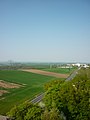
Since 2004, it has been open again as a lookout tower on weekends in the summer months. From the viewing platform, the view extends south over the entire city to the heights of the Ilm-Saale-Platte near Vierzehnheiligen . The Finnerücken and Eckartsburg can be seen to the northeast . To the west you can see the city of Weimar with the bell tower of the Buchenwald memorial , and when the visibility is good, the contours of the Thuringian Forest can also be seen.
Views

Looking north
Looking east

View over the city to the south

Looking west
Portrait relief of Otto von Bismarck
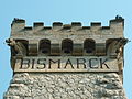
Lettering below the viewing platform

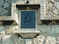
Memorial plaque at the entrance


literature
- The Apolda Peace Tower. In: Apoldaer Heimat , born in 1989.
- Otto von Bismarck, Bismarck Association and Bismarck Tower. In: Apoldaer Heimat , born in 2004.
- Eva Gollrad: History and description of the city of Apolda 1871–1990. Apolda o. J., ISBN 3-00-002012-8 .
- City of Apolda (ed.): The Bismarck Tower in Apolda. Apolda 2004.
- Sieglinde Seele: Lexicon of the Bismarck Monuments. Michael Imhof Verlag, Petersberg 2005, ISBN 3-86568-019-4 .
Web links
- Bismarckturm Apolda on www.bismarcktuerme.de
- Bismarck Tower Apolda on the website of the city of Apolda
- Klaus Jäger: Start of the season for the Bismarck Tower - the striking building with the viewing platform on Leipziger Strasse can celebrate its 114th birthday this year. Thüringer Allgemeine , online portal. Retrieved April 5, 2018 .
Individual evidence
- ↑ Klaus Jäger: Start of the season for the Bismarck Tower - the striking building with the viewing platform on Leipziger Strasse can celebrate its 114th birthday this year. Thüringer Allgemeine , online portal. Retrieved April 5, 2018 .
Coordinates: 51 ° 2 ′ 3.5 ″ N , 11 ° 30 ′ 14.8 ″ E