Blanchard (Town, Wisconsin)
| Blanchard | ||
|---|---|---|
|
Location in Wisconsin
|
||
| Basic data | ||
| State : | United States | |
| State : | Wisconsin | |
| County : | Lafayette County | |
| Coordinates : | 42 ° 48 ′ N , 89 ° 53 ′ W | |
| Time zone : | Central ( UTC − 6 / −5 ) | |
| Residents : | 264 (as of 2010) | |
| Population density : | 5.8 inhabitants per km 2 | |
| Area : | 45.4 km 2 (approx. 18 mi 2 ) | |
| Height : | 302 m | |
| Area code : | +1 608 | |
| FIPS : | 55-08100 | |
| GNIS ID : | 1582827 | |
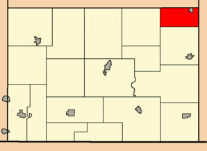
 Location of the Town of Blanchard in Lafayette County |
||
The Town of Blanchard is one of 18 Towns in Lafayette County in the US -amerikanischen State Wisconsin . In 2010 the Town of Blanchard had 264 residents.
Town has a fundamentally different meaning in Wisconsin than in the rest of the English-speaking area. Rather, it corresponds to the usual townships in the other US states , which form the next smaller administrative unit after the county .
geography
The Town of Blanchard is located in southwest Wisconsin, around 85 km east of the Mississippi , which forms the border with Iowa . The Illinois border is around 25 miles south. The east of the Town of Blanchard is traversed in a north-south direction by the Pecatonica River , a tributary of the Rock River which flows into the Mississippi .
On the northeastern edge of the Town of Blanchard is the independent community Blanchardville , which is almost completely surrounded by the town without belonging to it.
The coordinates of the geographical center of the Town of Blanchard are 42 ° 47'36 "north latitude and 89 ° 53'20" west longitude. It extends over an area of 45.4 km².
The Town of Blanchard is located in the far northeast of Lafayette County and borders the following neighboring towns:
|
Town of Waldwick ( Iowa County ) |
Town of Moscow (Iowa County) |
|
| Town of Fayette |

|
Town of York ( Green County ) |
|
Town of Argyle |
Town of Adams (Green County) |
traffic
The Wisconsin State Highway 78 runs through the Town of Blanchard in a north-south direction . In addition, the county highways F, H and N run through the town. All other roads are subordinate country roads or partly unpaved roads.
The nearest airports are Dubuque Regional Airport in Iowa (around 110 km west-southwest) and Dane County Regional Airport in Wisconsin's capital Madison (around 70 km northeast).
population
According to the 2010 census , the Town of Blanchard had 264 people in 98 households. The population density was 5.8 inhabitants per square kilometer. Statistically, there were 2.69 people each in the 98 households.
Ethnically, the population consisted only of whites with one exception. Regardless of ethnicity, 1.5 percent of the population was Hispanic or Latino of any race.
24.6 percent of the population were under 18 years old, 64.0 percent were between 18 and 64 and 11.4 percent were 65 years or older. 50.0 percent of the population was female.
The average annual income for a household was 39,643 USD . The per capita income was $ 20,618. 19.1 percent of the population lived below the poverty line.
Towns in the Town of Blanchard
In the area of the Town of Blanchard there are no other settlements besides scattered settlement.
Individual evidence
- ↑ a b American Fact Finder. Retrieved September 18, 2013
- ↑ Distance information according to Google Maps. Accessed on September 18, 2013
