Boardman Township (Iowa)
| Boardman Township | ||
|---|---|---|
![The Elkader Keystone Bridge over the Turkey River in Elkader, listed in the NRHP since 1976 [1]](https://upload.wikimedia.org/wikipedia/commons/thumb/f/f7/Elkader_Keystone_Bridge.jpg/298px-Elkader_Keystone_Bridge.jpg) The Elkader Keystone Bridge over the Turkey River in Elkader, listed in the NRHP since 1976 |
||
| Location in Iowa | ||
|
|
||
| Basic data | ||
| State : | United States | |
| State : | Iowa | |
| County : | Clayton County | |
| Coordinates : | 42 ° 52 ′ N , 91 ° 25 ′ W | |
| Time zone : | Central ( UTC − 6 / −5 ) | |
| Residents : | 1,684 (as of 2010) | |
| Population density : | 17.8 inhabitants per km 2 | |
| Area : | 94.41 km 2 (about 36 mi 2 ) | |
| Height : | 226 m | |
| Postal code : | 52043 | |
| Area code : | +1 563 | |
| FIPS : | 19-90291 | |
| GNIS ID : | 467471 | |
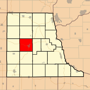
 Location of Boardman Township in Clayton County |
||
The Boardman Township is one of 22 townships in Clayton County in the northeast of the US -amerikanischen state of Iowa .
geography
Boardman Township is located in northeast Iowa on the Turkey River , a tributary of the Mississippi , which forms the border with Wisconsin around 30 km east . The border with Minnesota is around 100 km north, Illinois begins around 100 km southeast on the opposite bank of the Mississippi.
Boardman Township is located at 42 ° 52 ' N , 91 ° 25' W and extends over 94.41 km².
The Boardman Township borders within Clayton County in the north on the Wagner Township , in the northeast on the Farmersburg Township , in the east and southeast on the Read Township , in the south on the Cox Creek Township , in the southwest on the Sperry Township , in the west on the Highland Township and in the northwest to the Marion Township .
traffic
Iowa Highways 13 and 56 and a number of secondary roads meet in Boardman Township .
The Elkader Municipal Airport is located in the west of Boardman Township.
population
At the 2010 census , the township had 1,684 inhabitants.
Most of the population of Boardman Township is concentrated in Elkader , the only independent municipality (with " City " status ). Elkader is also the administrative seat of all of Clayton County.
Individual evidence
- ↑ Extract from the National Register of Historic Places - No. 76000747 Retrieved March 22, 2012
- ↑ Distance information according to Google Maps. Accessed on March 22, 2012
- ↑ Missouri Census Data Center - Iowa ( page no longer available , search in web archives ) Info: The link was automatically marked as defective. Please check the link according to the instructions and then remove this notice. Retrieved March 22, 2012
