Bolster long horn
| Bolster long horn | ||
|---|---|---|
|
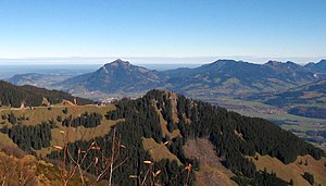
Bolsterlanger Horn in the center of the picture, in the background the Grünten |
||
| height | 1586.2 m above sea level NN | |
| location | Bavaria , Germany | |
| Mountains | Pre-Alps west of the Iller , Allgäu Alps | |
| Dominance | 0.6 km → Weiherkopf | |
| Notch height | 46 m ↓ notch to the Weiherkopf | |
| Coordinates | 47 ° 27 '34 " N , 10 ° 12' 30" E | |
|
|
||
| Type | Grasberg | |
| rock | Flysch | |
| First ascent | by locals | |
The Bolsterlanger Horn is a grass mountain peak in the Allgäu Alps in Bavaria . Since the 1586 meter high summit rises above the municipality of Bolsterlang , it is considered the local mountain of this place. The Bolsterlanger Horn belongs to the horn group , it is its southernmost elevation. The notch height of the Bolsterlanger Horn is at least 46 meters, its dominance 600 meters, with the Weiherkopf being the reference mountain . The summit was originally called Sonderdorfer Horn and was renamed Bolsterlanger Horn because of better tourist marketing.
Ascent
The normal route leads from the mountain station of the Hörnerbahn through a forest path to the summit in just ten minutes.
particularities
In 2009, the path to the summit from the Hörnerbahn was made into a path of reflection.
Summit cross
On the summit there is a cross with mirrors, which lights up brightly in the sunshine.
References and comments
- ↑ Exact value not known, stated value is a minimum value (can be up to 19 meters higher). It was determined from the distance between the contour lines (20 meters in altitude ) on a topographic map ( scale 1: 25,000).
- ^ Official map - digital local map 1:10 000. In: BayernAtlas. State Office for Digitization, Broadband and Surveying Bavaria , accessed on January 23, 2016 .

