Bongsieler channel
|
Bongsieler Kanal Kongecanal |
||
|
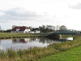
The Munksbrück over the Bongsiel Canal |
||
| Data | ||
| location | North Friesland | |
| River system | Bongsieler channel | |
| River basin district | Eider | |
| muzzle |
Schlüttsiel coordinates: 54 ° 40 ′ 56 ″ N , 8 ° 45 ′ 19 ″ E 54 ° 40 ′ 56 ″ N , 8 ° 45 ′ 19 ″ E
|
|
| length | 4.7 km | |
| Catchment area | 732 km² | |
| Communities | Dagebüll and Ockholm | |
The Bongsieler Kanal ( Danish Bongsilkanalen , formerly Kongecanal ) is a canal in North Friesland . The cyprinid water begins at the confluence of the Lecker Au and Soholmer Au at the level of the Bottschlotter Lake and ends at the Schlüttsiel pumping station . The last section of the route in the area of the Hauke-Haien-Koog , the so-called Neue Bongsieler Canal , forms the border between the communities of Dagebüll and Ockholm . It branches off from the old canal at the Amtmannseck pumping station . Until the Kooges was dyed at the end of the 1950s, the canal flowed into the North Sea at Bongsieler Sielhafen . The Bongsiel Canal belongs to the Eider river basin district .
Backwaters
The following waters are backwaters of the Bongsiel Canal.
| Water catchment area ≥ 10 km² | muzzle | AEo (km²) |
|---|---|---|
| Meyner Mühlenstrom | Left | 35,929 |
| Wallsbek | right | 27.928 |
| Spölbek | right | 20.601 |
| Rodau | Left | 54.357 |
| Linnau | Left | 72.188 |
| Goldebeker Mill Stream | Left | 39.240 |
| Little Au | Left | 46,602 |
| Südersielzug | Left | 16.876 |
| Delicious Au | right | 218,305 |
| Kornkoog / Maasbüller Herrenkoog drainage canal | right | 44.715 |
| Alte Soholmer Au / Hauptsielzug Langenhorn | Left | 26.734 |
| Sterdebüller main train | Left | 17,599 |
Web links
- Information on the water level at Schlüttsiel from the State Office for Coastal Protection
- Profile Bongsieler Kanal at schleswig-holstein.de
- Picture collection for the canal
Individual evidence
- ↑ Eider river basin district (PDF), accessed on April 2, 2018
- ↑ Jens Peter Trap: Statistisk-topographisk beskrivelse af hertugdømmet Slesvig, Volume 1, Kjøbenhavn 1864, p. 212
- ↑ Eider river basin district - report on the analyzes according to Article 5 of Directive 2000/60 / EC. (PDF; 2.6 MB) Retrieved April 2, 2018 .
