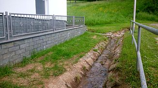
Borngraben (Kahl)
| Borngraben | ||
|
The Borngraben in Niedersteinbach |
||
| Data | ||
| location |
Spessart
|
|
| River system | Rhine | |
| Drain over | Kahl → Main → Rhine → North Sea | |
| source | east of Niedersteinbach between Herrenberg (343 m) and Steinküppel (326 m) 50 ° 4 ′ 57 ″ N , 9 ° 9 ′ 50 ″ E |
|
| Source height | approx. 250 m above sea level NHN | |
| muzzle | near the Strötzbacher Doppelmühle in the Kahl coordinates: 50 ° 4 ′ 51 ″ N , 9 ° 9 ′ 17 ″ E 50 ° 4 ′ 51 ″ N , 9 ° 9 ′ 17 ″ E |
|
| Mouth height | 157 m above sea level NHN | |
| Height difference | approx. 93 m | |
| Bottom slope | approx. 12% | |
| length | 750 m | |
| Catchment area | 48 ha | |
The Borngraben is a right tributary of the Kahl in the district of Aschaffenburg in the Bavarian Spessart .
geography
course
The Borngraben rises east of Niedersteinbach between the mountains Steinküppel (326 m) and Herrenberg (343 m). It runs west into the upper village of Niedersteinbach. The Borngraben used to flow into the Flitschgraben about 200 m further. This moat took up the brook from Buchborn and the brook from Hirschgraben and flowed into the Kahl southeast of the Niedersteinbach train station . Today the brook from Buchborn is a tributary of the Borngraben, which is then led directly into the Kahl near the Strötzbacher Mühle .
Tributaries
- Bach from Buchborn (left)
Kahl river system
See also
Web links
Commons : Borngraben (Kahl) - Collection of images, videos and audio files
Individual evidence
- ↑ a b c d BayernAtlas of the Bavarian State Government ( notes )
- ↑ Form for Our Kahlgrund 2018 . Homeland yearbook for the Alzenau district. Published by the working group for homeland research and homeland maintenance of the Alzenau district, district administrator. ISSN 0933-1328 . (Written by Hermann Kehrer, author of the Alzenauer Wetterchronik.)
