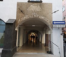
Bolzano arcades

The Bozen Lauben (also Laubengasse ; Italian : Via dei Portici ) are a sight of Bolzano , the capital of South Tyrol . They are considered to be the nucleus of the medieval city complex and are still the most important street in the old town, cutting it from east to west, from the town hall square to the fruit market .
history
The arbors were built in the late 12th century - in the late period of the reign of Emperor Frederick I Barbarossa - by the bishops of Trento as a typical street market with a central grain market (the Kornplatz ) and (abandoned) city castle. The bishops sought to create a trading center they controlled in the Bolzano basin, but control of which they had to quickly share with the Counts of Tyrol . During trade fairs, the Bolzano merchants rented their vaults - the old name of the arbors is documented as "under the vaults" as early as 1490 - to traders from the north and the south. The northern arcades were reserved for merchants from the south, the southern arbors for those from the north. Hence the older names " Welsche Lauben" and " Teutsche Lauben" . Some merchant families, such as the Fuggers , had their own offices under the arbors in Bozen.
The address and the rooms of the imperial purveyor to the court, Josef Ringler's sons , still exist today under the Lauben 7.
The replanning of Italian fascism for a largely italianisiertes "Greater Bolzano" saw in accordance with the land use plan by Marcello Piacentini in 1934 and the demolition of the entire northern deciduous line before, according to which after the road widening of the medieval, "German" architecture, an Italian-influenced buildings would be opposed should. Only the outbreak of war in 1939/40 prevented these measures.
Appearance and texture
The arbor houses are characterized by a characteristic architecture with multiple functions:
- On the ground floor there are the arcades on which the mercantile life took place, and behind them the so-called "vaults" in which the goods were stored.
- The apartments are located on the floors above, arranged around an inner courtyard , the so-called atrium, which should also bring daylight to the interior windows. Most of the time the stairs in this atrium have wrought iron railings .
The arbor apartments have a so-called “beautiful” front facing the arbor lane, while the rear rooms were reserved for the staff of the city patriciate . Even more interesting than the storeys are the cellars of the arcade houses, some of which date back to the late Romanesque era and in many cases were used to store the wine made in the Bolzano area . They are equipped with vaults and often extend two or three stories into the ground, which is due to the narrow width of the plots of just 3.6 meters. The walls, which are at the same time the foundations and have supported the houses for several centuries, are double-skinned: ventilation ducts allow fresh air to be supplied and keep the cellars mold-free . The city building authority paid little attention to the ventilation slots in the steps when paving the Laubengasse and partially concreted them over, so that as a result, quite a few cellars became damp and moldy.
Through the Laubengasse still flows today an underground water channel (in Bozen "Ritsch", formerly also called "Wiere" or "Nuesch"), which used to supply the arbor houses with usable water, but was also used for waste disposal and fire fighting (she can be recognized by the paving of the street).
The Dr.-Streiter-Gasse (north) and the Silbergasse (south) run parallel to the arbors on the former city moats ; they are connected to the arbors by several narrow crossways.
Information about the history of the arcades is provided by the tour through the underground Bolzano set up in the Mercantile Museum.
literature
- Josef Weingartner : The art monuments Bolzano . Vienna-Augsburg: Hölzel 1926, p. 143 ff. (Online)
Individual evidence
- ↑ See Hannes Obermair : Church and city development. The parish church of Bolzano in the High Middle Ages (11th – 13th centuries) (PDF; 2.6 MB). In: Der Schlern , Bozen 1995, esp.p. 459ff.
- ^ Hannes Obermair: Bozen Süd - Bolzano Nord. Written form and documentary tradition of the city of Bozen up to 1500 . tape 2 . City of Bozen, Bozen 2008, ISBN 978-88-901870-1-8 , p. 209, No. 1268 .
- ^ Association of Austrian Chemists (ed.): Österreichische Chemiker-Zeitung . tape 5-6 . Vienna 1891 ( Bolzano fruits and canned goods in the Google book search USA ).
- ↑ Sabrina Michielli, Hannes Obermair (Red.): BZ '18 –'45: one monument, one city, two dictatorships. Accompanying volume for the documentation exhibition in the Bolzano Victory Monument. Vienna-Bozen: Folio Verlag 2016. ISBN 978-3-85256-713-6 , p. 57.
- ↑ See Hannes Obermair, Helmut Stampfer : [1] (PDF; 39 kB) Urban living culture in late medieval Bolzano . In: Runkelstein Castle . The Bilderburg , ed. from the city of Bozen with the participation of the South Tyrolean Cultural Institute (cat.), Bozen 2000, pp. 397–409.
- ↑ Cf. Rainer Loose : Wohnen und Wirtschaften in der Laubengasse - An attempt at a social topography of the old town of Bozen around 1350 , in: Bozen from the Counts of Tyrol to the Habsburgs , Bozen 1999, pp. 105–126.
- ↑ The south of South Tyrol: The Bozen arcades
- ↑ Martin Mittermair and others: The medieval cellars of the mercantile building in Bozen - Le cantine medioevali di Palazzo Mercantile a Bolzano . Bolzano: Mercantile Museum Bolzano 2012.
- ^ Karl Theodor Hoeniger : The oldest Bolzano council minutes from 1469 . In: (Bozner) year book for history, culture and art, publishing house Vogelweider, Bozen 1934, p. 7–111, reference p. 61 ( Haus am Nuesch ).
Web links
Coordinates: 46 ° 29 ′ 58.7 " N , 11 ° 21 ′ 15.9" E


