Brandenberger Valley
| Brandenberger Valley | ||
|---|---|---|
|
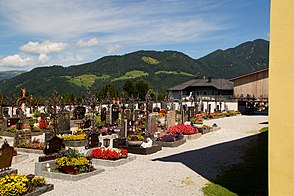
View over the St. Georg cemetery to the Brandenberger Oberberg |
||
| location | Tyrol , Austria | |
| Waters | Brandenberger Ache | |
| Mountains | Brandenberg Alps | |
| Geographical location | 47 ° 30 ' N , 11 ° 53' E | |
|
|
||
| height | 500 to 800 m above sea level A. | |
| length | 25 km | |
The Brandenberger Tal is a side valley of the Lower Inn Valley in Tyrol between the Sonnwendgebirge and Hinterem Sonnwendjoch , which branches off to the north near Kramsach . The Brandenberger Ache flows through it, which rises just behind the German border and flows into the Inn near Kramsach .
Characteristic of the wooded high valley are the many gorges , such as the Kaiserklamm near Aschau and the Tiefenbachklamm between Brandenberg and Kramsach, which were deeply cut by the Brandenberger Ache.
Settlements can only be found in basin-like extensions (the places Aschau and Pinegg) and on the slope ledges in the outer valley section (the main place Brandenberg ).
The valley was a center for the timber industry until the 20th century due to the abundance of forests, and since then tourism in particular has gained in importance. From the Middle Ages to 1966 there was one of the largest wooden drifts in Central Europe on the Brandenberger Ache , which the Archduke Johann Klause and the Triftsteige in the gorges still bear witness to today .
Web links
Individual evidence
- ^ Brandenberger Tal , aeiou.at
- ↑ Gorge hikes , alpbachtal.at


