Brautlach (river)
| Bride laugh | ||
|
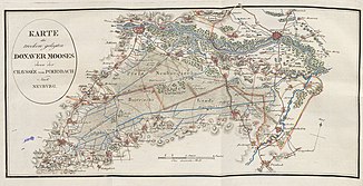
Map by Adrian von Riedl (1804–1805) |
||
| Data | ||
| Water code | DE : 13482 | |
| location | Bavaria | |
| River system | Danube | |
| Drain over | Sandrach → Paar (Danube) → Danube → Black Sea | |
| muzzle | north of Niederstimm in the Sandrach coordinates: 48 ° 43 ′ 41 ″ N , 11 ° 27 ′ 43 ″ E 48 ° 43 ′ 41 ″ N , 11 ° 27 ′ 43 ″ E |
|
| Mouth height | approx. 370 m above sea level NN
|
|
| length | 21.4 km | |
The Brautlach is a right tributary of the Sandrach near Niederstimm (Markt Manching ) in the Pfaffenhofen an der Ilm district in Bavaria. The length of the river is about 21 kilometers.
history
The Brautlach was originally a direct branch of the Danube , because the Sandrach was the southernmost of the three branches of the Danube in the area of Ingolstadt and at the same time the main arm. Around 1363 the northern of the three arms was expanded to the main arm for commercial reasons on the instructions of Duke Stephan II , by diverting the water from the southern arm to the northern one. The demarcation between the diocesan borders between the dioceses of Eichstätt and Augsburg , which still exists today , dates back to this time when the Sandrach marked the main arm of the Danube . For a long time the Sandrach and the Brautlach were also the border between the two duchies of Bavaria and Pfalz-Neuburg .
The original location on the Danube also explains that two Roman ships have been found in Oberstimm near the Brautlach. The two ships have been exhibited in the Celtic-Roman Museum in Manching since 2006 .
course
The headwaters of the Brautlach were originally on the natural overflow of the marshland in the east of the Donaumoos near Oberstimm . The water of today's Brautlach, however, comes from the drainage canals of the Donaumoos that were built in the 18th century. The main canal begins north of Berg im Gau and flows together with several small moss canals at the village of Brautlach . The river, now known as Breitlach, joins the military canal at Oberstimm and flows north of Niederstimm into the Sandrach , which finally flows into the Paar north of Manching .
Web links
- River landscape of the Ingolstadt Basin - arms of the Danube near Ingolstadt - (Ingolstadt City Museum)
- Donaumoosbach, Zucheringer Wörth and Brucker Forst - (District of Neuburg-Schrobenhausen)
Individual evidence
- ^ Bavarian State Office for the Environment: Directory of the brook and river areas in Bavaria . 2016.
- ↑ Barbara Pferdehirt: The Roman military ships from Oberstimm, Markt Manching , see Celtic-Roman Museum Manching .
- ^ Johann Georg von Aretin: Donaumoos-Kulturs-Geschichte Schwan und Göß, Mannheim, 1795.

