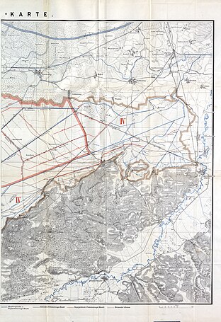
Old Bavarian Donaumoos
The Donaumoos is a lowland south of the Danube in Bavaria , in the triangle between Ingolstadt , Neuburg an der Donau and Pöttmes . Originally it was the largest Bavarian fen . It is not to be confused with the Swabian Donaumoos between Ulm and Gundelfingen and is therefore called "Old Bavarian Donaumoos" to distinguish it.
history


From 1796 the moor was drained, which represented the largest reclamation of new land in Bavaria since the Middle Ages. The Danube moss has almost completely lost its moor character due to the reclamation and the vegetation typical of low marshes has been largely displaced. Above all, drainage and agriculture, in addition to cutting peat, led to a significant lowering of the terrain and to significant soil erosion due to wind erosion . The ground sags by one to two centimeters every year. In the past 200 years, around 3 meters of peat has been lost over a large area .
Today there are still three Donaumoos communities:
The Donaumoos communities of Grasheim , Klingsmoos , Ludwigsmoos and Untermaxfeld , which had existed since the 19th century, lost their political independence in the course of the Bavarian regional reform in the 1970s.
Today the Donaumoos is mainly used as a potato growing area. Today one third of the original moor area of 180 km² is cultivated. The Federal Agency for Nature Conservation uses a more extensive landscape delimitation, according to which the Donaumoos landscape covers 593 km².
Donaumoos association
The Zweckverband (corporation under public law) founded in 1991 includes the district of Upper Bavaria , the district of Neuburg-Schrobenhausen , the communities of Karlshuld, Königsmoos and Karlskron, the Pöttmes market and the Donaumoos I – IV water associations. According to the statutes, it wants to contribute to the preservation of the Donaumoos as a rural settlement, economic and cultural area, to secure and improve the natural foundations of life, and to protect and develop the habitats of flora and fauna. The focus is primarily on measures relating to water management, nature conservation and landscape management, as well as technical coordination in the design of a “special Donaumoos program” and the establishment of an eco-land management system. In a development concept from 2000 to 2030, the association has set itself the following goals:
- Flood protection for the settlements
- sustainable agricultural use
- Protection of peat bodies in combination with species and biotope protection
The chairman of the special-purpose association is the district administrator.
Among other things, the development concept envisages increasing the proportion of grassland to over 50% by 2030 in order to counteract peat shrinkage and wind erosion. Sustainable use should primarily take place through grazing . For this purpose, the suitability of various livestock breeds is tested, including Murnau-Werdenfels cattle and moorland snouts . In 2003, a 25 was ha large bison -Gehege commissioned.
LAG Altbayerisches Donaumoos eV
The old Bavarian Donaumoos is also the name of a regional Leader action group. This is an amalgamation of all 18 municipalities in the Neuburg-Schrobenhausen district and the Hohenwart market in the Pfaffenhofen an der Ilm district.
The LAG “Altbayerisches Donaumoos e. V. ”has borrowed its name from the Donaumoos natural area, which is seen as creating identity within the framework of the LEADER + funding period . "Altbayerisches Donaumoos" describes a geographically coherent living, economic and social area with a jointly supported regional development. Almost 100,000 people live in the LAG area in a contiguous area of 850.89 km².
Donaumoos Foundation
The Donaumoos Foundation is responsible for the “ House in the Moos ” in the Kleinhohenried part of Karlshulder. It is a public foundation under civil law with legal capacity and was approved by the government of Upper Bavaria on August 19, 1997. The foundation operates an open-air museum with an environmental education center and conference center.
Individual evidence
- ^ The Donaumoos dies in: Bayerische Staatszeitung , December 12, 2014
- ↑ Walter Martin, Reinhard Jochum, Robert Traidl: Geology and Soils in Bavaria , in: Excursion Guide Munich 2015 ( DBG Mitteilungen Volume 117), ISSN 0343-1071 , p. 25 (PDF)
- ^ District office Neuburg-Schrobenhausen: Naturraum Donaumoos
- ↑ Landscape profile : 6300 Donaumoos
- ↑ The bison project in the Donaumoos at www.haus-im-moos.de
- ↑ Wisentgehege Donaumoos at www.wisentgehege-donaumoos.de
Web links
- Donaumoos association
- Local action group Altbayerisches Donaumoos
- Donaumoos Foundation
- Stefan Mayr: Doomed , article in the Süddeutsche Zeitung from November 3, 2015
Coordinates: 48 ° 39 ′ 59.8 ″ N , 11 ° 13 ′ 0 ″ E


