Briceni
|
Briceni ( rum. ) Бричаны ( Russian ) |
|||
|
|||
| State : |
|
||
| Administrative unit : | Briceni district | ||
| Founded : | 1562 | ||
| Coordinates : | 48 ° 22 ′ N , 27 ° 5 ′ E | ||
| Height : | 220 m. ü. M. | ||
| Area : | 5.13 km² | ||
| Residents : | 9,900 (2014) | ||
| Population density : | 1,930 inhabitants per km² | ||
| Telephone code : | +373 247 2 | ||
| Postal code : | MD-4700 | ||
| Mayor : | Mihail Gnatiuc | ||
|
|
|||
Briceni (in Cyrillic Бричень, Russian Бричаны , Ukrainian Бричани ) is a small town in the far north of the Republic of Moldova on the Ukrainian border. It is the administrative seat of the Briceni district and is located on the Lopatinka brook , which is artificially dammed here.
population
In the last Moldovan census in 2004, the city had 8,765 inhabitants. Of these, 4,271 identified themselves as Ukrainians (48.7%), 3,411 as Moldovans (38.9%), 737 as Russians (8.4%), 185 as Gypsies and 52 as Jews .
In 1930 of the 5,625 inhabitants of the city of Briceni (Briceni Târg), 5,346 were Jews (95.2%), who almost without exception stated Yiddish as their mother tongue. The city thus had one of the largest Jewish communities in Bessarabia and had, among other things, a synagogue, several Jewish schools and a Jewish hospital.
On July 8, 1941, Briceni, which had been under Soviet administration since the previous year, was occupied by German and Romanian troops. As a result, at the end of July, all Jews - almost the entire population - were driven behind the Dniester and thus out of Bessarabia, and most of them were murdered. After the war, only 1,000 Jews returned to Briceni.
Attractions
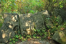
The Jewish cemetery has around 5,000 tombstones and is now largely overgrown with vegetation, but overall it is relatively well preserved. It is located at the eastern exit of the city on the left side of the R11 road leading to Ocnița .
traffic
There is a small international border crossing to Ukraine three kilometers northwest of the city center. The M14 trunk road leads south to the capital Chișinău, 240 kilometers away, and to the west also to a Moldovan-Ukrainian border crossing and on to Chernivtsi .
Twin cities
Web links
Individual evidence
- ↑ Numărul preliminar al populaţiei stable în Republica Moldova la January 1st 2014 . National bureau of statistics of the Republic of Moldova. Archived from the original on April 26, 2015. Info: The archive link has been inserted automatically and has not yet been checked. Please check the original and archive link according to the instructions and then remove this notice. Retrieved August 28, 2019.


