Bruckbach (Leitzach, Fischbachau)
| Bruckbach | ||
|
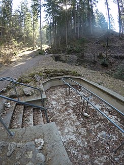
Kneipp facility on the Bruckbach above the Schwaigeralm |
||
| Data | ||
| location |
Northern Limestone Alps
|
|
| River system | Danube | |
| Drain over | Leitzach → Mangfall → Inn → Danube → Black Sea | |
| source | below the Bucher Alm 47 ° 43 ′ 29 ″ N , 11 ° 58 ′ 25 ″ E |
|
| Source height | approx. 1133 m above sea level NHN | |
| muzzle | to Point from the right in the Leitzach coordinates: 47 ° 47 '34 " N , 11 ° 52' 59" E 47 ° 47 '34 " N , 11 ° 52' 59" E |
|
| Mouth height | 650 m above sea level NHN | |
| Height difference | approx. 483 m | |
| Bottom slope | approx. 15% | |
| length | approx. 3.2 km | |
The Bruckbach is a flowing body of water in the Mangfall Mountains . It arises below the Bucher Alm and flows through a ditch near the Schwaigeralm. There is an old Kneipp facility there. After a further course it flows into channels near the Leitzach, which are used for pond irrigation.
Individual evidence
- ↑ a b Height queried (with a right click) on: BayernAtlas of the Bavarian State Government ( information )
- ↑ Length measured on: BayernAtlas of the Bavarian State Government ( notes )
