
Brunnbach (Hagertal)
| Brunnbach | ||
 Brunnbachfall at the Bäckenalm |
||
| Data | ||
| Water code | AT : 2-8-270-94 | |
| location | Kitzbühel District , Tyrol , Austria | |
| River system | Danube | |
| Drain over | Großache → Alz → Inn → Danube → Black Sea | |
| source | on Fellhorn 47 ° 36 '47 " N , 12 ° 30' 13" E |
|
| Source height | 1610 m above sea level A. | |
| muzzle | in the Großache im Hagertal Coordinates: 47 ° 38 ′ 9 ″ N , 12 ° 27 ′ 32 ″ E 47 ° 38 ′ 9 ″ N , 12 ° 27 ′ 32 ″ E |
|
| Mouth height | 608 m above sea level A. | |
| Height difference | 1002 m | |
| Bottom slope | 17% | |
| length | 5.8 km | |
| Catchment area | 8.96 km² | |
| Communities | Kirchdorf in Tirol , Kössen | |
The Brunnbach is a body of water in the Hefferthorn-Fellhorn-Sonnenberg nature reserve in Tyrol (Austria).
Source and history
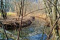
It rises at an altitude of 1610 m below the Fellhorn in the Chiemgau Alps and reaches the valley via several waterfalls in the Kreuzangergraben. The stream is additionally fed by tributaries from the Eggenalm via the Hasenauer Alm. In a last waterfall above the Bäckalm (now Einfangalm) the water falls again and collects in a lagoon-like basin.
From there the torrent winds its way north. It receives further tributaries from the trenches of the Einfangalm, the Hackalm, the Martenalm and the Weissensteinalm. In the Hagertal between Kössen and Kirchdorf in Tirol it flows into the Großache after two kilometers as a right tributary .
Quirks
The peculiarity of this body of water lies in the originality of the winding course and the natural vegetation on the banks. The natural stream is between 2 and 6 meters wide. When there is increased rainfall, the water swells quickly and shallowly overflows its banks, but flows through the windings at low speed. This creates the typical fertile floodplain here. In very severe winters (2018), the waterfall at the Einfangalm (Bäckalm) almost completely freezes and there is no surface water to be seen.
Surname
In the historical maps up to 1860 it was still listed as “Brunnen Bach”, but “Brunnbach” is now common both in language usage and in the Tyrolean regional planning registers.

Brunnbach in the Shire
Brunnbach in the Hagertal

Auwiesen am Brunnbach


