Brunton (Fife)
| Brunton | ||
|---|---|---|
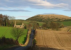
| Ruins of the old parish church; Brunton is largely obscured by trees | ||
| Coordinates | 56 ° 23 ′ N , 3 ° 6 ′ W | |
|
|
||
| Residents | 34 2001 census | |
| administration | ||
| Post town | CUPAR | |
| ZIP code section | KY15 | |
| prefix | 01337 | |
| Part of the country | Scotland | |
| Council area | Fife | |
| British Parliament | North East Fife | |
| Scottish Parliament | North East Fife | |
Brunton is a hamlet in the Scottish council area of Fife . It is tucked away in a valley in the hilly surroundings about seven kilometers northwest of Cupar and ten kilometers southwest of Dundee near the south bank of the Firth of Tay .
history
The remains of a hill fort and an Iron Age settlement can be found on the Green Craig hill northeast of Brunton . Their use is assumed between the years 500 before and 500 after our era. Another fort was located on Norman's Law, southwest of the village. The Tower House Creich Castle to the east is believed to date from the 16th century.
Brunton developed with weaving during the 18th and 19th centuries. There was also a flour mill nearby. In 1843 a church of the Free Church was built. Today it is mainly commuters who live in Brunton. In 2001 34 people lived there.
traffic
Brunton is connected to the road network via an unclassified secondary road. Within a few kilometers, however, the A92 ( Dunfermline - Stonehaven ) is accessible, through which there is a connection to Dundee via the Tay Road Bridge . It crosses the A913 (Cupar– Aberargie ) southwest of Brunton .


