
Bruny Island
| Bruny Island | ||
|---|---|---|
 |
||
| Waters | Tasman Sea | |
| Geographical location | 43 ° 17 ′ S , 147 ° 21 ′ E | |
|
||
| length | 51.4 km | |
| width | 20.9 km | |
| surface | 362 km² | |
| Highest elevation |
Mt Mangana 571 m |
|
| Residents | 600 1.7 inhabitants / km² |
|
| main place | Alonnah | |
 looking south |
||

Bruny Island is an island located southeast of Tasmania , Australia , and separated from the main island by the D'Entrecasteaux Canal . Both the canal and the island are named after the French explorer Joseph Bruny d'Entrecasteaux . In 1918 the spelling "Bruni" was changed to "Bruny".
geography
Bruny Island consists of two islands, North and South Bruny, which are only connected by a raffle called "The Neck". The island has an area of 362 km². The highest point is Mt. Mangana with 571 m. The island has about 600 inhabitants - that is 1.6 inhabitants per square kilometer. In the tourist season, however, there are up to 10,000 tourists.
The southernmost part of the island is occupied by the South Bruny National Park. Bruny Iceland have done particularly well known the resident Albino - wallabies (small kangaroos types of) that have proliferated due to lack of natural enemies on parts of the island. The island is covered with pastures and large areas of dry eucalyptus forest, which outside the national park are also used for the timber industry. The side of the island facing the open sea ( Tasman Sea ) has two long sandy beaches in the bays Adventure Bay (12 + 4 km long) and Cloudy Bay (about 6 km) in addition to a few smaller ones . The rest of the coastline is rather rugged with dolerite rocks up to 200 meters high. It is one of the highest cliffs in Australia. The side facing the mainland is largely protected from the influences of the high seas and is popular with anglers and sailors.
The island can only be reached via a car ferry from Kettering , which has been operated by the Tasmanian state since 1954. The ship Mirambeena , which is powered by a Voith-Schneider propeller, is currently used for this purpose . The ferry service departs from the Kettering Ferry Terminal and ends after about two nautical miles in the Maurice Dillon Terminal, not far from Roberts Point on Bruny Island.
history
The island was initially inhabited by Tasmanians , who called them Lunawanna-allonah , a name that lives on in two place names on the island, Alonnah and Lunawanna . Together with Adventure Bay , these are the main locations on the South Island.
Already Abel Tasman tried in November 1642 to land on the island. Tobias Furneaux went ashore here in 1773 and gave Adventure Bay its name. In 1777, James Cook followed , who carved his initials into a tree that was only destroyed in a bush fire in 1905 . Even William Bligh anchored four times here, including the end of August 1788 the Bounty , just before the famous mutiny. But only Bruni d'Entrecasteaux proved in 1792 that it was a separate island and not part of Tasmania. Nicolas Baudin used Barnes Bay as a base for his exploration of the D'Entrecasteaux Canal and southern Tasmania in 1802.
The Cape Bruny lighthouse , which was built by convicts in 1838, is an important testimony to the island's maritime history . It was the longest-running lighthouse in Australia and is now a cultural monument under the administration of South Bruny National Park .
Politically, the island today belongs to the Kingborough Council together with the town of Kettering on Tasmania . From Kettering you can take a ferry to Roberts Point in the north of Bruny Island in 15 minutes . Only the main road on the island is paved.
economy
The main industry today is tourism. The island has numerous summer guests as well as the weekend homes of Hobart citizens. The island's beaches and waters are popular for swimming, surfing, and sailing. The d'Entrecasteaux Channel offers a sea area shielded from the Pacific Ocean. Bruny itself has excellent anchorages, including at Barnes Bay, Simmonds Bay, Missionary Bay and Little Taylors Bay.
Bruny Island has the southernmost pub in Australia with a license to sell alcohol. In addition, the southernmost Australian wine-growing region (Bruny Island Premium Wines) is located here in Lunawanna .
photos
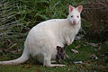
Albino Wallaby in Adventure Bay
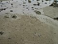
Mictyris / "Soldier crabs" on the beach
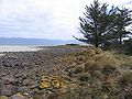
Beach on the east side of the island on the D'Entrecasteaux Canal
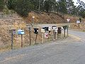
Because of the sparse population on the island, the postman cannot come to every house: mailbox collection on the main street


swell
- Bruny Island - English language Wikipedia
- own tour March 2009
- NN: Tasmania's Pristine South 2009 . Ed .: Houn Valley News, p. 28.
- Cruising Yacht Club of Tasmania (Ed.): D'Entrecasteaux Waterways, undated (Hobart), undated ISBN 0-72462336-1
Individual evidence
- ^ Bruny Island . Britannica Online. Retrieved June 7, 2009.
- ↑ Brendan Lowry and Trish Kearney . The Real Seachange. Retrieved June 7, 2009.
Web links
- Bruny Island Official Website - official website of Bruny Island Tourism.
- Bruny Island Tourist Information Guide - accommodation and visitor information
- Bruny Island Information Guide - Accommodation and visitor information including Ferry information.
- Link catalog on Bruny Island at curlie.org (formerly DMOZ ) has links to Bruny Island businesses and information.