
Buendía (Cuenca)
| Buendía municipality | |||
|---|---|---|---|
 Buendía - rest of the city walls
|
|||
| coat of arms | Map of Spain | ||
.svg)
|
|
||
| Basic data | |||
| Autonomous Community : |
|
||
| Province : | Cuenca | ||
| Comarca : | La Alcarria | ||
| Coordinates | 40 ° 22 ′ N , 2 ° 45 ′ W | ||
| Height : | 690 msnm | ||
| Area : | 88.5 km² | ||
| Residents : | 400 (Jan. 1, 2019) | ||
| Population density : | 4.52 inhabitants / km² | ||
| Postal code : | 16512 | ||
| Municipality number ( INE ): | 16041 | ||
| administration | |||
| Website : | Buendía | ||

Buendía is a place and a central Spanish municipality ( municipio ) with only 400 inhabitants (as of January 1, 2019) in the north of the province of Cuenca in the autonomous region of Castile-La Mancha . Buendía is part of the cultural landscape of the Alcarria and the Serranía Celtibérica, which is affected by ongoing population decline .
Location and climate
The place Buendía is on the west side of the Iberian Mountains at an altitude of approx. 690 m . The nearby Buendía reservoir was named after the place. The provincial capital Cuenca is a good 80 km (driving distance) to the southeast. The climate in winter is temperate, while in summer it is warm to hot; the rather low amounts of precipitation (approx. 490 mm / year) fall - with the exception of the almost rainless summer months - distributed over the whole year.
Population development
| year | 1857 | 1900 | 1950 | 2000 | 2019 |
| Residents | 1,586 | 1,423 | 1,890 | 491 | 400 |
Due to the mechanization of agriculture , the abandonment of small farms and the resulting loss of jobs in the countryside, the number of inhabitants in the municipality has declined sharply since the middle of the 20th century ( rural exodus ).
economy
For centuries the town's economy was largely self-sufficient ; Surplus cheese and sausages as well as animal skins and wool could be sold to traveling traders or exchanged for other products.
history
There is no evidence of settlement in the Celtic , Roman or Visigothic periods. During the Caliphate (929-1031) the area belonged to the Cora de Santaver sub-area . The place and its surroundings even during the reconquest probably were ( reconquista ) of Toledo in the late 11th century by the troops of Alfonso VI. taken. Perhaps already at this time, but at the latest after the reconquest of the city of Cuenca (around 1177), a policy of repopulation ( repoblación ) by Christians from all parts of the Iberian Peninsula began .
Attractions
- The place has a medieval appearance in parts. The center is the Plaza de los dos plazas with the arcaded town hall (ayuntamiento) .
- The Iglesia de Nuestra Señora de la Asunción , an imposing three-aisled hall church from the 16th century with star vaults, can be entered through the north portal .
- In the Casa Tercia , a former granary (posito) , there is a carriage museum .
- Surroundings
- A circular hiking trail ( Ruta de las Caras ) leads past around 20 heads and other monuments carved into the rock by various artists to the Buendía reservoir.
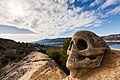
Skull at the reservoir

Dama de los Pantanos

"The Wizard's Spiral"


Web links
Individual evidence
- ↑ Cifras oficiales de población resultantes de la revisión del Padrón municipal a 1 de enero . Population statistics from the Instituto Nacional de Estadística (population update).
- ^ Buendía - population development
- ^ Buendía - town center
- ^ Buendía - Carriage Museum
- ↑ Buendía - Ruta de las Caras
Abia de la Obispalía | El Acebrón | Alarcón | Albaladejo del Cuende | Albalate de las Nogueras | Albendea | La Alberca de Záncara | Alcalá de la Vega | Alcantud | Alcázar del Rey | Alcohujate | Alconchel de la Estrella | Algarra | Aliaguilla | La Almarcha | Almendros | Almodóvar del Pinar | Almonacid del Marquesado | Altarejos | Arandilla del Arroyo | Arcas del Villar | Arcos de la Sierra | Arguisuelas | Arrancacepas | Atalaya del Cañavate | Barajas de Melo | Barchín del Hoyo | Bascuñana de San Pedro | Beamud | Belinchón | Belmonte | Belmontejo | Beteta | Boniches | Buciegas | Buenache de Alarcón | Buenache de la Sierra | Buendía | Campillo de Altobuey | Campillos-Paravientos | Campillos-Sierra | Campos del Paraíso | Canalejas del Arroyo | Cañada del Hoyo | Cañada Juncosa | Cañamares | El Cañavate | Cañaveras | Cañaveruelas | Cañete | Cañizares | Carboneras de Guadazaón | Cardenete | Carrascosa | Carrascosa de Haro | Casas de Benítez | Casas de Fernando Alonso | Casas de Garcimolina | Casas de Guijarro | Casas de Haro | Casas de los Pinos | Casasimarro | Castejón | Castillejo de Iniesta | Castillejo-Sierra | Castillo de Garcimuñoz | Castillo-Albaráñez | Cervera del Llano | La Cierva | Cuenca | Cueva del Hierro | Chillarón de Cuenca | Chumillas | Enguídanos | Fresneda de Altarejos | Fresneda de la Sierra | La Frontera | Fuente de Pedro Naharro | Fuentelespino de Haro | Fuentelespino de Moya | Fuentenava de Jábaga | Fuentes | Fuertescusa | Gabaldón | Garaballa | Gascueña | Graja de Campalbo | Graja de Iniesta | Henarejos | El Herrumblar | La Hinojosa | Los Hinojosos | El Hito | Honrubia | Hontanaya | Hontecillas | Horcajo de Santiago | Huélamo | Huelves | Huérguina | Huerta de la Obispalía | Huerta del Marquesado | Huete | Iniesta | Laguna del Marquesado | Lagunaseca | Landed | Ledaña | Leganiel | Las Majadas | Mariana | Masegosa | Las Mesas | Minglanilla | Mira | Monreal del Llano | Montalbanejo | Montalbo | Monteagudo de las Salinas | Mota de Altarejos | Mota del Cuervo | Motilla del Palancar | Moya | Narboneta | Olivares de Júcar | Olmeda de la Cuesta | Olmeda del Rey | Olmedilla de Alarcón | Olmedilla de Eliz | Osa de la Vega | Pajarón | Pajaroncillo | Palomares del Campo | Palomera | Paracuellos | Paredes | La Parra de las Vegas | El Pedernoso | Las Pedroñeras | El Peral | La Peraleja | La Pesquera | El Picazo | Pinarejo | Pineda de Gigüela | Piqueras del Castillo | Portal Rubio de Guadamejud | Portilla | Poyatos | Pozoamargo | Pozorrubielos de la Mancha | Pozorrubio | El Pozuelo | Priego | El Provencio | Puebla de Almenara | Puebla de Don Francisco | Puebla del Salvador | Quintanar del Rey | Rada de Haro | Reíllo | Rozalén del Monte | Saceda-Trasierra | Saelices | Salinas del Manzano | Salmeroncillos | Salvacañete | San Clemente | San Lorenzo de la Parrilla | San Martín de Boniches | San Pedro Palmiches | Santa Cruz de Moya | Santa María de los Llanos | Santa María del Campo Rus | Santa María del Val | Sisante | Solera de Gabaldón | Sotorribas | Talayuelas | Tarancón | Tébar | Tejadillos | Tinajas | Torralba | Torrejoncillo del Rey | Torrubia del Campo | Torrubia del Castillo | Tragacete | Tresjuncos | Tribaldos | Uclés | Uña | Los Valdecolmenas | Valdemeca | Valdemorillo de la Sierra | Valdemoro-Sierra | Valdeolivas | Valdetórtola | Las Valeras | Valhermoso de la Fuente | Valsalobre | Valverde de Júcar | Valverdejo | Vara de Rey | Vega del Codorno | Vellisca | Villaconejos de Trabaque | Villaescusa de Haro | Villagarcía del Llano | Villalba de la Sierra | Villalba del Rey | Villalgordo del Marquesado | Villalpardo | Villamayor de Santiago | Villanueva de Guadamejud | Villanueva de la Jara | Villar de Cañas | Villar de Domingo García | Villar de la Encina | Villar de Olalla | Villar del Humo | Villar del Infantado | Villar y Velasco | Villarejo de Fuentes | Villarejo de la Peñuela | Villarejo-Periesteban | Villares del Saz | Villarrubio | Villarta | Villas de la Ventosa | Villaverde y Pasaconsol | Víllora | Vindel | Yémeda | Zafra de Záncara | Zafrilla | Zarza de Tajo | Zarzuela