Albalate de las Nogueras
| Albalate de las Nogueras municipality | ||
|---|---|---|
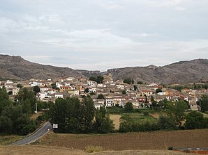
 Albalate de las Nogueras - town view
|
||
| coat of arms | Map of Spain | |

|
|
|
| Basic data | ||
| Autonomous Community : |
|
|
| Province : | Cuenca | |
| Comarca : | La Alcarria | |
| Coordinates | 40 ° 22 ′ N , 2 ° 17 ′ W | |
| Height : | 830 msnm | |
| Area : | 40.11 km² | |
| Residents : | 253 (Jan. 1, 2019) | |
| Population density : | 6.31 inhabitants / km² | |
| Postal code : | 16841 | |
| Municipality number ( INE ): | 16005 | |
| administration | ||
| Website : | Albalate de las Nogueras | |
Albalate de las Nogueras ( Arabic البلاط, DMG al-balāṭ = "way" / Spanish noguera = "walnut") is a place and a municipality ( municipio ) with only 253 inhabitants (as of January 1, 2019) in the northwest of the province of Cuenca in the autonomous region of Castile- La Mancha . The place is located on the Ruta de la Lana , a once important trade and pilgrimage route that - coming from Alicante or Valencia - led to Burgos . In addition, it belongs to the Serranía Celtibérica, which is suffering from severe population decline .
Location and climate
The place Albalate de las Nogueras is located at the confluence of the Río Albalate in the Río Trabaque on the west side of the Iberian Mountains at an altitude of about 830 m . The provincial capital Cuenca is about 42 km (driving distance) north. The climate in winter is temperate, while in summer it is warm to hot; the rather low amounts of precipitation (approx. 515 mm / year) fall - with the exception of the almost rainless summer months - distributed over the whole year.
Population development
| year | 1857 | 1900 | 1950 | 2000 | 2019 |
| Residents | 1.004 | 976 | 924 | 378 | 253 |
Due to the mechanization of agriculture , the abandonment of small farms and the resulting loss of jobs in rural areas, the number of inhabitants in the municipality has declined sharply since the middle of the 20th century ( rural exodus ).
economy
For centuries the town's economy was largely self-sufficient ; Surpluses could be sold to traveling dealers or exchanged for other products. Today viticulture plays an essential role in the economic life of the municipality.
history
Finds suggest a settlement in Celtic and Roman times; from the Islamic-Moorish period, the foundation walls of a mosque were discovered below the present church. One must therefore assume that the area was populated by Berbers in the 10th to 12th centuries . The situation changed after the reconquest ( reconquista ) of the city of Cuenca and its surrounding region by the troops of Alfonso VIII. Of Castile in 1177 and the subsequent policy of resettlement ( repoblación ) by Christians from all over the Iberian Peninsula .
Attractions
- The western part of the Iglesia de la Asunción with its precise stone work is considered an early testimony to the Romanesque in the region around Cuenca. The unadorned and portal-free facade is raised by a three-part bell gable (espadaña) ; only a narrow west window with inserted pillars indicates the construction time. The two late Romanesque - early Gothic portals of the church are on the north and south sides; the inner archivolt of the older north portal shows a zigzag decoration . There are several stone consoles (canecillos) below the eaves . The interior shows slightly sharpened barrel vaults with corresponding belt arches . The entire east part of the church was renewed in the 17th century. The church has an impressive Romanesque baptismal font with braided ribbon and rope decoration .
- Two wells (fuentes) with attached drinking troughs (abrevaderos) are inserted into the streets of the town.
- Several cellar vaults ( bodegas ) driven into the hill served as storage rooms for wine and other food.
- Surroundings
- To the north of the village, a two-arched medieval stone bridge leads over the Río Trabaque, whose gorge, located about 10 km to the north, offers delightful views.
literature
- Ricardo Blanco Niño: Albalate de las Nogueras. Perfiles de su historia. 1993, ISBN 84-604-7051-2 .
Web links
- Albalate de las Nogueras - Photos + Info (Spanish)
Individual evidence
- ↑ Cifras oficiales de población resultantes de la revisión del Padrón municipal a 1 de enero . Population statistics from the Instituto Nacional de Estadística (population update).
- ↑ Albalate de las Nogueras - Ruta de la Lana
- ↑ Albalate de las Nogueras / Cuenca - climate tables
- ^ Albalate de las Nogueras - population development
- ↑ Albalate de las Nogueras - Church
- ↑ Albalate de las Nogueras - Church


