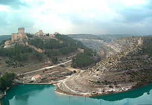
Alarcón (Spain)
| Alarcón municipality | ||
|---|---|---|

|
||
| coat of arms | Map of Spain | |

|
|
|
| Basic data | ||
| Autonomous Community : | Castile-La Mancha | |
| Province : | Cuenca | |
| Coordinates | 39 ° 35 ′ N , 2 ° 5 ′ W | |
| Height : | 831 msnm | |
| Area : | 119.96 km² | |
| Residents : | 148 (Jan. 1, 2019) | |
| Population density : | 1.23 inhabitants / km² | |
| Municipality number ( INE ): | 16003 | |
| administration | ||
| Website : | www.cuenca.es | |
Alarcón is a medieval village in the province of Cuenca , perched on a mountain on the bends of the Júcar River . The townscape is determined by a well-preserved Arab fortress and castle from the 8th century, which dates from the time of the Reconquista . Parts of the castle are used today as a state-run Parador .
geography
The municipality is located 87 kilometers south of Cuenca at an altitude of 881 meters.
Attractions
- Castillo de Alarcón
- Plaza de Don Manuel
- Santo Domingo de Silos church from the 13th century
- San Juan Bautista Church from the 16th century
- Holy Trinity Church from the 13th and 16th centuries
- Santa Maria Church from the early 16th century
Personalities associated with the place
- Alfonso VIII (Castile) , King of Castile
- Juan Ruiz de Alarcón , playwright
- Don Juan Manuel , statesman and writer
Web links
Commons : Alarcón - collection of images, videos and audio files
Individual evidence
- ↑ Cifras oficiales de población resultantes de la revisión del Padrón municipal a 1 de enero . Population statistics from the Instituto Nacional de Estadística (population update).
- ↑ Parador von Alarcón ( Memento of the original from April 2, 2010 in the Internet Archive ) Info: The archive link was inserted automatically and has not yet been checked. Please check the original and archive link according to the instructions and then remove this notice.
