Burgberg (Bad Laasphe)
| Castle Hill
(Castle)
|
||
|---|---|---|
|
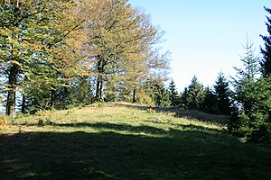
View to the Burgberg summit |
||
| height | 563.2 m above sea level NHN | |
| location | near Bad Laasphe ; District of Siegen-Wittgenstein , North Rhine-Westphalia ( Germany ) | |
| Mountains | Rothaar Mountains | |
| Coordinates | 50 ° 53 '7 " N , 8 ° 20' 19" E | |
|
|
||
| particularities | Hesselbacher Wallburg | |
The castle hill , also called castle , in the urban area of Bad Laasphe in the North Rhine-Westphalian district of Siegen-Wittgenstein is 563.2 m above sea level. NHN high mountain in the Rothaar Mountains .
geography
location
The Burgberg rises in the southern part of the Rothaargebirge and in the southeast of the Sauerland-Rothaargebirge nature reserve . Its summit is 1.6 km northwest of Fischelbach , 2.1 km west of Hesselbach and 1.9 km southeast of Bernshausen , all of which belong to Bad Laasphe. A nameless stream flows past to the north and the Gonderbach to the south , both of which flow into the Banfe near the mountains .
Natural allocation
The Burgberg belongs in the natural spatial main unit group Süderbergland (No. 33) and in the main unit Rothaargebirge (with Hochsauerland) (333) to the subunit Südwittgensteiner Bergland ( Wittgensteiner Lahnbergland ; 333.2). The landscape leads to the west into the natural area Ederkopf-Lahnkopf-ridge (333.01).
Mountain height
The castle hill is 563.2 m high. In the vicinity of the summit, the height indication "558.3" can be found on topographic maps and a trigonometric point at 555.3 m height about 60 m east-southeast of this point .
Landscape protection
Parts of the Bad Laasphe landscape protection area ( CDDA no. 555558490; designated 1987; 122.9381 km² ) are located on the Burgberg .
Hesselbacher Wallburg
On the summit region of the castle hill was the Hesselbacher Wallburg , which was built by the Celts or Teutons . The construction and use of the complex, which is surrounded by a ring wall, is dated to the La Tène period or the third century BC . Its egg-shaped interior is 250 m long and 120 m wide.
Individual evidence
- ↑ a b c d e Map services of the Federal Agency for Nature Conservation ( information )
- ^ Gerhard Sandner: Geographical land survey: The natural space units on sheet 125 Marburg. Federal Institute for Regional Studies, Bad Godesberg 1960. → Online map (PDF; 4.9 MB)
- ↑ Topographical Information Management, Cologne District Government, Department GEObasis NRW ( Notes )

