
Wolfsbach Castle Stables
| Wolfsbach Castle Stables | ||
|---|---|---|
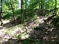
 Burgstall Wolfsbach today |
||
| Creation time : | around 1100 (first documented mention) | |
| Castle type : | Hilltop castle | |
| Conservation status: | Burgstall, remains of the wall | |
| Place: | Neubodendorf , municipality of Katsdorf | |
| Geographical location | 48 ° 18 '46.8 " N , 14 ° 29' 20.2" E | |
|
||

The Postal Wolfsbach is an Outbound hilltop castle in the district Neubodendorf the municipality Katsdorf in the district Perg in Upper Austria.
history
The castle is named after the Wolfsbach flowing past below. Excavations by Franz Gindlstrasser, Alfred Höllhuber and Leopold Mayböck indicate that the castle hill had been inhabited since the Stone Age.
The castle is said to have been the seat of the high freedians of Chazilinisdorf, but little is known about this family. In the tradition code of the Suben monastery around 1035, a chazili or an advocatus chazilinus is mentioned. Likewise, the name Chazilie or Chazile is often mentioned in the tradition code of the St. Nikola monastery of Passau . In 1125, the Passau bishop Reginmar confirmed a donation from the heriman de chazilinistdorf to the St. Florian monastery . This family had the first church built in Katsdorf, which was consecrated in 1116 by Bishop Udalrich I of Passau . The names of the Lords of Katsdorf appear several times as witnesses in various documents; In 1159 a herman de chazelinistorf witnessed an exchange agreement between the Wilhering monastery and the St. Peter monastery , around 1170 a marquardurs de Kazilinisdorf testified to a donation to the Aldersbach monastery .
The medieval finds from Burgplatz date from the late 11th to the 12th centuries. It remains uncertain when the castle fell. The Lords of Katsbach are also no longer mentioned after 1170.
Burgstall Wolfsbach today

In 1984 excavations took place on the castle hill with the support of the owner of the Neuwirthgut, Josef Gusenbauer. Parts of a Romanesque castle wall made of small stone blocks came to light. The outside of the moat consisted of a wall of loamy sand. According to the remains of the wall, the castle must have been 40 by 20 meters. Part of the castle has come off a quarry. The current stock measures around 25 by 17 m. The Palas is suspected in the southwest corner above a steep rocky slope. There was probably a square keep on the northeast corner . There were other buildings within the defensive walls (e.g. a horse stable). The remains of the wall still show a castle wall and an associated moat. Remnants of the wall can also be seen on the Burgplatz above.
The Burgberg farm or today Neuwirth has been attested in the Upper Austrian monastery land since the 15th century, with taxes on the goods of Wolfsbach already mentioned in the Babenberg land registers from 1220 to 1240. The Neuwirth farm is likely to have been the meierhof belonging to the castle .
Picture gallery
Burgplatz

The Wolfsbach near the Neuwirth farm

Neuwirth farm: former Meierhof

Neuwirth farm: gate column


literature
- Alfred Höllhuber , Leopold Mayböck : The former seat of the Lords of Katsdorf. Unpublished report, 1984.
- Christian K. Steingruber : A critical consideration of the historical-topographical manual by Norbert Grabherr . Upper Austrian Provincial Archives , Linz.