Burkartshain
|
Burkartshain
City of Wurzen
Coordinates: 51 ° 19 ′ 40 ″ N , 12 ° 48 ′ 20 ″ E
|
||
|---|---|---|
| Height : | 131 m above sea level NHN | |
| Residents : | 699 (June 30, 2010) | |
| Incorporation : | January 1, 1994 | |
| Incorporated into: | Kühren-Burkartshain | |
| Postal code : | 04808 | |
| Area code : | 34261 | |
|
Location of Burkartshain in Saxony |
||
|
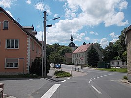
Town center
|
||
Burkartshain is a district of the northern Saxon town of Wurzen in the Leipzig district . Burkartshain and its neighboring town of Kühren , which merged in 1994 to form the municipality of Kühren-Burkartshain , are the largest districts of Wurzen after the city center.
geography
The place is seven and a half kilometers southeast of the city center south of federal highway 6 on state highway 47.
Surrounding towns are Nemt and Mühlbach in the northwest, Birkenhof in the north, Kühren in the northeast, Streuben in the east, Wäldgen in the southeast, Pyrna in the south, Nitzschka in the southwest and Oelschütz in the west.
history
Local history
The village "Borchardeshayn" (together with Sachsendorf) was first mentioned in 1284 in a border document. It was a Slavic round village that was expanded by German settlers.
The Burkartshain church was one of the first Protestant parish churches in Saxony as early as 1529. Its peasant baroque decoration, which has been preserved in style today, is remarkable .
In the middle of the 16th century there was evidence of a manor , which, however, only exercised the manorial rule over part of Burkartshain , another part was at the Mühlbach manor. For centuries the administration was also carried out proportionally by the offices of Wurzen and Grimma . When the administrative authorities in Saxony were formed, the village was united in the administrative authority of Grimma .
As a result of the administrative reform in the GDR in July 1952, it belonged to the Wurzen district in the Leipzig district , a forerunner of the Muldental district formed in 1994 , which was added to the Leipzig district in 2008.
On January 1, 1952, Mühlbach (with its district Kornhain ) was incorporated. Pyrna followed in 1956 and the two communities Nitzschka (with Oelschütz ) and Sachsendorf (with Wäldgen ) in 1974 , so that the now 3.1 km² community consisted of eight districts.
On January 1, 1994 the communities Burkartshain and Kühren merged to form Kühren-Burkartshain . With effect from October 1, 2006, this community was incorporated into the city of Wurzen .
Population development
| year | Residents |
|---|---|
| 1834 | 478 |
| 1871 | 673 |
| 1890 | 641 |
| 1910 | 669 |
| 1925 | 618 |
| 1939 | 650 |
| 1946 | 911 |
| 1950 | 1262 |
| 1964 | 1148 |
| 1991 | 1900 |
| 2010 | 699 |
In the middle of the 16th century, there were 47 farms and 35 residents in Burkartshain. In 1764, after the Seven Years' War , there were 47 farmers as well as a gardener and four cottage families .
The population was 478 in 1834 and rose to 673 by 1871, after which the number fluctuated between 600 and 700 inhabitants until the Second World War. After the war, the number of inhabitants rose to 1262 in 1950, but then fell by 10% by 1964 despite the incorporation of Mühlbach, Kornhain and Pyrna.
The community with its eight districts had 1900 inhabitants in 1991 with a slight downward trend.
Personalities
- Siegmund Brauner (* 1934), German philologist and Africanist
Sources and further reading
literature
- Christiane Rossner: The "jewelry box" found again. The von Holleuffers and their foundation for Burkartshain . In: German Foundation for Monument Protection (Hrsg.): Monuments. Magazine for monument culture in Germany . Number 1/2, 2008, ISSN 0941-7125 , p. 44-46 .
Footnotes
- ↑ a b Stadt Wurzen: Burkartshain ( Memento from February 23, 2014 in the Internet Archive )
- ↑ a b c Burkartshain in the Digital Historical Directory of Saxony
- ↑ a b Information for 14 0 55 050 Burkartshain municipality. In: Regional Register Saxony. State Statistical Office of the Free State of Saxony , accessed on March 25, 2014 .
- ↑ Federal Statistical Office (Ed.): Municipalities 1994 and their changes since 01.01.1948 in the new federal states . Metzler-Poeschel, Stuttgart 1995, ISBN 3-8246-0321-7 .
- ↑ StBA: Changes in the municipalities in Germany, see 2006
Web links
- Burkartshain district on the website of the city of Wurzen


