Bystryzja (river)
|
Bystrytsia River Бистриця, Быстрица, Bystrzyca |
||
|
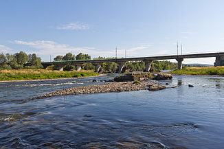
Bystryzja near Jesupil, shortly before the confluence with the Dniester |
||
| Data | ||
| location | Ivano-Frankivsk Oblast ( Ukraine ) | |
| River system | Dniester | |
| Drain over | Dniester → Black Sea | |
| confluence | from Bystryzja Nadwirnjanska and Bystryzja Solotwynska north of Ivano-Frankivsk 48 ° 57 ′ 39 ″ N , 24 ° 44 ′ 25 ″ E |
|
| muzzle | at Jesupil in the Dniester coordinates: 49 ° 2 '32 " N , 24 ° 48' 43" E 49 ° 2 '32 " N , 24 ° 48' 43" E
|
|
| length | 17 km | |
| Catchment area | approx. 2375 km² | |
| Small towns | Jesupil | |
| Bystryzja Nadvirnjanska | ||
|
The Bystryzja Nadwirnjanska at the northern exit of Nadwirna |
||
| Data | ||
| River system | Dniester | |
| source |
Gorgany Mountains ( Carpathians ) 48 ° 25 ′ 16 ″ N , 24 ° 14 ′ 39 ″ E |
|
| Union | with Bystryzja Solotwynska to Bystryzja 48 ° 57 ′ 39 ″ N , 24 ° 44 ′ 25 ″ E
|
|
| length | 94 km | |
| Catchment area | 1580 km² | |
| Big cities | Ivano-Frankivsk | |
| Medium-sized cities | Nadwirna | |
| Bystrytsia Solotvynska | ||
|
The Bystryzja Solotwynska near Drahomyrtschany, a few kilometers southwest of Ivano-Frankivsk |
||
| Data | ||
| River system | Dniester | |
| source |
Gorgany Mountains ( Carpathian Mountains ) 48 ° 32 ′ 3 ″ N , 24 ° 7 ′ 34 ″ E |
|
| Union | with Bystryzja Nadwirnjanska to Bystryzja 48 ° 57 ′ 39 ″ N , 24 ° 44 ′ 25 ″ E
|
|
| length | 82 km | |
| Catchment area | 795 km² | |
| Big cities | Ivano-Frankivsk | |
| Small towns | Solotvyn , Bohorodchany | |
| Communities | Lyssez | |
The Bystryzja ( Ukrainian Бистриця ; Russian Быстрица , Bystriza ; Polish Bystrzyca ) is a right tributary of the Dniester in western Ukraine .
The upper reaches of the Bystryzja is divided into two parts and named after the largest city adjacent to it: Bystryzja Nadwirnjanska (right, Ukrainian Бистриця Надвірнянська) after the city of Nadwirna or Bystryzja Solotvynska (left, Ukrainian Бистриця) after Solotvynska . The Bystryzja Nadwirnjanska (formerly also called Czarna Bystrzyca 'Black Bystryca' in Polish ) is 94 km long and has a catchment area of 1,580 km². The Bystryzja Solotwynska (formerly also called Złota Bystrzyca , Golden Bystryca 'in Polish ) is 82 km long and has a drainage area of 795 km². Both have their source in the Gorgany Mountains of the Ukrainian Carpathian Mountains ( Ivano-Frankivsk Oblast ), flow almost parallel to each other to the northeast and are typical mountain rivers until they reach the Sub-Carpathian Plain.
The two rivers flow together just north of Ivano-Frankivsk . The now unified Bystryzja flows into the Dniester after 17 km south of Halych near the town of Jesupil (Jezupol).
The name means something like “ quickly moving” from the Ukrainian word бистрий for “quickly” or “hurried”. Since the Bystryzja used to move its bed in the lower reaches of the plain, this was restricted by river dikes.
See also : Bystritza


