Cadereyta de Montes
| Cadereyta de Montes | ||
|---|---|---|
|
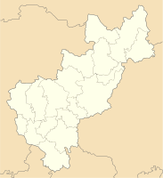
Coordinates: 20 ° 41 ′ N , 99 ° 49 ′ W Cadereyta de Montes on the map of Queretaro
|
||
| Basic data | ||
| Country | Mexico | |
| State | Querétaro | |
| Municipio | Cadereyta de Montes | |
| City foundation | 1640 | |
| Residents | 13,347 (2010) | |
| Detailed data | ||
| surface | 6.96 km 2 | |
| Population density | 1.918 inhabitants / km 2 | |
| height | 2040 m | |
|
Cadereyta de Montes - town center with the two main churches San Pedro y San Pablo (l.) And Templo de la Soledad (r.) |
||
Cadereyta de Montes is a small town with around 15,000 inhabitants and the capital of a municipality of the same name (municipio) with a total of around 70,000 inhabitants in the Mexican state of Querétaro . In 2011 the historical center of the city was classified as Pueblo Mágico .
Location and climate
The city of Cadereyta de Montes is located south of the Sierra Gorda approx. 215 km (driving distance) northwest of Mexico City at an average altitude of approx. 2040 m ; the city of Querétaro is about 72 km to the west. The climate is temperate to warm; Rain (approx. 505 mm / year) falls predominantly in the summer half-year.
Population development
| year | 2000 | 2005 | 2010 |
| Residents | 10,317 | 12.199 | 13,347 |
The slight but steady increase in population in the last few decades is mainly due to the continuing immigration of families from the surrounding villages. Most of the residents are of American Indian descent or mestizo .
economy
Today, animal husbandry (cattle, sheep, goats, pigs) plays the most important role in the life of the community; In addition, the cultivation of grain (maize, wheat, barley) and the cultivation of fruit and vegetables (beans, chillies, tomatoes, prickly pears, peaches, pears, figs, etc.) are important. Small traders, craftsmen and service providers of all kinds as well as health and training institutions have settled in the city itself.
history
Before the arrival of the Spaniards, the area around Cadereyta de Montes was in the hands of the nomadic Chichimec Indians, who were classified as warlike . In 1640, on the orders of Viceroy Lope Díaz de Armendáriz, a settlement called Villa de Cadereyta was founded, which was initially administered by the Franciscan Order . In 1861 the place received full city rights and only in 1902 its current name.
Attractions
- The Franciscan Church of San Pedro y San Pablo was built from rubble stones between 1725 and 1731 and then largely plastered ; in 1756 the red stone bell tower was supplemented with a lantern top. The nave has a transept and a crossing dome ; the apse houses an imposing baroque altar .
- The two- tower Templo de la Soledad immediately next to it was started in 1828 and completed a few years later; the church building belonged to the Servite Order , which was also active in Central America .
- The Palacio Municipal is a single-storey building from the 18th or 19th century.
- A city palace from the 18th century with a two-storey courtyard houses a cultural center (Centro Cultural) .
- Surroundings
- The former estate of Quinta Fernando Schmoll , located approx. 1.5 km east of the town center, houses an important botanical garden with numerous native and exotic plants, which are presented both outdoors and in greenhouses.
See also
Web links
- Cadereyta de Montes, history etc. - photos + information (Spanish)
- Cadereyta de Montes, tourism site - photos + brief information (Spanish)
- Cadereyta de Montes - Video (Spanish)

