
Sierra Gorda (Mexico)


The Sierra Gorda is a limestone mountain range up to 3,100 m high in the north of the Mexican state of Querétaro . Much of the mountain is designated as a biosphere reserve. The Franciscan Missions in Sierra Gorda were recognized as a World Heritage Site by UNESCO in 2003 .
geography
The Sierra Gorda, characterized by gorges ( canyons ), burglar dolines ( sótanos ) and karst caves ( cuevas ), covers the entire north of the state of Querétaro (municipalities: Peñamiller , Pinal de Amoles , Arroyo Seco , Jalpan de Serra and Landa de Matamoros ) as well as peripheral areas of the states Hidalgo , San Luis Potosí and Guanajuato . The mountains are on average approx. 1000 m high, but the heights range from approx. 700 to a maximum of approx. 3100 m. In the sparsely populated limestone mountains there are - in spite of the average annual rainfall of approx. 1000 mm - only a few rivers or streams, which, however, regularly dry out in the winter and spring months with little rain; the largest of these are the Río Jalpan , which has no drainage but is dammed up south of Jalpan de Serra, and the Río Extoraz near Peñamiller. The climate is temperate; Rain falls almost only in the summer months from June to September.
Population and economy
The predominantly Indian population of the Sierra Gorda ( Huasteken , Chichimeken and Otomí ) comprises around 100,000 people on an area of around 3500 km². Some of these lived until the 15th and 16th centuries. Still nomadic into the 20th century; The creation of fields was only possible in a few areas (mostly in the valley), as the rainwater quickly seeps away through the karst soil. Mainly maize , beans and opuntia were grown for the purpose of self-sufficiency ; turkeys were kept next to them and hunted. The Spaniards brought new crops to the region and changed the cultivation methods, but the principle of self-sufficiency remained largely intact until the middle of the 20th century. The Mexicans have recently discovered the Sierra Gorda as a holiday, hiking and climbing region.
history
Tancama is the only ruins from pre-Hispanic times in the Sierra Gorda area; she was probably already in the 2nd / 3rd Settled in the century AD; the buildings that are still visible, however, date from the 7th to 9th centuries. The sites of Las Ranas and Toluquilla are located on the southern edge of the mountains near San Joaquín . The Aztecs , which are present almost everywhere in central Mexico, as well as the Spanish conquistadors, showed little interest in the wooded but otherwise rather rugged and barren area. The missionary work of the Indians living here was initially in the hands of the Augustinian order , but eight years after an inspection trip by the Franciscan Lucas de los Ángeles it was placed in the hands of the Minorite Order by a decree of the Viceroy Luis de Velasco y Castilla in 1609. Its most important personality in the then viceroyalty of New Spain was St. Fra Junípero Serra , who founded several missionary monasteries in the 50s and 60s of the 18th century.
Attractions
Despite its remote location, the Sierra Gorda has several important sights:
- The mountain landscape is sometimes semi-desert, other regions are covered by dense bush forest.
- The Einbruchdoline of Sótano del Barro is considered the second largest in the world.
- The Swallow Cave has a diameter of only 50 m at the opening; inside the approx. 330 m deep cave this widens to approx. 150 m.
- In the Cañon del Paraiso in the municipality of Peñamiller and in the municipality of San Joaquín, there are Indian rock paintings of unknown age.
- The archaeological sites of Tancama , Las Ranas and Toluquilla are the only pre-Hispanic stone structures in the Sierra Gorda.
- The five Franciscan missions are part of the UNESCO World Heritage and show an extraordinary late baroque architecture.
- The small town of Jalpan de Serra belongs to the Pueblos Mágicos because of its historical center .
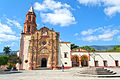
Misión de Santiago in Jalpan de Serra

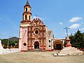
Misión de San Miguel Concá in Arroyo Seco
Misión de Nuestra Señora de la Luz in Tancoyol , Municipio Jalpan de Serra

Misión de Santa María de la Purísima Concepción in Landa de Matamoros


literature
- SC Lazcano: Las cavernas de la Sierra Gorda. Universidad Autónoma de Querétaro, 1986.
Web links
- Sierra Gorda - Official Website (Spanish)
- Sierra Gorda, sights - photos + short information (spanish)
- Sierra Gorda Photos
- Tancama - Info (INAH, Spanish)
- Las Ranas - Info (INAH, Spanish)
- Toluquilla - Infos (INAH, Spanish)