Landa de Matamoros
| Landa de Matamoros | ||
|---|---|---|
|
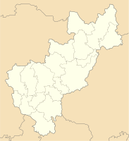
Coordinates: 21 ° 11 ′ N , 99 ° 19 ′ W Landa de Matamoros on the map of Queretaro
|
||
| Basic data | ||
| Country | Mexico | |
| State | Querétaro | |
| Municipio | Landa de Matamoros | |
| Residents | 1609 (2010) | |
| City insignia | ||
| Detailed data | ||
| height | 1040 m | |
| Post Code | 76360 | |
| Time zone | UTC −6 | |
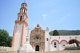
| Landa de Matamoros - Misión de Santa Maria del Agua de Landa | ||
| Misión de San Francisco de Asís del Valle de Tilaco | ||
Landa de Matamoros is a place with about 1,600 inhabitants in the north of the Mexican state of Querétaro . Landa de Matamoros is the administrative seat of the municipality of the same name, Landa de Matamoros, with around 20,000 inhabitants.
Like the entire municipality, Landa de Matamoros lies within the Sierra Gorda Biosphere Reserve . The Franciscan missions in the Sierra Gorda , including the Misión de Santa María de la Purísima Concepción del Agua de Landa near Landa de Matamoros , were recognized as a World Heritage Site by UNESCO in 2003 because of their historical and cultural significance .
location
Landa de Matamoros is located in a valley of the Sierra Gorda in the central highlands of Mexico at an altitude of approx. 1000 to 1100 m above sea level. d. M. Santiago de Querétaro , the capital of the state, is about 213 km to the southwest; the city of Jalpan de Serra is only about 20 km to the west. The climate is temperate and by Mexican standards quite rainy.
Population and economy
Only a small part of the community's inhabitants, who are mostly Chichimec, speak the regional language; and Nahuatl , the language of the Aztec conquerors has become rare; Colloquial language is mostly Spanish. In the villages of the community, corn, wheat, beans and vegetables are grown for self-sufficiency ; there are also numerous fruit trees. Several small craft businesses and shops have sprung up in the larger towns, and tourism also plays a certain role in the economic life of the municipality.
history
As early as the 2nd or 3rd century AD, the area was populated by the Huasteks who built the Tancama ceremonial square . In pre- Hispanic times the Sierra Gorda was inhabited by Nahuatl- speaking Pame and Junace Indians; some of them still lived nomadically and left no stone buildings. In the 15th century, the Aztecs conquered the region, but did not rule it completely. After the Spanish conquest of the Aztec Empire, Augustinian hermits came to the remote area in the middle of the 16th century ; however, they only stayed short. The first Franciscans came in the 16th century . In the 17th century members of a Tarasken tribe from Michoacán settled here; they are considered to be the actual founders of the place. Because of the remote location, the Spaniards did not care more about proselytizing the local population until the 17th and 18th centuries. It was above all the Franciscan Junípero Serra who in the 50s and 60s of the 18th century pushed forward the missionary work with great zeal and gave essential suggestions for the construction of the new church. In 1919 the old place name Agua (s) de Landa was changed to Landa de Matamoros - a memory of the priest and independence fighter Mariano Matamoros , who lived and worked in the area in 1807/08.
Attractions
- The current parish church of Santa María del Agua de Landa was since its construction in the years 1761 to 1764 (according to other sources 1760 to 1768 or even not until 1774) the monastery church of an important Franciscan mission. The tower, reinforced at the corners, has two bell-storeys with pilasters (below) and twisted columns (above) in the late Baroque style of Churriguerism . The actual facade of the church is structured by horizontal but broken cornices or by four rows of pilasters on the sides; between the rows of pilasters there are niches with figures of saints. To the left of the octagonal central window is another representation of the motif of two raised arms crossed, already known from Jalpan de Serra. The gable field is crowned by vase-like decorative motifs. To the right of the church facade is a capilla abierta . The nave is largely unadorned; Above the yoke in front of the flat-closing apse is a dome on an octagonal and illuminating drum .
- The façade of the Church of the Misión de San Francisco de Asís del Valle de Tilaco, which was also built in the second half of the 18th century, about 21 km to the east, is another architectural gem of the region. Here, too, the corners of the tower are reinforced; the lower bell floor has a square floor plan, the two upper floors are octagonal. The 3-storey middle section of the facade is structured by double rows of pilasters on each side in the Churrigueresque style ; There are figures of saints in the niches in between. Above the radially arched portal is the usual motif of two raised arms with hands nailed to the cross. The nave is unadorned. To the side of the church is a single-arched capilla abierta , in the middle of the huge square in front of the church there is a wrought-iron cross on a stepped octagonal base with a stone handle stand.
Web links
- Municipio de Landa - Photos + Info (Spanish)
- Landa de Matamoros and surroundings, sights - photos + brief information (Spanish)
- Misión Bucareli - Photo + Info (Spanish)
Individual evidence
- ^ Catálogo de Localidades
- ↑ Entry on the website of the UNESCO World Heritage Center ( English and French ).
- ↑ Landa de Matamoros - map with altitude information
- ↑ Landa de Matamoros - climate tables


