California State Route 73

|
||||||||||||||||||||||||||||||||||||||||||||||||||||||||||
|---|---|---|---|---|---|---|---|---|---|---|---|---|---|---|---|---|---|---|---|---|---|---|---|---|---|---|---|---|---|---|---|---|---|---|---|---|---|---|---|---|---|---|---|---|---|---|---|---|---|---|---|---|---|---|---|---|---|---|
| map | ||||||||||||||||||||||||||||||||||||||||||||||||||||||||||

|
||||||||||||||||||||||||||||||||||||||||||||||||||||||||||
| Basic data | ||||||||||||||||||||||||||||||||||||||||||||||||||||||||||
| Overall length: | 17.7 mi / 28.5 km | |||||||||||||||||||||||||||||||||||||||||||||||||||||||||
| Opening: | 1963 | |||||||||||||||||||||||||||||||||||||||||||||||||||||||||
| Starting point: |
|
|||||||||||||||||||||||||||||||||||||||||||||||||||||||||
| End point: |
|
|||||||||||||||||||||||||||||||||||||||||||||||||||||||||
| County: | Orange County | |||||||||||||||||||||||||||||||||||||||||||||||||||||||||
| Important cities: |
Mission Viejo Laguna Niguel Aliso Viejo Laguna Beach Irvine Newport Beach Costa Mesa |
|||||||||||||||||||||||||||||||||||||||||||||||||||||||||
|
course
|
||||||||||||||||||||||||||||||||||||||||||||||||||||||||||
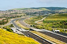
The California State Route 73 (abbreviated CA 73 or SR 73 ) is running in a north-south direction State Route in the US state of California . The 17.7 mile (28.5 km) road runs from Interstate 5 to Interstate 405 through the San Joaquin Hills . The northern section is known as the Corona del Mar Freeway . The southern part is called the San Joaquin Hills Transportation Corridor and is a toll road . State Route 73 runs roughly parallel to the Pacific Coast Highway .
The road is part of the California Freeway and Expressway System .
course
California State Route 73 begins near Mission Viejo on Interstate 5 , known as the San Diego Freeway . Use of the southern section is chargeable and has several toll stations. For the next 12 miles, the street is nicknamed the San Joaquin Hills Transportation Corridor . In a northerly direction it crosses the localities of Aliso Viejo and Laguna Niguel . In the urban area of Laguna Beach , the road in Laguna Canyon finally meets California State Route 133 .
In the further course the CA 73 winds through the mountains of the San Joaquin Hills , whereby it extends partially over the area of the Crystal Cove State Park . The following exits provide motorists with easy access to the UC Irvine site .
From Newport Beach , California State Route 73 is also known as the Corona del Mar Freeway . Residents can use the connection to reach the Newport Coast and Corona del Mar districts . The area of the John Wayne Airport (SNA) also affects the CA 73, which is flown over by aircraft taking off. Shortly after the junction with California State Route 55 , it finally ends on Interstate 405 in Costa Mesa .
history
California State Route 73 was built in the early 1960s. The road was intended to relieve the largely parallel Interstate 5 , Interstate 405 and California State Route 1 (Pacific Coast Highway). The original route of CA 73 followed the course of MacArthur Boulevard in Corona del Mar , where it flowed into the Pacific Coast Highway.
The San Joaquin Hills Transportation Corridor Agency (TCA) decided to continue the route as a toll road . As the road was supposed to run through the Laguna Canyon , there were violent protests. The southern section of CA 73 was completed in 1996.
See also
Web links
- Information on California highways (English)
- California @ AA Roads route description with photos
Individual evidence
- ↑ Streets and Highways Code Section 250-257. (No longer available online.) Official California Legislative Information , archived from the original on October 14, 2012 ; accessed on May 21, 2009 . Info: The archive link was inserted automatically and has not yet been checked. Please check the original and archive link according to the instructions and then remove this notice.
- ^ State Route 73. California Highways , accessed May 21, 2009 .
- ^ Lacy Atkins: Tollway Opponents Rally Environment. Los Angeles Times , accessed June 11, 2009 .
