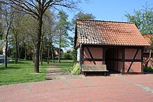
Calle (stooping)
|
Calle
Spots stooping
Coordinates: 52 ° 46 ′ 30 ″ N , 9 ° 4 ′ 31 ″ E
|
||
|---|---|---|
| Height : | 32 m | |
| Area : | 4.7 km² | |
| Residents : | 200 | |
| Population density : | 43 inhabitants / km² | |
| Incorporation : | March 1, 1974 | |
| Postal code : | 27333 | |
| Area code : | 04251 | |
|
Location of Calle in Lower Saxony |
||
Calle is a district of the borough stooping in Nienburg / Weser in Lower Saxony ( Germany ).
geography
Calle is located 25 km northwest of the district town of Nienburg / Weser between Bremen (46 km) and Hanover (74 km). Most of the village lies on a sand ridge on the edge of the old Weser glacial valley.
The village of Calle is 4.7 km² and has about 200 inhabitants.
history
1190 Calle is in a document Pope Clement III. mentioned. The prehistoric barrows from the Bronze Age , which can be found in the local area , show that Calle is much older . From 1677 to 1964 there was a school on Calle. Since March 1, 1974, Calle has been part of the municipality of Bücken.
Attractions
During the Advent season, a house on the road from Bücken to Asendorf is set up as a Christmas house. With its 450,000 lights, it is considered the largest Christmas house in Germany.
literature
- Patches stooping: 1100 years stooping. 882-1982. Festival Committee, Bücken 1982.
Web links
Individual evidence
- ^ Federal Statistical Office (ed.): Historical municipality directory for the Federal Republic of Germany. Name, border and key number changes in municipalities, counties and administrative districts from May 27, 1970 to December 31, 1982 . W. Kohlhammer GmbH, Stuttgart and Mainz 1983, ISBN 3-17-003263-1 , p. 191 .
- ↑ Thomas Bloch: Christmas House Calle, largest Christmas house in Germany and Europe with 420,000 lights


