Cardona (Rizal)
| Municipality of Cardona | ||
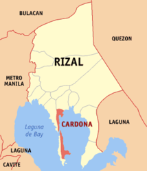
| Location of Cardona in the province of Rizal | ||
|---|---|---|

|
||
| Basic data | ||
| Region : | CALABARZON | |
| Province : | Rizal | |
| Barangays : | 18th | |
| District: | 2. District of Rizal | |
| PSGC : | 045806000 | |
| Income class : | 3rd income bracket | |
| Households : |
May 1, 2000 census
|
|
| Population : | 49.034 August 1, 2015 census
|
|
| Population density : | 1717 inhabitants per km² | |
| Area : | 28.56 km² | |
| Coordinates : | 14 ° 29 ′ N , 121 ° 14 ′ E | |
| Postal code : | 1950 | |
| Geographical location in the Philippines | ||
|
|
||
Cardona is a Filipino municipality in the province of Rizal , in the administrative region IV, Calabarzon. It has 49,034 inhabitants (August 1, 2015 census) who lived in 18 barangays . It is classified as a second income class community in the Philippines and as partially urbanized .
Cardona lies on the shores of the largest inland lake in the Philippines, the Laguna de Bay . Their neighboring communities are Binangonan in the west and Morong in the north. The topography of the municipality is characterized by the southern foothills of the central Luzon plain.
Barangays
|
|
