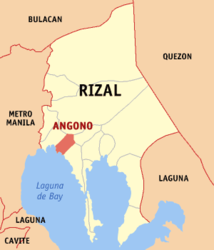
Angono
| Municipality of Angono | ||
| Location of Angono in the province of Rizal | ||
|---|---|---|

|
||
| Basic data | ||
| Region : | CALABARZON | |
| Province : | Rizal | |
| Barangays : | 10 | |
| District: | 1. District of Rizal | |
| PSGC : | 045801000 | |
| Income class : | 1st income bracket | |
| Households : |
May 1, 2000 census
|
|
| Population : | 113.283 August 1, 2015 census
|
|
| Population density : | 4320 inhabitants per km² | |
| Area : | 26.22 km² | |
| Coordinates : | 14 ° 31 ' N , 121 ° 9' E | |
| Postal code : | 1930 | |
| Geographical location in the Philippines | ||
|
|
||
Angono is a Filipino municipality in the province of Rizal , in the administrative region IV, Calabarzon. It has 113,283 inhabitants (August 1, 2015 census) who lived in 10 barangays . It is classified as the first income class community in the Philippines and as urbanized .
Angono is located on the northern shore of the largest inland lake in the Philippines, the Laguna de Bay . The topography of the municipality is characterized by the southeastern foothills of the Central Luzon Plain and to the north by the western foothills of the Sierra Madre . Their neighboring communities are Taytay in the west, Antipolo City in the north, Binangonan in the southeast and Teresa in the northeast.
The earliest artistic representations in the field of the Philippines are found on the border with Antipolo City and Binangonan . They are known as the Angono petroglyphs .
Barangays
- Bagumbayan
- Kalayaan
- Mahabang Parang
- Poblacion Ibaba
- Poblacion Itaas
- San Isidro
- Santo Niño
- San Pedro
- San Roque
- San Vicente

