
Castell de sa Punta de n'Amer
| Castell de sa Punta de n'Amer | ||
|---|---|---|
 West side of the Castell de sa Punta de n'Amer |
||
| Alternative name (s): | Castell de n'Amer | |
| Creation time : | 1693 to 1696 | |
| Conservation status: | Preserved essential parts | |
| Construction: | Marès - masonry | |
| Place: | Punta de n'Amer , Sant Llorenç des Cardassar | |
| Geographical location | 39 ° 34 '48 " N , 3 ° 23' 46" E | |
| Height: | 35 msnm | |
|
||

Es Castell de sa Punta de n'Amer ("The castle of Punta de n'Amer ", also just Es Castell or Castell de n'Amer ) is a defense tower from the 17th century on the east coast of the Spanish Balearic island of Mallorca . It is located on the Punta de n'Amer peninsula in the municipality of Sant Llorenç des Cardassar , about ten kilometers southeast of the town of Sant Llorenç des Cardassar.
Location and description

The Punta de n'Amer peninsula is a nature reserve between the tourist areas of Cala Millor and Sa Coma . Both places belong to the municipality of Sant Llorenç des Cardassar. The Castell de sa Punta de n'Amer is located in the eastern part of the peninsula, about the same distance to the north and south coast of Punta de n'Amer . The local limit of Cala Millor is about 1100 meters northwest of the Castell , that of Sa Coma 1500 meters in the southwest. The distance to the most easterly point of the peninsula is not quite 700 meters.
Es Castell is located at an altitude of 35 meters above sea level. It consists of ashlar stones of the typical Mallorcan Marès rock, which was quarried on Punta de n'Amer , and is a mixture of a cubic gun turret and a rectangular pyramid. Located in the dunes, it was fully geared towards gun combat. The mechanism of the drawbridge and the four loopholes on the respective sides can be reached via a surrounding wooden parapet. In the trench surrounding the fortification there is a kind of cistern and a storage bunker.
The upper platform of the tower can be reached via a stone spiral staircase. A cannon of the Scorpion type placed on the gun platform shows that the coast in front of the defense tower could be painted accordingly. In 1969 the tower including the wooden drawbridge was restored and given its present condition. The interior houses some showcases in which exhibits and documents on the history of the building are shown. The Castell is freely accessible to everyone during the day.
history

As early as 1585, against the background of the constant attacks and raids by pirates and North African corsairs on Mallorca's coasts (15th to 18th centuries), the viceroy Lluis Vich, as part of a general inspection, indicated the need to build a defense tower on Punta de n ' Amer established. After another major attack in 1611, the council of the city of Manacor, to whose area the peninsula belonged at that time, decided to build the tower in 1617, which, however, could not be realized for cost reasons. The construction of the Castell began in 1693 , after the captain of Muro ( Capità de Muro ) was captured in one of these raids on the island on September 4, 1688, in addition to some fishermen , and the General Council of Mallorca then supported the Baus agreed.

The tower, completed in 1696, served not only as a direct defense for the residents of the east coast, but also as an observation and reporting tower. It was part of the coastal fortress network of Mallorca, consisting of a large number of towers, on which the corps of tower guards was deployed. Three tower guards with arquebuses , muskets and long- barreled pistols ( Espingardes ), all handguns and grappling hooks, were stationed at Es Castell . In addition, the upper platform was equipped with two bronze cannons of different calibers . To ward off direct attacks, the fortification was surrounded by a ditch carved into the rock, which could be crossed by a drawbridge . In the event of a defense, the raised bridge protected the entrance door of the tower.
As the threat of attack decreased in the middle of the 19th century, the tower was auctioned off and became private property. During the Spanish Civil War from 1936 to 1939, the Punta de n'Amer peninsula was an important base for the army. The Castell served as a news location for the national eavesdropping network and as a repository for the nationalists . The Punta de n'Amer peninsula , including parts of the east coast, was briefly occupied by republican troops from mid-August to early September 1936 during the “ Battle of Mallorca ” . After their departure, the defense tower served the Franquists to monitor the eastern coastal waters. They built an outbuilding at the foot of the castle to house soldiers. Today there is a restaurant in it.
- Views of the castle
 Last cannon on the northeastern sea side
 Stone spiral staircase (north side)
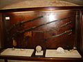 Small arms show in the interior
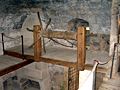 Drawbridge mechanism and chimney


Access
Some hiking trails lead through the nature reserve of Punta de n'Amer , on which the Castell can be reached from both Cala Millor and Sa Coma. The main access route, which also serves to supply the restaurant located next to the Castell , starts at Rancho de Sa Coma , near the beach of Sa Coma, and is about 1500 meters long. The ways to the Castell are signposted.
supporting documents
- Jaume Bassa Burgdorf: Sa Punta de n'Amer , Ajuntament de Sant Llorenç des Cardassar, Delegació de Turisme
- La Punta de n'Amer , Ajuntament de Sant Llorenç des Cardassar (information sheet) (PDF file; 883 kB)
- Es Castell de Punta de n'Amer , web page describing the castle (see also: web links)
- Rutes a peu - Son Servera i Sant Llorenç , Institut Balear del Turisme / Consell de Mallorca, Ajuntament de Sant Llorenç des Cardassar / Ajuntament de Son Servera
- Exhibits (books pages and cards) that are in display cases of Castell de sa Punta de n'Amer are
Individual evidence
- ↑ Alexander Sepasgosarian: The hour of the victors. Mallorca Magazin, October 6, 2011, accessed on October 11, 2011 .