Cala Millor


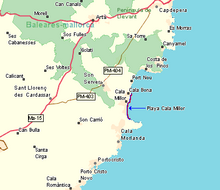
Cala Millor ("Best Bay") is a tourist destination on the Spanish Balearic island of Mallorca . It is located on the east coast of the island in the region ( Comarca ) Llevant on the Badia de Son Servera in the holiday area named after him ( Destino de Cala Millor ).
Cala Millor has 5778 inhabitants (as of 2016). The northern Cala Millor belongs to the municipality of Son Servera , the southern area, in the direction of the Punta de n'Amer peninsula , belongs to the municipality of Sant Llorenç des Cardassar . The border between the two municipalities is on Carrer de sa Figuera and Carrer de Sol Naixent streets .
location
Cala Millor is located 64 kilometers from Palma and 17 kilometers from Manacor on the Bay of Son Servera ( Badia de Son Servera ), a large section of the sea on the east coast of Mallorca between the Cap des Pinar in the north and the Punta de n'Amer peninsula in the south. Badia d'Artà is also used as the name of the bay from the time when the municipalities of Son Servera , Capdepera and Artà formed the larger municipality of Artà.
In the north, the development on the Carrer de la Magnòlia street merges with that of the neighboring town of Cala Bona ; there is the nearest port. To the south, Cala Millor has expanded in recent decades to the beginning of the Punta de n'Amer peninsula on Cala Nau and merged with the districts of Son Moro and Son Moro Bonavista of the municipality of Sant Llorenç des Cardassar.
The western border of the town of Cala Millor is the MA-4027 road from Cala Bona towards Porto Cristo . The closed development of the tourist resort has not yet reached the street. Two kilometers to the west, via the MA-4026 road, is the small town of Son Servera, built in a traditional Mallorcan style. From there, Sant Llorenç des Cardassar is a further seven kilometers in the interior of the island.
The holiday area of Cala Millor also includes the towns of Son Servera, Sant Llorenç des Cardassar and Son Carrie in the hinterland and the five neighboring coastal towns of Sa Coma , Cala Bona, Costa dels Pins and S'Illot . With over 35,000 hotel spaces, the destination is the third largest tourist destination in the Balearic Islands.
history
The first buildings were built around 1930. In 1934, Jaume Vicens Andreu built the first hotel facility, the Hotel Eureka, which laid the foundation for today's tourist center. The Hotel Sabina followed in 1958 and several hotels, shops and restaurants were opened.
In 1962, Joan Llinàs designed a promenade primarily on the beach of Cala Millor, which also bears his name. In 1965, this zone was further expanded by a general urban development plan and thus reached the neighboring town of Cala Bona in the 1970s .
Many German and British citizens have settled here or have their second homes. In 2004, Cala Millor and Cala Bona together had 46 hotels and 17 aparthotels as well as several apartment complexes and guest houses.
Culture and sights
Churches
Parròquia de Nostra Senyora dels Àngels
The modern low-rise parish church of the Mother of God of Angels , the patron saint of Cala Millor, is located on Carrer des Rafalet in the municipality of Son Servera.
Theaters and cultural centers
Auditòrium Sa Màniga
The Congress and Cultural Center (Auditorium) of Cala Millor, opened in 1999, is located in the municipality of Sant Llorenç des Cardassar on Carrer de Son Galta 4 . The large event hall offers space for 472 spectators. There are also other halls and an exhibition room.
Beach
The sandy beach of Cala Millor extends over a length of 1,800 meters and has an average width of 30 to 35 meters. It is very popular during the season. The former dunes behind the beach were built over with a promenade and hotels, shops and restaurants behind it. The beach is divided geographically, historically and administratively into four sections:
- Cala Millor (Arenal de Son Servera)
- Cala Millor (Platja de Sant Llorenç)
- Son Moro (Platja de Sant Llorenç)
- Cala Nau
The northernmost section of the beach is called Arenal de Son Servera because it belongs to Son Servera . It is about 400 meters long and is located directly on the Cala Millor bay . This is where the first hotels in the village were located and it is the starting point for the history of the settlement of Cala Millor. The beach was awarded the blue flag in 2019 , which is awarded annually for sustainable development and compliance with strict criteria at ports and beaches.
The Platja de Sant Llorenç connects to the south . It is 1,200 meters long and got its name as the beach of the municipality of Sant Llorenç des Cardassar. Its repeated subdivision into two sections of roughly the same length is due to the building history and location. The northern section of the Platja de Sant Llorenç is still partly on the Cala Millor bay . Behind him is the place Son Moro Bonavista, as a result of the first southern expansion of the tourist resort to the area of Sant Llorenç today practically a district of Cala Millor.
With the subsequent expansion of the settlement towards Punta de n'Amer , the village of Son Moro was also taken over by Cala Millor. Son Moro is located around the area of today's Parc de la Mar . The local section of Platja de Sant Llorenç , also known as Estanyol d'en Roig , cannot be assigned to any of the adjacent bays of Cala Millor or Cala Nau .
The Cala Nau forms the southern end of the beach of Cala Millor. The approximately 200 meter long beach merges with the rocky coast of the Punta de n'Amer peninsula at its end . The coastline swings from the south orientation of the beach to the east and thus forms the small bay.
When the storm "Gloria" hit the east coast on January 20 and 21, 2020 with heavy rain and gigantic waves, the tourist area of Cala Millor was badly affected. Much of the sand was washed away. Since the Spanish government pays too little aid money to procure sand, the citizens were called on to large demonstrations and to clean up; At the end of April 2020, however, the municipality declared that the beach had receded almost independently.
Markets
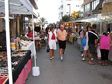
There has been a weekly market since 2007, currently on Carrer de Na Penyal . Market day has been Monday since 2013, on which goods are offered on the street, which is then closed to traffic, which are mostly aimed at the needs of tourists.
Festivals
- Nostra Senyora dels Àngels
The name day of the town's patron saint is celebrated on August 2nd every year in Cala Millor.
- Festival del Turista
The tourist festivals take place in the last week of September of each year. They were created with the intention of extending the summer tourist season. Various concerts, dances and sporting events are organized. The conclusion is a traditional beach fireworks display at the end of the festival week.
Other festivals
Once a year the car park (Carrer de Fetget, Son Servera) is made available by showmen for an amusement park.
traffic

Cala Millor and surrounding a wrong as "Minitren" (Eng .: mini train) called trackless train .
supporting documents
- ↑ Population statistics for Cala Millor by the Instituto Nacional de Estadística español (INE): Cala Millor (municipality of Son Servera) and Son Moro & Son Moro Bonavista (municipality of Sant Llorenç des Cardassar). Accessed August 23, 2017 (English / Spanish).
- ↑ Consorci de Turisme (tourism association) of the municipal administrations with the Asociación Hotelera de Cala Millor - Sa Coma (German)
- ↑ Cala Millor. Retrieved July 21, 2020 .
- ↑ Mallorca newspaper: Anger on the East Coast ... , February 20, 2020
- ↑ In each case Mallorca newspaper: Sand for the beaches of Mallorca , March 18, 2020. Biel Capó: Beach of Cala Millor ... regenerates itself , April 28, 2020
Web links
- Tourist information of the Tourism Consortium of Son Servera and Sant Llorenç des Cardassar
Coordinates: 39 ° 36 ' N , 3 ° 23' E


