Sa Coma
| Municipality of Sant Llorenç des Cardassar: Sa Coma | ||
|---|---|---|
| coat of arms | Map of Spain | |
 Help on coat of arms |
|
|
| Basic data | ||
| Autonomous Community : | Balearic Islands | |
| Island: | Mallorca | |
| Comarca : | Llevant | |
| Coordinates | 39 ° 35 ' N , 3 ° 22' E | |
| Residents : | 3,045 (2011) INE | |
| Area code: | 07051000500 | |
| Location of the place | ||

|
||
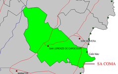
Sa Coma (translated "valley floor") is a place marked by tourism on the east coast of the Spanish Balearic island of Mallorca in the region ( Comarca ) Llevant .
In 2011 it had 3,045 inhabitants, 13 of whom lived outside the settlement core. At the beginning of 2018 there were 2548 inhabitants. The village is part of the municipality of Sant Llorenç des Cardassar .
Location and infrastructure
Sa Coma is located 63 km east of Palma and 16 km east of Manacor . You can reach the place coming from the west via the MA-4021 from Manacor, coming from the south via the coastal route from Santanyí , past Porto Cristo and S'Illot . The place belongs to the holiday area of Cala Millor . It is well connected to the surrounding area by numerous bus connections. A small mini train connects Sa Coma with the resorts of the holiday area. A small shipping pier is located at the southern end of the beach.
Beach
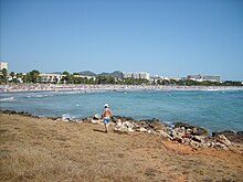
The sandy beach of Sa Coma extends over a length of 800 meters and has an average width of about 30 meters, sometimes up to 60 meters. It was awarded the Blue Flag for its good water quality . Directly behind him runs the promenade, which merges into the waterfront of the smaller tourist town of S'Illot in the south .
The beach is considered to be dangerous because of the under-currents that are often underestimated.
Attractions
- Talaiot Na Pol
- This circular talaiot (Spanish: talayot ), i.e. megalithic defense or watchtower, is located in the north of the village on the corner of Carrer Pomeres - Carrer Roses . It is the remains of a conical structure with a diameter of 12.5 meters. The walls are 3.5 meters high and 2 meters wide and were built from large stone blocks. Some of the outbuildings are in a honeycomb shape against the main talaiot and are surrounded by an arched wall. In the lower area there is a converted natural cave, the function of which could not be clarified.
- Safari park
- This is located on a 40 hectare site in the north of the village. You can drive through it with your own vehicle or one of the park's vehicles. Mostly African steppe animals and monkeys can be seen in the wild. An integrated small zoo also houses enclosures for predators, elephants, monkeys and other animals. There is a restaurant and two small show stages.
- Punta de n'Amer
- The approximately 200 hectare Punta de n'Amer peninsula is a nature reserve and connects directly to the north of the village at the end of the beach promenade. This landscape can be explored on numerous small paths. The Castell , built in 1696 , a fortified tower that was once used to protect against pirates, is open to the public with free admission. It houses a small museum and serves as a viewpoint over the bay of Son Servera .
- Remains of the from around 1100 BC. Settlements of the Talayot culture dating back to 8 BC can be found in the southern neighboring town of S'Illot .
- Coves del Drac
- The large walkable stalactite cave system Coves del Drac ( Dragon Caves ) is located about nine kilometers southeast of Sa Coma near Portocristo. It extends over 1700 meters and has six lakes. Europe's largest underground lake is located here, the Llac Martel . Concerts are held regularly inside the cave.
- "Paradis" mini golf
- In Sa Coma there is the “Paradis” mini golf course in addition to other sports and leisure facilities . It is fitted into a large park with palm trees, other exotic plants and artificial waterfalls and is located behind the “Safari Park” hotel.
Annual festivals and events
- The Fiestas Patronales de Santa Maria de Sa Coma take place every year around September 16.
- The Fiestas del Turista were created with the intention of extending the tourist summer season and take place annually around the last weekend in September in S'Illot as well as in Cala Millor and Sa Coma.
- The Mallorca Smooth Jazz Festival takes place every year in late April / early May in Sa Coma.
Web links
- German-language website of the Tourism Association of the Municipalities and Hoteliers of Cala Millor - Sa Coma
Individual evidence
- ↑ Population statistics for Sa Coma of the Instituto Nacional de Estadística español (INE). Accessed on December 16, 2012 (English / Spanish).
- ↑ Evaluation (Spanish) of the Institut d´Estadistica de les Illes de Balears (IBESTAT), under “Población” with history
- ↑ data sheet of the local tourism association
- ↑ Mallorca: Fatal swimming accidents trigger safety concerns. In: Spiegel Online . September 16, 2009, accessed June 9, 2018 . Driven on the beach by Heike Vowinkel in “Welt am Sonntag” on August 10, 2003, accessed on December 31, 2019
- ↑ Gabriel Pons i Homar: Archaeological Paths: S'Illot - Sa Coma . Guide and historical introduction. Ajuntament de Sant Llorenç des Cardassar, Sant Llorenç des Cardassar 1994, Na Pol, p. 14–15 ( digitized [PDF; 455 kB ; accessed on September 3, 2016]). Digitized version ( Memento of the original from August 12, 2012 in the Internet Archive ) Info: The archive link was inserted automatically and has not yet been checked. Please check the original and archive link according to the instructions and then remove this notice.


